Give us feedback!

Our philosophy is simple. We want to encourage you to dream. BIG! Then we help you plan your trip, get the most out of it while you're traveling and help you share your experience with friends.
Join Now It's FREE
Related Categories
Dreams Still To Do
Checked-Off Dreams
Dreams Still To Do
Checked-Off Dreams
Advertisement
Explore Bureau of Land Management (BLM)
-
Explore Adobe Town WSA, Wyoming
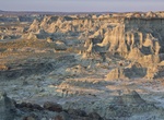
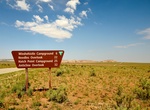
At 85,710 acres in size, Adobe Town WSA is the largest in Wyoming. Within the WSA, you'll find Skull Creek Rim and Monument Valley - names that conjure up images of colorful badlands, buttes and spires created by thousands of years of erosion. Located 80 miles southwest of Rawlins, outstanding opportunities for solitude and primitive and unconfined recreation exist i... -
Off-road Afton Canyon, California
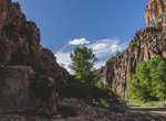
Within the Mojave Trails National National Monument -- the Mojave River flows through scenic Afton Canyon east of Barstow. Water still flows most of the year through this Canyon. Sheer walls in every imaginable shade of pink tower 300 feet above the Mojave River. Four major trails of varying lengths take visitors past these varicolored cliffs and through nooks and ... -
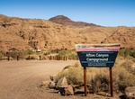
Camp at Afton Canyon Campground, California
Afton Canyon's surface water makes it unique in the southern California desert. Known locally as "The Grand Canyon of the Mojave" for its dramatic geological formations, this is the only place where the Mojave River flows above ground year-round - providing significant riparian (riverbank) wildlife habitat amid the desert. Since prehistoric times, the natural bounty c... -
Hike Afton Canyon “Spooky Cave”, California
An interesting narrow slot to visit when in Afton Canyon. The canyon is approached from the bottom by ascending the canyon itself. First you go up canyon climbing the drops with partner assists and occasionally some static ropes. Then you come back down with the option to rappel or just handline it. Make sure you pack a headlamp. The canyon gets so narrow and the wall... -
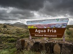
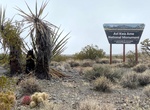
Visit Agua Fria National Monument, Arizona
Agua Fria National Monument is located in the U.S. state of Arizona, approximately 40 miles north of downtown Phoenix, Arizona. Created by Presidential proclamation on January 11, 2000, the 70,900-acre monument is managed by the Bureau of Land Management, an agency within the U.S. Department of the Interior. The Bureau of Land Management already managed the lands; how... -
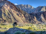
Camp at Aguirre Spring Campground, New Mexico
The high wall, needle-like spires of the Organ Mountains curve dramatically around a semicircle of Chihuahuan Desert habitat at the Aguirre Spring Campground. The campground, nestled at the base of spectacular cliffs, overlooks the Tularosa Basin and White Sands National Monument. Alligator juniper, gray oak, mountain mahogany and sotol are a few of the abundant plant... -
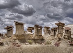
Explore Ah-Shi-Sle-Pah Wilderness, New Mexico
Ah-Shi-Sle-Pah Wilderness is located in San Juan County, New Mexico, between Chaco Canyon and the De-Na-Zin Wilderness. The wilderness has multicolored badlands, sandstone hoodoos, petrified wood and dinosaur bones, similar to those found in the nearby Bisti Badlands and De-Na-Zin Wilderness. BLM closed the jeep trail to this point, which overlooks the Ahshislepah Wil... -
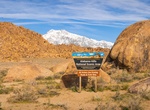
Explore Alabama Hills, California
Alabama Hills is known for its rock formations that have atracted movie makers, photographers and tourist from all over the world. The hills are located in Inyo County, California. Explore the hills by cara, bike or hiking. Since the early 1920's, move stars such as Gen Autry, Hopalong Cassidy and the Lone Ranger have been shooting it out with outlaws in the Alabama H... -
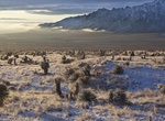
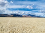
Explore Alvord Desert, Oregon
The Alvord Desert is a desert located in Harney County, in southeastern Oregon in the western United States. It is roughly southeast of Steens Mountain. The Alvord Desert is a 12-by-7-mile (19 by 11 km) dry lake bed and averages 7 inches (180 mm) of rain a year. Two mountain ranges separate it from the Pacific Ocean—the Coast Range, and the Cascade Mountains. Al... -
Drive to Anticline Overlook (Hatch Point Road), Moab, Utah
The Anticline Overlook is named for the curved, uplifted Kane Creek Anticline visible across the Colorado River to the north. About 5200 feet of salt-baring rocks, remnants from ancient seas, lie beneath the Kane Creek anticline in the Paradox Member of the Hermosa Formation. The Intrepid Potash mining facility and solar evaporation ponds are visible from the overlook... -
Explore Aravaipa Canyon Wilderness, Arizona
Aravaipa Canyon Wilderness is a 19,410 acres (7,850 ha) wilderness area located in the U.S. State of Arizona. The wilderness is administered by the BLM and is located northeast of Mammoth, Arizona in Graham and Pinal counties, about 120 miles (190 km) southeast of Phoenix. Pedestrian access to the preserve is allowed only with prior authorization from preserve staff. ... -
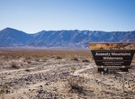
Explore Avawatz Moutains Wilderness, California
Rising to more than 6,100 feet above the Silurian Valley, the Avawatz Mountains form a commanding backdrop of colorful eroded slopes, rugged ridges, and steep, narrow canyons. The name "Avawatz" is derived from a Mohave Indian term meaning "red rock." And in fact, members of the Shoshone Nation continue to visit the area for spiritual and cultural purposes, collecting... -
Explore Avi Kwa Ame National Monument, Nevada
Avi Kwa Ame National Monument is a national monument that protects approximately 506,000 acres (2,050 km2) of the Mojave Desert in southern Nevada. President Joe Biden established it with the authority in the Antiquities Act on March 21, 2023. It is named for Avi Kwa Ame, also known as Spirit Mountain, which is visible from most of the monument and is considered sacre... -
Explore Basin and Range National Monument, Nevada
The Basin and Range National Monument in Nevada is located two hours from Las Vegas. It became a National Monument in July, 2015. The Basin and Range area of southeastern Nevada is an iconic American landscape. The area is one of the most undisturbed corners of the broader Great Basin region, which extends from the Sierra Nevada Mountains in the west to the Colorado ... -
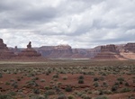
Explore Bears Ears National Monument, Utah
Bears Ears National Monument is a United States national monument located in San Juan County in southeastern Utah, established by President Barack Obama by presidential proclamation on December 28, 2016. The monument protects 1,351,849 acres (2,112.264 sq mi; 5,470.74 km2) of public land surrounding the Bears Ears—a pair of buttes—and the Indian Creek corr...