Give us feedback!


 See all

Our philosophy is simple. We want to encourage you to dream. BIG! Then we help you plan your trip, get the most out of it while you're traveling and help you share your experience with friends.
Join Now It's FREE
Dream Packages
Duration: 3 days
Price: $495.00
Price: $495.00
Duration: 6 to 7 hours
Price: $616.54
Price: $616.54
Duration: 10 hours
Price: $270.00
Price: $270.00
Duration: 4 hours
Price: $149.99
Price: $149.99
Related Categories
Dreams Still To Do
Checked-Off Dreams
Dreams Still To Do
Checked-Off Dreams
Advertisement
Explore Canyons
-
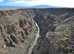
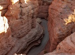
Explore Rio Grande Gorge, New Mexico
The Rio Grande Gorge runs from northwest to southeast of Taos, New Mexico, through the basalt flows of the Taos Plateau volcanic field. The gorge depth is 800 feet just south of the Gorge Bridge, which spans the gorge ten miles northwest of Taos. The gorge has white water rapids and many ancient petroglyphs. At the bottom of the gorge, the Rio Grande is flanked by hi... -
Explore River Lethe Gorge, Katmai National Park, Alaska
River Lethe is located 18 km (12 mi) west of Mount Katmai, Alaska Peninsula, and is the middle branch of the Ukak River. It flows through the Valley of Ten Thousand Smokes. The river was named in 1917 by R. F. Griggs, National Geographic Society; inspired by Lethe, the "river of forgetfulness" in the Hades of Greek mythology. A dry channel on Mars (which could carry... -
Hike Road Canyon, Cedar Mesa, Bears Ears National Monument, Utah
NOTE: A permit to hike or backpack is required. Road Canyon is accessed from the Cigarette Springs Road on Cedar Mesa. The elevation in the upper ends of Road Canyon begins at approximately 6,200 feet and drops to 4,900 feet at the lower ends. The walls of the canyon vary from 100 feet in the upper ends to over 500 feet in the lower ends. Erosion of the colorful Ceda... -
Explore Rock Canyon, Provo, Utah
Rock Canyon is located in the Wasatch Mountains, in east Provo, Utah, United States.[Note 1] It is popular with rock climbers and hikers (and a number of other outdoor enthusiasts of all types) due to its unique and rugged geology as well as its proximity to Brigham Young University. The mouth of the canyon is located just behind the Provo Utah Temple. Recorded histor... -
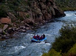
Raft or Kayak Royal Gorge, Colorado
The Royal Gorge (also Grand Canyon of the Arkansas) is a canyon on the Arkansas River near Cañon City, Colorado. With a width of 50 feet (15 m) at its base and a few hundred feet at its top, and a depth of 1,250 feet (380 m) in places, the 10-mile-long canyon is a narrow, steep gorge through the granite of Fremont Peak. It is one of the deepest canyons in Color... -
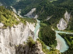
Explore Ruinaulta, Grisons, Switzerland
Ruinaulta is a canyon created by the Anterior Rhine byIlanz/Glion and Reichenau in the debris of the Flims Rockslide just upstream of its confluence with the Posterior Rhine at Reichenau in the Grisons, eastern Switzerland. It is sometimes known as theRhine Gorge, or sometimes rather ironically calledSwiss Grand Canyon. Protected by cliffs several hundred metres high,... -
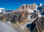
See Ruth Glacier (Grand Gorge), Denali National Park, Alaska
Ruth Glacier is a glacier in Denali National Park and Preserve in the U.S. state of Alaska. Its upper reaches are approximately 3 vertical miles below the summit of Denali. The glacier's "Great Gorge" is one mile wide, and drops almost 2,000 feet (610 m) over 10 miles (16 km), with crevasses along the surface. Above the surface on both sides are 4,900 feet (1,500 m) g... -
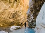
Hike Saklıkent Canyon, Turkey
Saklıkent Canyon is cut into slopes of the Akdağlar Mountains in Turkey's Muğla province, 50 km from Fethiye. The canyon is 300 meters deep and 18 km long, one of the deepest in the world, resulting from the abrasion of the rocks by flowing waters over thousands of years. At the mouth of the gorge, there is a wooden boardwalk above the river. Summer is the best time t... -
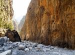
Explore Samariá Gorge, Crete, Greece
The Samariá Gorge is a National Park of Greece on the island of Crete - a major tourist attraction of the island - and a World's Biosphere Reserve. The gorge is in southwest Crete in the prefecture of Chania. It was created by a small river running between the White Mountains (Lefká Óri) and Mt. Volakias. There are a number of other gorges in the ... -
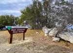
Explore San Joaquin River Gorge, California
The scenic San Joaquin River Gorge Special Recreation Management Area straddles the San Joaquin River just upstream from Millerton Lake State Recreation Area and includes lands in both Fresno and Madera Counties. Multiple campground and day-use sites are available for your enjoyment including: Ya-Gub-Weh-Tuh Campground, Aholul Group Campground, Equestrian Campground, ... -
Explore San Lorenzo Canyon, New Mexico
San Lorenzo Canyon is jointly managed by the U.S. Fish and Wildlife Service and the Bureau of Land Management as a primitive recreation area. This scenic east-west canyon offers ample outdoor opportunities for hiking and primitive camping. Not only a destination for hikers, the Canyon offers outstanding opportunities for photographers. Millions of years of Earth&rsquo... -
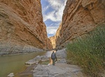
Hike Santa Elena Canyon Trail, Big Bend National Park, Texas
This trail leads into the stunning Santa Elena Canyon. After crossing Terlingua Creek, the trail ascends on paved steps to a vista, then descends back to the water's edge, continuing into the canyon until the canyon walls meet the water. A Big Bend classic. Trail is impassable when Terlingua Creek floods. Trail begins at terminus of the Ross Maxwell Scenic Drive. -
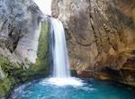
Hike Sapadere Canyon Waterfalls, Turkey
Sapadere Canyon is located in Turkey 48 km northeast from Alanya and 20 km away from Demirtas. The hike along the Sedre River will take you to the end of Sapadere Canyon. The canyon has walking platforms along much of the canyon, making this an easy hike. At the end of the 600m long platform you will find the main waterfall in the canton, where it is still possible t... -
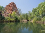
Visit Sawpit Gorge, Western Australia
The gorge is located on the Black Elvire River where flood waters have cut through a range. There is a towering rock wall on one side and sandy shaded banks. This is one of the more secluded and beautiful locations in the Shire of Halls Creek.It is also a great place for a bushwalk with plenty of wildlife and spectacular scenery. This is a popular swimming place after... -
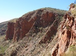
Hike Serpentine Gorge, Northern Territory, Australia
Serpentine Gorge is one of the gorges in the West MacDonnell Ranges in Australia's Northern Territory. It is located approximately 100 kilometres west of Alice Springs along the Larapinta Trail. It comprises two gorges created by a south flowing creek which has cut through two ridges of Heavitree Quarzite. The gorge is home to some rare Central Australian plants such ...
Price: $334.68