Give us feedback!


 See all

Our philosophy is simple. We want to encourage you to dream. BIG! Then we help you plan your trip, get the most out of it while you're traveling and help you share your experience with friends.
Join Now It's FREE
Dream Packages
Duration: 5 days
Price: $624.00
Price: $624.00
Duration: 6 hours
Price: $131.51
Price: $131.51
Duration: 4 hours
Price: $149.99
Price: $149.99
Duration: 4 hours
Price: $129.99
Price: $129.99
Related Categories
Dreams Still To Do
Checked-Off Dreams
Dreams Still To Do
Checked-Off Dreams
Advertisement
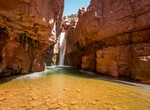
Explore Canyons
-
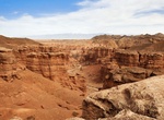
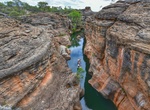
Explore Charyn Canyon & Valley of Castles, Kazakhstan
Sharyn Canyon (also known as Charyn Canyon) is a canyon on the Sharyn River in Kazakhstan, 200 kilometres (120 mi) east of Almaty, close to the Chinese border. The canyon is 80 or 90 kilometres (50 or 56 mi) in length. It is within the Sharyn River valley and is part of the Charyn National Park, which was established on 23 February 2004, and is located within the terr... -
Explore Cheddar Gorge, Somerset, England
Cheddar Gorge is a limestone gorge in the Mendip Hills, near the village of Cheddar in Somerset, England. The gorge is the site of the Cheddar show caves, where Britain's oldest complete human skeleton, Cheddar Man, estimated to be over 9,000 years old, was found in 1903. Older remains from the Upper Late Palaeolithic era (12,000–13,000 years ago) have been foun... -
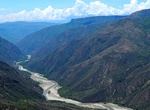
Explore Chicamocha Canyon, Chicamocha National Park, Santander, Colombia
The Chicamocha Canyon (Cañón del Chicamocha) is a steep sided canyon carved by the Chicamocha River in Colombia. With a maximum depth of 2,000 metres (6,600 ft), an area of 108,000 hectares (270,000 acres) and a length of 227 kilometres (141 mi), the canyon is the second-largest worldwide. The canyon is situated in the departments of Boyac&aacu... -
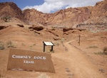
Hike Chimney Rock Loop, Capitol Reef National Park, Utah
Chimney Rock Loop in Capitol Reef National Park is 3.6 mi (5.9 km) round trip with a 590 ft (180 m) elevation gain. It's a great place to view sunsets in the park and to see panoramas of Waterpocket Fold cliffs. -
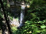
Hike to Cibecue Falls via Cibecue Creek Trail, Cibecue, Arizona
NOTE:A access permit to hike up to Cibecue Falls requires a fee per person/per day. Permits are available at the Carrizo C-Store (Sinclare gas station) which is open 6am-9pm. More information can be found at https://wmatoutdoor.org/wp_view.html?pageid=24 Cibecue Creek lies entirely within the Fort Apache Indian Reservation, within Navajo County, Arizona. The creek's w... -
Explore Clifty Falls State Park, Indiana
Clifty Falls State Park is an Indiana state park on 1,416 acres (573 ha) in Jefferson County, Indiana in the United States. It is 46 miles (74 km) northeast of Louisville, Kentucky. On Oct. 27, 1920, citizens of Madison, Indiana gave the land for the park, 570 acres (230 ha), to the state of Indiana at the suggestion of Richard Lieber. This was after a year's work by ... -
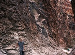
Hike Closed Canyon, Big Bend Ranch State Park, Texas
The Closed Canyon Trail is a short hike through a narrow slot canyon. The canyon entrance is visible from the parking area and access is gained by taking a short walk down a low hill, into an arroyo to the opening of the canyon. The canyon leads you toward the Rio Grande River, but river access is not possible without vertical climbing gear. The trailhead is located ... -
Explore Coal Mine Canyon, Arizona
Known for its spectacular spires, Hoodoos, cliffs, abundant fossils and narrow ravines, Coal Mine Canyon was formed from centuries of erosion of the sandstone and shale from which it was carved by mother-nature. The Canyon presents an other-worldly landscape comprised of colorful rock walls surrounding the plunging canyon that runs for 15 miles (24 kilometers) from it... -
Tour Cobbold Gorge, Queensland, Australia
Cruise the gorge then walk atop its walls and across Australia’s first fully glass bridge, exploring the incredible geological landforms and our amazing savannah wonderland on your guided tour. Please note access to Cobbold Gorge is by guided tour only, and bookings are essential. -
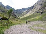
Hike Coire Gabhail (Hidden Valley), Scotland
Coire Gabhail (Corrie of the Bounty, or The Hollow of Capture) is a high level glen in the Bidean nam Bian mountain massif to the south of Glen Coe, Highland, Scotland. Its narrow entrance 230 metres (750 ft) up the hillside conceals the width of the glen beyond, and it is commonly known as the Hidden Valley or Lost Valley of Glencoe. Access from a bridge crossing the... -
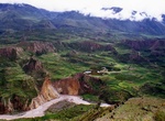
Explore Colca Canyon, Peru
Colca Canyon is a canyon of the Colca River in southern Peru. It is located about 100 miles (160 kilometers) northwest of Arequipa. It is more than twice as deep as the Grand Canyon in the United States at 4,160 m., and it is promoted as the "world's deepest canyon," although the canyon's walls are not as vertical as those of the Grand Canyon. The Colca Valley is a co... -
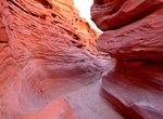
Explore Coloured Canyon, Egypt
Coloured Canyon is a rock formation on Sinai peninsula. It is a labyrinth of rocks, some of them have about 40 meters. The canyon is almost 800 meters long. The nearest town to the canyon is Nuweiba. It is about 90 km north of Dahab. -
Off-road Comb Wash Road, Utah
Comb Wash Road follows the iconic Comb Ridge. The road itself is on BLM land and is suitable for most all-terrain vehicles. Comb Wash is a long narrow valley in south central San Juan County, Utah, United States. It runs from Elk Ridge in the north approximately 35 miles (56 km) to the south, where it merges with the San Juan River at an elevation of about 4,200 feet ... -
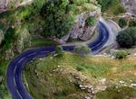
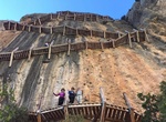
Hike Congost de Mont-Rebei Gorge, Spain
Dramatic 1,480-acre reserve on an impressive gorge along the Noguera Ribagorzana river with oak forests inhabited by eagles & vultures. Along the way you have to climb stairs, cross bridges, walk on asphalt and on dirt and stone tracks. The Congost is that it links up with the spectacular Montfalcó footbridges. -
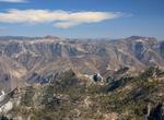
Explore Copper Canyon National Park, Mexico
Copper Canyon (Spanish: Barranca del Cobre) is a group of canyons consisting of six distinct canyons in the Sierra Tarahumara in the southwestern part of the state of Chihuahua in Mexico. The overall canyon system is larger and portions are deeper than the Grand Canyon in neighboring Arizona. The canyons were formed by six rivers which drain the western side of the Si...

Price: $277.07