Give us feedback!


 See all

Our philosophy is simple. We want to encourage you to dream. BIG! Then we help you plan your trip, get the most out of it while you're traveling and help you share your experience with friends.
Join Now It's FREE
Dream Packages
Duration: 3 days
Price: $499.72
Price: $499.72
Duration: 8 days
Price: $1251.74
Price: $1251.74
Duration: 8 hours
Price: $246.07
Price: $246.07
Dreams Still To Do
Checked-Off Dreams
Dreams Still To Do
Checked-Off Dreams
Advertisement
Explore Cycling
-
Mountain Bike 401 Trail, Crested Butte, Colorado
Trail 401 is a 15.4 mile loop trail that is one of the favorite trails in Crested Butte, Colorado. It offers spectacular views of the Gothic Valley and Mount Crested Butte. -
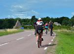
Cycle 40k
A 40 kilometer bike ride is the distance of the cycling component of an Olympic length (or International distance) triathlon and also a common target for cycling road races. Working up to a continuous ride of 40 kilometers is no small undertaking but achievable by those with basic physical fitness. Professional cyclists can cover 40 kilometers in less than 40 minutes ... -
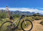
Hike or Ride 50-Year Trail, Catalina State Park, Arizona
50-Year Trail is a 8.6 miles, one-way moderate trail that is especially popular with equestrians and mountain bikers. Trail begins at the park’s Equestrian Center and follows a ridgetop 2.6 miles. A 2.2-mile Trail Link connects the 50-Year Trail with the Sutherland Trail. Or after leaving the park, the trail continues for six miles through open desert. The terra... -
Mountain Bike or Hike Aerie Loop Trail, Sedona, Arizona
This 5.0-mile loop trail near Sedona is a popular trail for mountain biking, but hikers can still enjoy some solitude during quieter times of day. Aerie Trailhead is a great place for stargazing. -
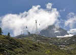
Ride Aiguille des Grands Montets Cable Car, France
The Aiguille des Grands Montets (3,295 m) is a mountain in the Mont Blanc massif in Haute-Savoie, France. Alpine glacier with a cable car offering seasonal skiing, climbing & mountain biking. -
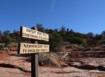
Hike Airport Loop Trails, Sedona, Arizona
The trail circles the upper slope of Airport Mesa (Table Top Mountain), described clockwise here. There is no shade until reaching the last mile where it is intermittent depending on season and time of day. From the parking area, climb to the southeast about 100 yards to the top of the small saddle. Turn right to pick up the trail which immediately bends to the left ... -
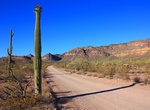
Drive or Mountain Bike Ajo Mountain Drive, Organ Pipe Cactus National Monument, Arizona
Ajo Mountain Drive is the most popular scenic drive in the monument. It is a 21 mile, mostly gravel road usually passable by normal passenger car. RVs over 24 feet are prohibited, due to the twisting and dipping nature of the road. The free Ajo Mountain Road Guidebook is available in the Kris Eggle Visitor Center. January through March a free three hour ranger guided... -
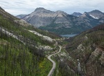
Drive or Bike Akamina Parkway, Waterton Lakes National Park, Alberta, Canada
The Akamina Parkway is a winding mountain road which starts in the Waterton townsite and runs 16 km along the Cameron Valley, ending at Cameron Lake. Along the way, stop at the national historic site commemorating Western Canada's first oil well. Crandell Lake, Lineham Falls, Rowe Lakes and Akamina Pass trailheads all are located along this road. Hiking and biking on ... -
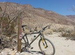
Hike or Mountain Bike Alcoholic Pass Trail, Borrego Springs, California
Alcoholic Pass Trail is a 4.6 mile out and back trail located off Lower Coyote Canyon Road north of Borrego Springs, California. The trail features beautiful wildflowers. -
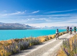
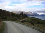
Ride Alps to Ocean Cycle Trail (Alps 2 Ocean), New Zealand
The Alps 2 Ocean Cycle Trail is a cycle trail funded as one of the projects of the New Zealand Cycle Trail. The trail extends more than 300 kilometres (190 mi) from Aoraki / Mount Cook to Oamaru on the Pacific Ocean. The Alps 2 Ocean Cycle Trail allows cyclists to experience some of the most beautiful scenery New Zealand has to offer. Suitable for all ages, the trail ... -
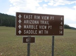
Hike or Mountain Bike Arizona Trail (North Rim), Grand Canyon National Park, Arizona
Arizona Trail on the North Rim of Grand Canyon National Park is 10 miles (16 km) one-way within the park. This section of this trail enters the park near the North Entrance and roughly parallels AZ 67 until it connects with the North Kaibab Trail along Point Sublime Trail. The Arizona Trail is marked with brown fiberglass posts with a Kaibab Plateau Trail decal near t... -
Mountain Bike Around the Mountains Cycle Trail, New Zealand
The Around the Mountains Cycle Trail has been funded as one of the projects of the New Zealand Cycle Trail. The 175 kilometres (109 mi) track begins and ends in the Queenstown Lakes District, though for most of its length it is in the Southland District. The trail begins at Kingston proceeding south to the Kingston Flyer terminus at Fairlight. It continues south on, o... -
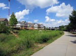
Hike or Ride Atlanta BeltLine, Atlanta, Georgia
The BeltLine (also Beltline or Belt Line) is a former railway corridor around the core of Atlanta, Georgia, under development in stages as a multi-use trail. Some portions are already complete, while others are still in a rough state but hikeable. Using existing rail track easements, the BeltLine is designed to improve transportation, add green space, and promote rede... -
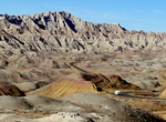
Drive or Cycle Badlands Loop Road (Hwy 240), Badlands National Park, South Dakota
The Highway 240 Badlands Loop Road, accessed from Interstate 90, is a two-lane, paved surface that takes you through the North Unit of the park. The Badlands Loop Road is open to cyclists who prefer a paved riding experience. While bicycles are allowed on the road, it is not without its hazards. The scenic road is narrow with many curves. Traffic is heavy from Memori... -
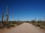
Drive or Cycle Bajada Loop Drive, Saguaro National Park, Arizona
The Bajada Loop Drive in the Tucson Mountain District (west) is a 6-mile gravel loop that includes Hohokam Road and Golden Gate Roads. Drive the loop counter clockwise since one section is one-way. Golden Gate and Hohokam Roads are dirt roads and close at sunset. Travel on Hohokam Road is not recommended for long vehicles.


Price: $571.07