Give us feedback!

Our philosophy is simple. We want to encourage you to dream. BIG! Then we help you plan your trip, get the most out of it while you're traveling and help you share your experience with friends.
Join Now It's FREE
Related Categories
Dreams Still To Do
Checked-Off Dreams
Dreams Still To Do
Checked-Off Dreams
Advertisement
Explore Day Hikes
-
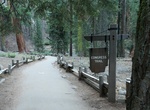
Hike Big Stump Loop Trail, Kings Canyon National Park, California
2-mile loop winds through huge stumps of logged sequoias interspersed with young sequoias, serving as a reminder of how long it takes to grow these giant trees and how logging affected them. The Mark Twain Stump has a unique story to tell. In 1891, while lumbermen were cutting other sequoia trees for grapevine stakes, lumber, and shake shingles, the Mark Twain Tree wa... -
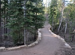
Hike or Ride Bridle Trail, Grand Canyon National Park, Arizona
The Bridle Trail 1.2 miles (2 km) one-way trail on the North Rim follows the road as it connects the Grand Canyon Lodge with the North Kaibab Trailhead. Hike or bicycle this hard-packed trail. Pets on leash are permitted. -
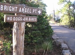
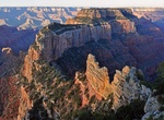
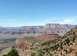
Hike to Bright Angel Point (Bright Angel Trail), Grand Canyon National Park, Arizona
The hike to Bright Angel Point on the Bright Angel Trail is a great day hike if your on the North Rim of the Grand Canyon National Park. The paved trail leads to a spectacular view of the canyon. The view confirms the tremendous uplift that has occurred, leaving the canyon’s North Rim 1,000 feet/300 meters higher than the South Rim. The trail is 0.5 mile (0... -
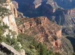
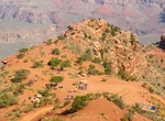
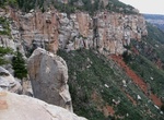
Hike Cape Final Trail, Grand Canyon National Park, Arizona
Cape Final Trail is a 4.0 mile (6.4 km) round-trip hiking trail along the North Rim of Grand Canyon National Park. It takes approximately 2 hours round-trip hiking time and has an elevation gain of 210 ft (64 m). Cape Final is at an elevation of 7,916 feet (2,413 m) and overlooks the eastern Grand Canyon from Nankoweap to the Unkar Creek Delta. It also shows how ... -
Hike Cape Royal Trail, Grand Canyon National Park, Arizona
The Cape Royal Trail is a 1 mile (1.6 km) round trip hiking trail on the North Rim of the Grand Canyon National Park. Cape Royal on the North Rim offers a 270 degree panorama views up, down, and across the canyon. This popular viewpoint is accessible via a paved, level trail. With seemingly unlimited vistas to the east and west, it is popular for both sunrise and... -
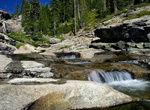
Hike Cathedral Lakes Trail, Yosemite National Park, California
The Cathedral Lakes are two lakes located In Yosemite National Park, California. There is a 7 miles (11 km) round trip hike of from the trailhead in Tuolumne Meadows. The lakes are situated 1.6 km (1 mi) southwest of Cathedral Peak and 3.2 km (2 mi) east-northeast of Tenaya Lake. The lower lake is located at elevation 9,288 feet (2,831 m), while the upper lake is loc... -
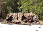
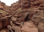
Hike Cathedral Wash, Grand Canyon National Park, Arizona
Cathedral Wash is is a 3 mi (4.8 km) roundtrip (1.5-3 hours) hike near Lees Ferry, Arizona that goes down to the Colorado River. Hike begins in Glen Canyon NRA and ends in Grand Canyon National Park. Descend into the rocky wash, traveling through the Kaibab Limestone and Toroweap Formations of the Grand Canyon Group. Many interesting formations and fossils may be seen... -
Hike to Cedar Ridge (South Kaibab Trail), Grand Canyon National Park, Arizona
The hike from South Kaibab Trailhead to Cedar Ridge has a 1,140 feet (347 m) elevation drop and is 1.5 miles (2.4 km) one-way. Stop at Ooh-Aah Point along the way. The trailhead is located at end of Yaki Point Road. Allow 3-4 hours to do the hike. Check out the ranger guided hikes to Cedar Ridge on the South Kaibab Trail. Offered daily during the summer. The hike... -
Hike or Ride Horses to Chilnualna Falls, Yosemite National Park
Chilnualna Falls is a series of waterfalls totaling 690 feet (210 m), located on Chilnualna Creek in the southern section of Yosemite National Park. If you are staying in Wawona, or have entered Yosemite through the South Entrance, then Chilnualna Falls is on your way down to the valley. The falls are a popular horseback riding destination. Chilnualna Falls consi... -
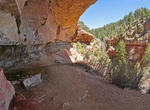
Hike Cliff Spring Trail, Grand Canyon National Park, Arizona
The Cliff Spring Trail is a 1.0 mile (1.6 km) round-trip hiking trail located on the North Rim of the Grand Canyon National Park, Arizona. It takes approximately 1 hour round-trip hiking time. The trail meanders down a forested ravine and ends where a chest-high boulder rests under a large overhang. The spring is on the cliff side of the boulder. President Teddy ... -
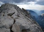
Summit Clouds Rest, Yosemite National Park
Clouds Rest is a mountain in Yosemite National Park east northeast of Yosemite Village, California. Although there are many peaks in the park having far greater elevation, Clouds Rest's proximity to the valley gives it a very high degree of visual prominence. The summit can be reached by a 7.2-mile (11.6 km) trail hike from Tioga Pass Road or a 9.4-mile (15.1 km) trai... -
Hike to Coconino Overlook & Supai Tunnel (North Kaibab Trail), Grand Canyon National Park, Arizona
Do a day hike on the North Kaibab Trail Coconino Overlook and Supai Tunnel. Coconino Overlook is a 1.5 miles (2.4 km) round-trip hike and continuing to Supai Tunnel makes it a 4 miles (6.5 km) round-trip hike. Both of these stops will display the canyon's rich natural beauty and immense size. Coconino Overlook has 790ft (240m) from rim. Water available mid-May to... -
Hike to Coconino Saddle and/or Horseshoe Mesa (Grandview Trail), Grand Canyon National Park, Arizona
Day hikers can take the Grandview Trail to one of the following destinations: Coconino Saddle, 2.2 miles (round trip), 1,190 feet (360) elevation gain Horseshoe Mesa, 6.4 miles (round trip), 2,600 feet (793 m) elevation gain This is a very steep trail making the trail conditions tougher than the Bright Angel and South Kaibab Trails. For experienced desert hiker... -
Hike Congress Trail, Sequoia National Park, California
Congress Trail is a 2.7 mile round-trip lollipop-shaped trail on a gentle, paved incline. It begins near the General Sherman Tree, the largest living tree on Earth. Along the path, you'll also see excellent examples of mature sequoias, including the House and Senate groups, and the President Tree. For accessible access to the Congress Trail and General Sherman Tree, p... -
Hike Four Mile Trail, Yosemite Valley
Four Mile Trail is a moderate to strenuous trail leading from Yosemite Valley to Glacier Point. The trail begins at the valley floor west of the Swinging Bridge recreation area, and climbs the south side 4.8 miles (7.7 km) up to Glacier Point, an elevation change of 3,200 feet (1,000 m). Four Mile Trail was originally constructed in 1872 and was 4 miles (6.4 km) ...