Give us feedback!

Our philosophy is simple. We want to encourage you to dream. BIG! Then we help you plan your trip, get the most out of it while you're traveling and help you share your experience with friends.
Join Now It's FREE

Related Categories
Dreams Still To Do
Checked-Off Dreams
Dreams Still To Do
Checked-Off Dreams
Advertisement
Explore Fishing
-
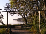
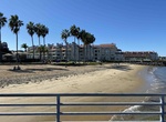
Fish at Cama Beach State Park, Island County, Washington
Cama Beach State Park is a Washington state park facing Saratoga Passage on the southwest shore of Camano Island in Island County, preserving the site of a renovated and modernized, 1930s-era auto court and fishing resort. Park activities include boating, crabbing, scuba diving, fishing, swimming, hiking on 15 miles of trails, wildlife viewing, and horseshoes. A mile-... -
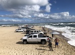
Fish at Cape Point, Hatteras Island, North Carolina
Cape Point is the easternmost beach of Hatteras Island, meaning it stretches out into the ocean further than any other beach in the Outer Banks. It's anexcellent fishing spot. -
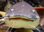
Noodle or Handfish for Catfish
Noodling is fishing for catfish using only bare hands, practiced primarily in the southern United States. The noodler places his hand inside a discovered catfish hole. Many other names, such as catfisting, grabbling, graveling, hogging, dogging, gurgling, tickling and stumping, are used in different regions for the same activity. The term "noodling", although today us... -
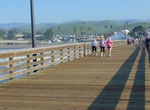
Visit Cayucos Pier, Cayucos, California
Cayucos Pier represents the very best of Highway 1. Just steps from the sand and a walkable downtown. -
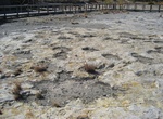
Visit Clayton Lake State Park, New Mexico
Clayton Lake State Park is a state park of New Mexico, United States, featuring a 170-acre (69 ha) recreational reservoir and a fossil trackway of dinosaur footprints. It is located 15 miles (24 km) north of Clayton, close to New Mexico's border with Colorado, Oklahoma, and Texas. The park is accessed via New Mexico State Road 455. The landscape is characterized by ro... -
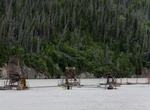
Stay at Clearwater Island Lodge, Tiwi Islands, Northern Territory
A true cultural fishing experience like no other you’ll experience deserted beaches. Get immersed in the rich culture & enjoy the best fishing here at our remote fishing lodge. Learn about local wildlife & the populations of the endangered Olive Ridley. -
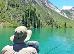
Fish Convict Lake, California
Convict Lake is known for its fishing, including Rainbow trout, German brown trout, and a species of sucker fish. Due to the high demand of fishing in the lake and stream, the lake is stocked once a week during the summer with rainbow trout, supplied by nearby hatcheries. -
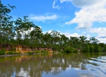
Fish Copper River, Wrangell–St. Elias National Park, Alaska
The Copper River or Ahtna River, Ahtna Athabascan ‘Atna’tuu ([ʔatʰnaʔtʰuː]), "river of the Ahtnas", Tlingit Eeḵhéeni ([ʔìːq.híː.nì]), "river of copper", is a 290-mile (470 km) river in south-central Alaska in the United States. It drains a large region of the Wrangell Mountains and Chugach Mountains into the Gulf of Alaska. It i... -
Visit Coronado Ferry Landing Park, Coronado, California
Catch the ferry from Downtown San Diego to the idyllic Coronado Landing Park. This popular destination offers visitors a picture-perfect scene of San Diego's glimmering skyline and dynamic waterfront, with an eclectic mix of shops and restaurants. It's a Port of San Diego park. Dogs are allowed on leash in all Port of San Diego parks. -
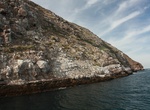
Dive & Fish Coronado Islands, Baja California, Mexico
The Coronado Islands (Islas Coronado or Islas Coronados) are a group of four islands off the northwest coast of the Mexican state of Baja California near the US Border. Battered by the wind and waves, they are largely infertile and uninhabited except for a small military detachment and a few lighthouse keepers. The islands lie between 15 and 19 miles south of the entr... -
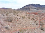
Off-road to Cottonwood East (Pot Cove), Arizona
This road is great as a break from the hustle and bustle of Vegas, and an excellent place to enjoy stunning views. Entirely dirt, Cottonwood Road’s eastern half is smooth and well-traveled but still requires 4WD. Once you climb up into the Black Mountains, the terrain and road get more rough and washboard-like before descending toward Lake Mohave. Look up around... -
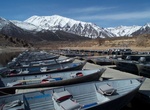
Fish Crowley Lake, California
Crowley Lake is one of the only locations in the Eastern Sierra where visitors can drive up to the water’s edge. With a shoreline that adds up to 45 miles, fishing, boat rentals, and seasonal watersports including waterskiing and wakeboarding are popular with anglers and sightseers. Fishing season is the last Saturday in April through November 15 every year. A... -
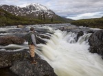
Explore Delta Wild and Scenic River, Alaska
The Delta River watershed extends from the Upper Tangle Lakes downstream to Black Rapids; the Tangle River flows through and connects the lakes (150,000 acres, 160 miles of streams, and 21 lakes) before finding its way to the Delta River. The Delta then flows north to join the Tanana River and, eventually, the Yukon River. The topography in the vicinity of the lower D... -
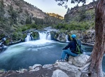
Explore Deschutes Wild and Scenic River, Oregon
The Deschutes River is located in central Oregon. It provides much of the drainage on the eastern side of the Cascade Range on its way to its confluence with the Columbia River. The Deschutes was an important resource for thousands of years for Native Americans and in the 19th century for pioneers on the Oregon Trail. The river runs through a deep rimrock-lined canyon... -
Explore Diamond Lake, Oregon
Diamond Lake is a natural body of water in the southern part of the U.S. state of Oregon. It lies near the junction of Oregon Route 138 and Oregon Route 230 in the Umpqua National Forest in Douglas County. It is located between Mount Bailey to the west and Mount Thielsen to the east; it is just north of Crater Lake National Park. Anglers often fish by boat near Silent...
Price: $947.75