Give us feedback!

Our philosophy is simple. We want to encourage you to dream. BIG! Then we help you plan your trip, get the most out of it while you're traveling and help you share your experience with friends.
Join Now It's FREE


Related Categories
Dreams Still To Do
Checked-Off Dreams
Dreams Still To Do
Checked-Off Dreams
Advertisement
Explore Islands (Cool Climate)
-
Walk to Modo Island via Jindo's Sea Way, South Korea
Modo Island is a small island in Jindo County, South Jeolla Province, South Korea, just off the southwest corner of the Korean peninsula. It is located to the south-east of Jindo Island and is about 1.1 km (0.68 mi) long and 300 m (980 ft) wide. The tide-related sea level variations result in a land pass 2.9 km (1.8 mi) long and 10–... -
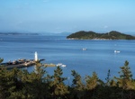
Visit Monhegan Island, Maine
Monhegan is an island in the Gulf of Maine located in Lincoln County, Maine, United States. A plantation, a minor civil division in the state of Maine falling between unincorporated area and a town, it is located about 12 nautical miles (22 km) off the mainland. The population was 64 at the 2020 census. The plantation comprises its namesake island and the uninhabited ... -
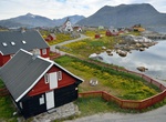
Visit Nanortalik, Greenland
Nanortalik is a town in Nanortalik Island, southern Greenland. With 1,072 inhabitants as of 2024, it is the eleventh-largest town in the country. The name Nanortalik means "Place of Polar Bears" or "Place Where the Polar Bears Go". Because of its location, this area was one of the first parts of Greenland settled by the Norse and one of the last settled by the I... -
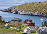
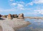
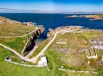
Visit Niapiskau Island, Mingan Archipelago National Park Reserve, Quebec, Canada
Niapiskau is famous for its many monoliths, including the celebrated Bonne Femme. Hike through a short trail to a lookout offering an unrestricted view of the sea. -
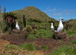
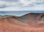
Visit Nightingale Island, Tristan da Cunha, UK
Nightingale Island is an active volcanic island in the South Atlantic Ocean, 3 square kilometres (1.2 sq mi) in area, part of the Tristan da Cunha group of islands. They are administered by the United Kingdom as part of the overseas territory of Saint Helena, Ascension and Tristan da Cunha. Nightingale Island is part of the Nightingale Islands, which also includes isl... -
Explore Nólsoy Island, Faroe Islands
Nólsoy is an island and village in central Faroe Islands, 4 km east of the capital Tórshavn in Streymoy. Nólsoy is the lowest of the Faroes; the highest point is Eggjarklettur (372 m) on the mountainHøgoyggj. The southern coast contains two capes, each with a lighthouse (Øknastangi on the south-east, Borðan on the south). The lig... -
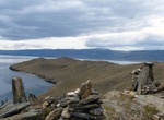
Visit Ogoy Island, Lake Baikal, Russia
Ogoy is the largest island in the Maloe More strait of Lake Baikal. It has an elongated shape, 2.9 km (1.8 mi) in length and 0.6 km (0.37 mi) in width. It is located between the Cape Shara-Shulun on the west coast of the Olkhon Island and Kurminskiy Bay on the western shore of Lake Baikal. The island is uninhabited. Vegetation on the island is scarce, mainly grasses a... -
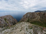
Visit Olkhon Island, Lake Baikal, Siberia
Olkhon is the third-largest lake island in the world. It is by far the largest island in Lake Baikal in eastern Siberia, with an area of 730 km2 (280 sq mi). Structurally, it constitutes the southwestern margin of the Academician Ridge. The island measures 71.5 km (44.4 mi) in length and 20.8 km (12.9 mi) in width. There are two versions regarding the origin of the na... -
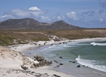
Visit Owey Island, Donegal, Ireland
Owey Island (meaning 'Cave' ) is an island off the coast of west County Donegal, Ireland. The island is around 120 hectares (300 acres) in area. It lies off the Donegal coast near Kincasslagh. The island's highest hill, Moylemore, has a summit elevation of 102 m. The buildings of the island are located on its southern part, the northern part being rocky and expos... -
Visit Pebble Island, West Falkland
Pebble Island is one of the Falkland Islands, situated north of West Falkland. It is possibly named after the peculiarly spherical pebbles found at its western tip. The island, the fifth largest in the Falklands archipelago, stretches for 35 kilometres (22 mi) and about 6 kilometres (4 mi) at its widest point, with a total area of 103.36 km2 (39.91 sq mi). Its three h... -
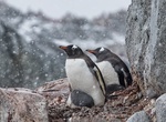
Visit Penguin Island (South Shetland Islands), Antarctica
Penguin Island (also known as Georges Island, Île Pingouin, Isla Pingüino, and Penguin Isle) is one of the smaller of the South Shetland Islands of Antarctica. Penguin Island was sighted in January 1820 by a British expedition under Edward Bransfield, and so named by him because penguins occupied the shores of the island. The island, which is ice-free and o... -
Visit Petermann Island, Graham Land, Antarctica
Petermann Island is a small, low and rounded island, lying off the northwest coast of Kyiv Peninsula in Graham Land, Antarctica, a short distance south of Booth Island and the Lemaire Channel. It is a popular tourist destination. The island is 1.8 km (1.1 mi) long and 1.2 km (0.75 mi) across. It rises steeply to elevations of up to 250 m (... -
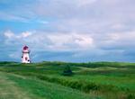
Explore Prince Edward Island National Park, Canada
Prince Edward Island National Park is a National Park located on Prince Edward Island. Situated along the island's north shore, fronting the Gulf of St. Lawrence, the park measures approximately 60 km in length and ranges from several hundred metres to several kilometres in width. Established in 1937, the park's mandate includes the protection of many broad sand beach... -
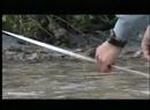
Fly Fish at Princess Royal Island, British Columbia, Canada
Princess Royal Island is a wild, mostly uninhabited land mass located among the isolated inlets, passageways and islands of the forgotten coast of Western Canada. The region is extremely remote, reachable only by seaplane or boat, 500 kilometers north of Vancouver, BC and 200 kilometers south of Prince Rupert. The island is within the perimeter of the Great Bear Rainf... -
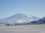
Visit Ross Island, Antarctica
Ross Island is an island formed by four volcanoes in the Ross Sea near the continent of Antarctica, off the coast of Victoria Land in McMurdo Sound. Ross Island lies within the boundaries of Ross Dependency, an area of Antarctica claimed by New Zealand. Sir James Ross discovered it in 1840, and it was later named in honour of him by Robert F. Scott. Ross Island was th...
Price: $128.25