Give us feedback!


 See all

Our philosophy is simple. We want to encourage you to dream. BIG! Then we help you plan your trip, get the most out of it while you're traveling and help you share your experience with friends.
Join Now It's FREE
Dream Packages
Duration: 3 days
Price: $873.68
Price: $873.68
Duration: 15 hours
Price: $149.00
Price: $149.00
Duration: 2 days
Price: $300.00
Price: $300.00
Duration: 6 hours
Price: $108.97
Price: $108.97
Related Categories
Dreams Still To Do
Checked-Off Dreams
Dreams Still To Do
Checked-Off Dreams
Advertisement
Explore Islands
-
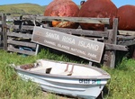
Visit Santa Rosa Island, Channel Islands National Park, California
Santa Rosa Island is the second largest of the Channel Islands of California at 53,195 acres (215.27 km² or 83.118 sq mi). It is part of Channel Islands National Park. Highest peak is Vail Peak, at 1,589 feet (484 m). Santa Rosa is located about 26 miles (42 km) off the coast of Santa Barbara, California in Santa Barbara County. It is occupied by rolling hills, d... -
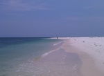
Visit Santa Rosa Island, Florida
Santa Rosa Island is a 40-mile (64 km) barrier island located in the U.S. state of Florida, thirty miles (50 km) east of the Alabama state border. The communities of Pensacola Beach, Navarre Beach, and Okaloosa Island are located on the island. On the northern lee side, of the island, are Pensacola Bay on the west (see map) and Choctawhatchee Bay on the east, joined t... -
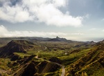
Visit Santiago, Cape Verde
Santiago (Portuguese for “Saint James”), orSantiaguin Cape Verdean Creole, is the largest island of Cape Verde, its most important agricultural centre and home to half the nation’s population. Santiago is located between the islands of Maio (40 kilometres (25 miles) west) and Fogo (50 kilometres (31 miles) east) and is one of the Sotavento. It w... -
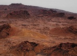
Explore Santiago Island, Galápagos
Santiago Island is an island of the Galápagos Islands. It is also known as San Salvador, named after the first island discovered by Columbus in the Caribbean Sea (see San Salvador Island), or as James Island. The island, which consists of two overlapping volcanoes, has an area of 585 km² and a maximum altitude of 907 meters, atop the northwestern shield vo... -
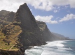
Visit Santo Antão, Cape Verde
Santo Antão (Portuguese for "Saint Anthony"), orSontontonin Cape Verdean Creole, is the westernmost and largest of the Barlavento islands of Cape Verde. The nearest main island is São Vicente to the southeast, separated by a channel named Canal de São Vicente. It is the westernmost large island in Cape Verde and the continent of Africa, and the se... -
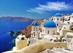
Visit Santorini Island (Thíra), Greece
Walking through the narrow streets of the picturesque Greek Island of Santorini you will likely smell a heavenly mixture of olive oil, mint, and wine in the air. The islands whitewashed houses framed by bougainvillea spill down the rim of this ancient volcanic crater. You’d never really know that a volcano last erupted on this island in 1956. Though some of the ... -
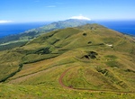
Visit São Jorge Island, Azores
São Jorge is a Portuguese island in the central Azorean archipelago of Portugal. It is separated from its nearest neighbors (Pico and Faial islands) by a 15 km strait (consequently, the three islands are sometimes referred to colloquially as the "Triangle" group or just "The Triangle"). São Jorge is a relatively long thin island with tall cliffs, and whe... -
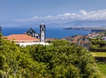
Visit São Miguel Island, Azores, Portugal
São Miguel Island is also referred to locally as "The Green Island", is the largest and most populous island in the Portuguese archipelago of the Azores. The island covers 760 km2 (290 sq mi) and has around 140,000 inhabitants, with 45,000 of these people resident in the largest city in the archipelago: Ponta Delgada. São Miguel is bisected by many fault... -
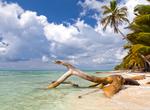
Visit Saona Island, Dominican Republic
Saona Island is a tropical island located a short distance from the mainland on the south-east tip of the Dominican Republic. It is a government protected nature reserve and is part of East National Park. It is a popular destination for tourists from all over the Dominican Republic, who arrive in fleets of catamarans and small motorboats on organized excursions every ... -
Visit São Tomé and Príncipe
São Tomé and Príncipe, officially the Democratic Republic of São Tomé and Príncipe, is a Portuguese-speaking island country in the Gulf of Guinea, off the western equatorial coast of Central Africa. It consists of two archipelagos around the two main islands of São Tomé and Príncipe, about 150 km (93.21 mi... -
Visit São Tomé Island, São Tomé and Príncipe
São Tomé Island, at 854 km2 (330 sq mi), is the largest island of São Tomé and Príncipe and is home in May 2018 to about 193,380 or 96% of the nation's population. The island is divided into six districts. It is located 2 km (1¼ miles) north of the equator. São Tomé Island is about 48 kilometres (30 miles) long (... -
Visit São Vicente, Cape Verde
São Vicente (Portuguese for "Saint Vincent"), also Son Visent or Son Sent in Cape Verdean Creole, is one of the Barlavento islands of Cape Verde. It is located between the islands of Santo Antão and Santa Luzia, with the Canal de São Vicente separating it from Santo Antão. The island is roughly rectangular in shape with a surface area of ca... -
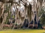
Visit Sapelo Island, Georgia
Sapelo Island /ˈsæpəloʊ/ is a state-protected barrier island located in McIntosh County, Georgia. The island is accessible only by aircraft or boat; the primary ferry comes from the Sapelo Island Visitors Center in McIntosh County, Georgia, a seven-mile (11 km), twenty-minute trip. It is the site of Hog Hammock, the last known Gullah community. It is illegal to ... -
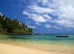
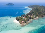
Visit Sapi Island, Tunku Abdul Rahman National Park, Sabah, Malaysia
Sapi Island, literally known as "Cow Island" in Malay is just off the south-western tip of Gaya Island. The 25-acre (10 ha) island features one of the nicest beaches in the park and most popular with tourists for snorkelling and scuba diving. Between 10 am and 4 pm the island gets quite busy with foreign tourists but after the l... -
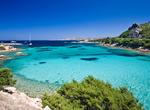
Visit Sardinia
Sardinia (Sardegna) is the second-largest island in the Mediterranean Sea (after Sicily and before Cyprus). It is an autonomous region of Italy, and the nearest land masses are (clockwise from north) the French island of Corsica, the Spanish Balearic Islands, and the Italian Peninsula, Sicily, Tunisia. Megalithic building structures called nuraghe are scattered in gre...
Price: $2401.73