Give us feedback!


 See all

Our philosophy is simple. We want to encourage you to dream. BIG! Then we help you plan your trip, get the most out of it while you're traveling and help you share your experience with friends.
Join Now It's FREE
Dream Packages
Duration: 11 hours
Price: $240.19
Price: $240.19
Duration: 2 days
Price: $337.00
Price: $337.00
Duration: 10 hours
Price: $133.00
Price: $133.00
Duration: 12 hours
Price: $120.00
Price: $120.00
Related Categories
Dreams Still To Do
Checked-Off Dreams
Dreams Still To Do
Checked-Off Dreams
Advertisement
Explore Lakes or Bays
-
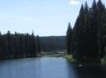
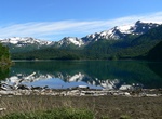
Explore Clear Lake, Oregon
Clear Lake is a mountain lake 86 mi (138 km) northeast of Eugene, Oregon, United States in Linn County. It has two main bodies connected by a bottleneck. The lake is primarily fed by snow runoff from nearby Mount Washington and the surrounding areas. The runoff filters through underground caverns for more than 20 years before emptying into Clear Lake. The lake is also... -
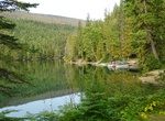
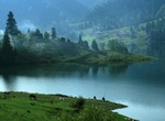
Explore Clearwater Lake, Wells Gray Provincial Park, BC, Canada
Clearwater Lake is one of six large lakes in Wells Gray Provincial Park in east-central British Columbia, Canada,. The Clearwater River enters the lake at its north end, flowing from Hobson Lake and Azure Lake, and also drains the lake. There are several small streams that flow into Clearwater Lake, but it has no significant tributaries. The basin occupied by Clearwa... -
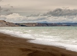
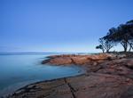
Visit Clifford Bay Beach, New Zealand
Clifford Bay is a bay in the northeast of the South Island of New Zealand, in the Marlborough Region. It lies between Cloudy Bay to the northwest, and Cape Campbell. The bay's most notable feature is the solar salt extraction works at Lake Grassmere, close to the southern end of the bay. Since the 1920s, there have been various proposals for an inter-island port and f... -
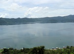
Explore Coatepeque Caldera, El Salvador
Coatepeque De Coatepeque ("at the snake hill") is a volcanic caldera in El Salvador in Central America. The caldera was formed during a series of major rhyolitic explosive eruptions between about 72,000 and 57,000 years ago. Since then, basaltic cinder cones and lava flows formed near the west edge of the caldera, and six rhyodacitic lava domes have formed. The younge... -
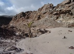
Visit Cocoanut Bay, Ascension Island, St. Helena
Cocoanut Bay is located on the southern side of Ascension Island. The name was misspelled when originally named. -
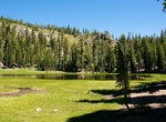
Hike to Cold Boiling and Crumbaugh Lakes, Lassen Volcanic National Park, California
The hike to Cold Boiling Lake is pretty level and then it decends to Crumbaugh Lake. The trail then descends a steep grade to Mill Creek Falls. The hike starts at Kings Creek Picnic Area. Cold Boiling Lake is 0.8 mile; Crumbaugh Lake is 1.3; Mill Creek Falls is 3.0; Southwest Campground is 4.6; all distances one way. From Mill Creek Falls the trail follows a steady i... -
Explore Coldwater Lake, Washington State
Coldwater Lake is a barrier lake on the border of Cowlitz County and Skamania County, Washington in the United States. The lake was created during the 1980 eruption of Mount St. Helens, which blocked its natural outlet, Coldwater Creek, with volcanic debris. It is one of several lakes in the area that were created or otherwise enlarged by the eruption. The lake runs f... -
Visit Coles Bay, Tasmania, Australia
Coles Bay is an Australian town on the east Coast of Tasmania 192 km north-east of Hobart and 209 km south-east of Launceston, being the main entrance point for visitors to the Freycinet National Park. It has a population of about 470 people including the surrounding area, but a large number of tourists visit the area for its scenery and outdoor activities, which incl... -
Visit Colibița Lake, Romania
Colibița is a tourist lake is located in Romania. -
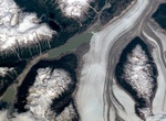
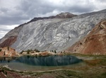
Visit Colonia Glacier & Lake Cachet II, Chile
Colonia Glacier (Glaciar Colonia Ventisquero Colonia) is a valley glacier located in the Northern Patagonian Ice Field, Chile. The glacier spills out to the southeast from an ice plateau north of Cerro Arenales and has its terminus about 4 km (2.5 mi) from Colonia Lake. Colonia Glacier dams two lakes; Cachet II and Arco Lake. The ice dam containing the waters of Cache... -
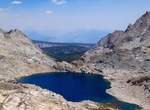
Hike to Columbine Lake, Sequoia National Park, California
Columbine Lake with its intense blue water is one of the most scenic destinations in the entire Sierra Nevada. This difficult hike starts in Sequoia National Park’s Mineral King Valley and goes over rocky 11,630-foot Sawtooth Pass. Columbine Lake (10,800 ft.) sits in a granite bowl surrounded by a circular ridge of jagged granite peaks. -
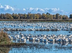
Explore Colusa National Wildlife Refuge, California
Colusa National Wildlife Refuge is one of six refuges in the Sacramento National Wildlife Refuge Complex located in the Sacramento Valley of north-central California. The refuge is located in Colusa County. It is around 70 miles (110 km) north of metropolitan Sacramento. The 4,507-acre (18.24 km2) refuge primarily consists of intensively managed wetland impo... -
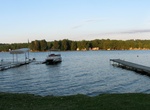
Explore Conesus Lake, New York
Conesus Lake is a Finger Lake in Livingston County in western New York state. The fifth smallest of eleven, it is located off Interstate 390 about 15 miles (24 km) south of Interstate 90. Conesus Lake is eight miles (13 km) long, with a maximum depth of 66 feet (20 m). It flows south to north, from its inlet in the Town of Conesus to its outlet, Conesus Creek, in Lake... -
Explore Conguillío Lake, Chile
Conguillío Lake is a lake located in the La Araucanía Region of Chile, within the Conguillío National Park. The lake was formed by the damming of the Trufultruful River caused by a lava flow from the Llaima volcano. -
Hike Convict Canyon Trail to Mildred Lake, California
Convict Creek Trail to Mildred Lake is a 9.1 mile out and back trail located near Mammoth Lakes, California. It features a great forest and is best used from June until September. One of the nicest places to go in the eastern sierra (if you're into rocks) is Convict canyon. it's an easy drive to get there, and there's a pretty and not very long trail that goes up the...

Price: $228.00