Give us feedback!

Our philosophy is simple. We want to encourage you to dream. BIG! Then we help you plan your trip, get the most out of it while you're traveling and help you share your experience with friends.
Join Now It's FREE
Dreams Still To Do
Checked-Off Dreams
Dreams Still To Do
Checked-Off Dreams
Advertisement
Explore Landmarks (Natural)
-
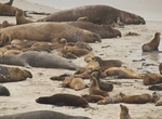
Visit Adams Cove, San Miguel Island, California
The cove’s broad sandy expanse of beach is home to the largest pinniped rookery in the United States. Here, more than 70,000 California sea lions, 50,000 Northern elephant seals, and 5,000 Northern fur seals congregate annually during breeding and pupping seasons. This place name appears on the San Miguel Island West topographic map. The 471-foot steel-hulled oi... -
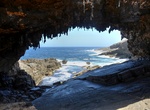
See Admirals Arch, Kangaroo Island, South Australia
Admirals Arch is one of Kangaroo Island's most impressive and unusual natural landmarks. The boardwalk leading to the Admirals Arch is nearly as scenic as the landmark itself. -
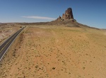
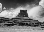
See Agathla Peak (El Capitan), Arizona
Agathla Peak (El Capitan) is a peak south of Monument Valley, Arizona, which rises over 1500 feet (457 meters) above the surrounding terrain. It is 7 miles (11 km) north of Kayenta and is visible from U.S. Route 163. The English designationAgathlais derived from the Navajo nameaghaałą́meaning 'much wool', apparently for the fur of antelope and deer accumulating on the... -
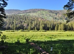
Camp at Agnew Meadows Campground, Mammoth Lakes, California
Agnew Meadows Campground includes a Family Campground, a Group Campground, and an Equestrian Campground. It is located in the Reds Meadow Valley, just west of Mammoth Lakes, California. Popular with large families, this campground provides access to some of the most spectacular wilderness in the Sierra and many outdoor activities such as horseback riding, fishing, hi... -
Take a dip at Agua Caliente, Baja California Sur, Mexico
Visit the hot springs near the village of Agua Caliente (aka Los Manantiales) in central East Cape region in Baja California Sur, Mexico near the town of Santiago. The hot spring is in a nearby canyon about 7 km, (4 miles) west of the village. The springs have been channeled into a concrete tub to make it easy to take a dip. Camping is permitted in the canyon. Ask dir... -
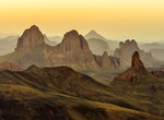
Explore Ahaggar National Park (Hoggar Mountains), Algeria
The Hoggar Mountains are a highland region in the central Sahara in southern Algeria, along the Tropic of Cancer. The mountains cover an area of approximately 550,000 km. This mountainous region is located about 1,500 km (930 mi) south of the capital, Algiers. The area is largely rocky desert with an average elevation of more than 900 m (3,000 ft) ... -
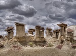
Explore Ah-Shi-Sle-Pah Wilderness, New Mexico
Ah-Shi-Sle-Pah Wilderness is located in San Juan County, New Mexico, between Chaco Canyon and the De-Na-Zin Wilderness. The wilderness has multicolored badlands, sandstone hoodoos, petrified wood and dinosaur bones, similar to those found in the nearby Bisti Badlands and De-Na-Zin Wilderness. BLM closed the jeep trail to this point, which overlooks the Ahshislepah Wil... -
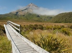
See Ahukawakawa Swamp, Egmont National Park, New Zealand
The Ahukawakawa Swamp is an area of sphagnum bog in Egmont National Park in the Taranaki Region of New Zealand. It was formed approximately 3,500 years ago and is of particular interest to botanists. Over 260 species of higher plant have been recorded there. The area of the swamp is approximately 1 km2. The swamp sits at an altitude of 920 metres and lies between the ... -
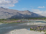
Visit Ahuriri Conservation Park, South Island, New Zealand
Ahuriri Conservation Park is a protected area of 49,000 hectares including tussock grasslands, forest, and river habitat, located in Canterbury, South Island, New Zealand, and centred around the headwaters of the Ahuriri River. The park includes trails and huts. The mountains, forests, tussock lands and river valleys are used for tramping, fishing kayaking, horse ridi... -
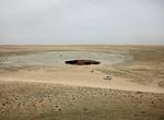
Explore Air Batu Lake, Sumatra, Indonesia
Air Batu is an old entrenchment of the mining that became a lake. It's located in Banyuasin, South Sumatra and is commonly visited by tourists and locals. -
See Airport Tower, Canyonlands National Park
Airport Tower is located in Canyonlands National Park and can be seen from White Rim Road. -
Visit Akjagaýa Depression, Turkmenistan
Akjagaýa is a depression in the northwest Karakum Desert. It is located to the south of Sarykamyska Valley. It is about 50 km long and 6 km wide. The lowest point is 81 m below sea level, making it the lowest point in Turkmenistan. -
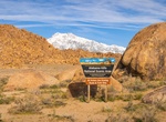
Explore Alabama Hills, California
Alabama Hills is known for its rock formations that have atracted movie makers, photographers and tourist from all over the world. The hills are located in Inyo County, California. Explore the hills by cara, bike or hiking. Since the early 1920's, move stars such as Gen Autry, Hopalong Cassidy and the Lone Ranger have been shooting it out with outlaws in the Alabama H... -
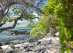
Hike Ala Kahakai National Historic Trail, Big Island, Hawaii
Ala Kahakai National Historic Trail is a 175-mile (282 km) long trail located on the island of Hawaiʻi. It is not yet a continuous "trail", but can be accessed at several broken segments along the coastline of the Big Island. The trail was established to access the traditional Ancient Hawaiian culture along with the natural geology of the island. The trail was establ... -
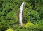
See Alalum Falls, Mindanao Island, Philippines
Alalum Falls is located along the Sayre Highway and less than a kilometer distance from the Municipal Hall. Its imposing grandeur can easily be seen by travelers on motor vehicles. It is approximately 148 feet (45 m) high. However, due to ongoing public constructions, it may be difficult to catch a glimpse of the attraction. But the falls will be open to public again ...