Give us feedback!


 See all

Our philosophy is simple. We want to encourage you to dream. BIG! Then we help you plan your trip, get the most out of it while you're traveling and help you share your experience with friends.
Join Now It's FREE
Dream Packages
Duration: 9 hours
Price: $88.47
Price: $88.47
Duration: 8 hours
Price: $246.07
Price: $246.07
Duration: 13 hours 30 minutes
Price: $572.77
Price: $572.77
Duration: 12 hours
Price: $135.99
Price: $135.99
Related Categories
Dreams Still To Do
Checked-Off Dreams
Dreams Still To Do
Checked-Off Dreams
Advertisement
Explore Mountains
-
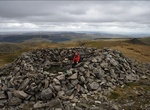
See View from Pico do Arieiro, Madeira
Pico do Arieiro, at 1,818 m high (5965 feet), is Madeira island's third highest peak. Most days, visitors can stand and look down on the clouds. The air is fresh and clear and the sun is very bright. On a clear day it is possible to see the neighbouring island of Porto Santo, 30 miles to the north. The footpath northwards towards Pico Ruivo is an important tourist att... -
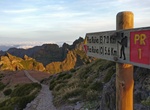
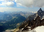
Hike to Pico Ruivo, Madeira
Pico Ruivo is the highest peak on the Madeira Islands. It can be reached only by foot, usually either from Pico do Arieiro (3rd highest) after a strenuous hike, or from Achada do Teixeira with a shorter, easier trail. There is an additional trail leading west to Encumeada. Just below the summit is a hut offering simple accommodation and drinks. Pico Ruivo is 1,861 met... -
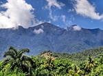
Summit Pico Turquino, Cuba
Pico Turquino is the highest point in Cuba. It is located in the southeast part of the island, in the Sierra Maestra mountain range in the municipality of Guamá, Santiago de Cuba Province. Guides are mandatory for this tough two- to three-day 17km trek through the steep forests of the Sierra Maestra. Revolutionary buffs should make a side trip to Fidel’s ... -
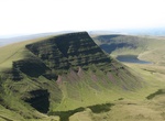
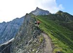
Hike Picws Du, Brecon Beacons National Park, Wales
Picws Du is the second highest peak of the Carmarthen Fans (or, in WelshBannau Sir Gaer) in the Carmarthenshire section of the Black Mountain in the west of the Brecon Beacons National Park in south Wales. The highest peak is Fan Foel immediately next along the ridge and it is a subsidiary summit of Fan Brycheiniog. Picws Du falls within Fforest Fawr Geopark and its p... -
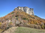
Hike to Pietra di Bismantova, Italy
The Pietra di Bismantova is a geological formation in the Reggiano Apennines, in thecomuneof Castelnovo ne' Monti, province of Reggio Emilia, central Italy, c. 45 km from Reggio Emilia. It has the shape of a narrow, quasi-cylindrical plateau (measuring 1 km x 240 m) whose steep walls emerge c. 300 m as an isolated spur from the nearby hills. The top has an elevat... -
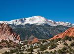
Visit Pikes Peak, Colorado
Pikes Peak (originally Pike's Peak) is a mountain in the Front Range of the Rocky Mountains within Pike National Forest, 10 miles (16 km) west of Colorado Springs, Colorado, in El Paso County in the United States of America. Originally called "El Capitán" by Spanish settlers, the mountain was renamed Pike's Peak after Zebulon Pike, Jr., an explorer who led an e... -
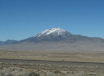
Explore Pilot Peak, Nevada
Pilot Peak (Shoshoni: Waahkai) is the highest mountain in the Pilot Range in extreme eastern Elko County, Nevada, United States. It is the most topographically prominent peak in Elko County and the fourth-most prominent peak in Nevada. The peak is on public land administered by the Bureau of Land Management and thus has no access restrictions. Pilot Peak was named in ... -
Summit Pilot Rock, Cascade-Siskiyou National Monument, Oregon
Pilot Rock is a prominent volcanic plug located in the western Cascade Range near the east end of the Siskiyou Mountains, just east of the Siskiyou Summit near Ashland, Oregon. Rising thousands of feet above the Shasta and Rogue valleys, it is a landmark distinguishable from over 40 miles (64 km) away. At 25.6 million years old, it is one of the oldest formations of t... -
Explore Pinnacles National Park, California
Pinnacles National Park is a protected mountainous area located east of central California's Salinas Valley, about 5 miles (8.0 km) east of Soledad and about 80 miles (130 km) southeast of San Francisco. The park's namesakes are the eroded leftovers of half of an extinct volcano. The national park is divided by the rock formations into East and West Divisions, connect... -
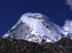
Summit Pisco Mountain, Peru
Pisco is a mountain in Peru, located in the Cordillera Blanca about 60 km north of Huaraz. It was first climbed on July 12, 1951 by C. Kogan, G. Kogan, R.Leininger and M. Lenoir. Previously, this mountain was popular for its easy climb. However, the primary climbing route has melted significantly. As a result, this mountain is no longer the easy climb it once was and ... -
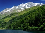
Summit Piz Beverin, Switzerland
Piz Beverin is a 2,997 meter mountain of the Lepontine Alps, overlooking Thusis in the canton of Graubünden. A trail leads to the summit. Piz Beverin is accessible via several simpler (mountain hiking trail) and some more difficult routes. The mountain is also a popular ski and snowboard tour destination. Through the western flank is probably the most beautiful c... -
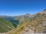
Explore Piz Corvatsch, Switzerland
Piz Corvatsch is a mountain in the Bernina Range of the Alps, overlooking Lake Sils and Lake Silvaplana in the Engadin region of the canton of Graubünden. With an elevation of 3,451 m (11,322 ft), it is the highest point on the range separating the main Inn valley from the Val Roseg. Aside from Piz Corvatsch, two other slightly lower summits make up the Corvatsch... -
Summit Piz Quattervals, Switzerland
Piz Quattervals (lit. "peak of the four valleys") is a mountain of the Livigno Alps, located in Graubünden, Switzerland. With a height of 3,165 metres above sea level, Piz Quattervals is the highest mountain of the chain north of Pass Chaschauna. Its mass lies between four valleys: Val Tantermozza, Valletta, Val Sassa and Val Müschauns, although its summit l... -
Hike Plynlimon, Wales
Plynlimon (anglicised fromPumlumonin Welsh, meaning "five peaks") is the highest point of the Cambrian Mountains in Wales, and the highest point in Mid Wales. It is a massif that dominates the countryside of northern Ceredigion. The highest point of the massif itself is Pen Pumlumon Fawr at 752 metres (2,467 ft). Its other important peaks are Pen Pumlumon Arwystli, Y ... -
Explore Pointe Helbronner, Italy
Pointe Helbronner (3,462 m (11,358 ft)) is a mountain in the Mont Blanc massif in the Graian Alps on the watershed between France and Italy. The peak, which used to be a mere geodetic reference point, was named after Paul Helbronner, a Frenchpolytechnicien, alpinist and geodesist who pioneered cartography of the French Alps. Pointe Helbronner is served on the Italian ...

Price: $174.00