Give us feedback!


 See all

Our philosophy is simple. We want to encourage you to dream. BIG! Then we help you plan your trip, get the most out of it while you're traveling and help you share your experience with friends.
Join Now It's FREE
Dream Packages
Duration: 3 days
Price: $707.56
Price: $707.56
Duration: 14 hours
Price: $949.99
Price: $949.99
Duration: 3 days
Price: $604.38
Price: $604.38
Duration: 9 hours
Price: $111.00
Price: $111.00
Related Categories
Dreams Still To Do
Checked-Off Dreams
Dreams Still To Do
Checked-Off Dreams
Advertisement
Explore Natural Wonders
-
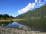
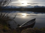
Explore Buttle Lake, BC, Canada
Buttle Lake is a lake on Vancouver Island in Strathcona Regional District, British Columbia, Canada. It is about 23 kilometres (14 mi) long and 1.5 kilometres (0.9 mi) wide, has an area of 28 square kilometres (11 sq mi), is up to 120 metres (394 ft) deep, and lies at an elevation of 221 metres (725 ft). The lake is located between Campbell River and Gold River in Str... -
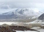
Explore Buttress Range, Katmai National Park, Alaska
The western side of the Valley of Ten Thousand Smokes is bordered by the Buttress Range. Along the Buttress Range, several small, inset alcoves provide water and inviting places to camp. Wildlife such as bears, ground squirrels, ptarmigan, and even caribou can be seen in this area. The crest of the Buttress Range is easily traversed along its length. -
Visit Büyükada, Prince Islands, Istanbul, Turkey
Büyükada is the largest of the nine so-called Princes' Islands in the Sea of Marmara, near Istanbul, with an area of about 2 square miles (5 square kilometres). It is officially a neighbourhood in the Adalar (Islands) district of Istanbul Province, Turkey. The island's name means "Big Island" in Turkish. Alternative Greek names are Πρίγκ&e... -
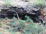
Visit Byaduk Caves, Victoria, Australia
The Byaduk Caves, lava tubes from the volcanic eruption of Mount Napier, are nearby. You can also see extensive views of the lava flow at Harmans Valley and the tumuli lava blisters off Old Crushers Road. -
Explore Byers Lake, Denali State Park, Alaska
Byers Lake is a small lake in Denali State Park, within the Matanuska-Susitna Borough, Alaska, United States, 28 miles (45 km) north of Talkeetna. The lake is named for a fisherman who was brought there many times by bush pilot Don Sheldon in the 1950s. It is accessible from the George Parks Highway and has a developed campground, several public-use cabins and a small... -
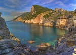
Visit Byron's Grotto (Grotta di Lord Byron), Porto Venere, Ligurian Coast, Italy
Byron's Grotto, so named because the poet Lord Byron used to meditate there. -
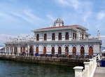
See Caballo Island (Fort Frank & Fort Hughes), Manila Bay, Philippines
Caballo Island (which means "Horse Island" in Spanish) is a bluff, rocky island located at the entrance to Manila Bay in the Philippines. It is about 1.2 km (0.75 mi) long with the highest elevation at 381 feet high. Caballo, along with the larger Corregidor (2 km to the north), divides the entrance to the bay into two broad and deep channels, known as the North and S... -
See Cabeça da Velha, Portugal
Cabeça da Velha, or The Old Head, is a rock formation in Sortelha that resembles a head. It was created by atmospheric erosion which caused the specific shape of the rock. -
Hike Cabeço do Canto, Faial Island, Azores, Portugal
Cabeço do Canto is a volcanic cone on island of Faial, archipelago of the Azores. There is a lava tube and bunker in the area. -
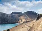
See Cabeco do Canto Dyke, Capelinhos, Faial Island, Azores, Portugal
A spectacular feeder dike of Cabeco do Canto volcano on Capelinhos coastline. It's now exposed by erosion. -
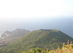
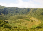
Explore Cabeço Gordo, Faial Island, Azores
Cabeço Gordo (Portuguese for "fat mountain") is the highest mountain, massive stratovolcano and the largest geomorphological structure that forms the island of Faial. The mountain/volcano is 1,043 meters above sea level, consisting of a two kilometer wide caldera, that is 400 m in depth below the crater rim. From Cabeço Gordo, on a clear day, the islands... -
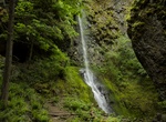
Hike to Cabin Creek Falls, Starvation Creek State Park, Oregon
Cabin Creek Falls is located along Starvation Ridge Trail in Starvation Creek State Park, Oregon. -
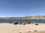
Kiteboard or Windsurf Cabinsite Point (Lake Mohave), Arizona
The National Park Service has set aside the area near Cabinsite Point on Lake Mohave as a Kiteboarding Use Area. Use caution with gusty winds. How to Get There: North of Katherine Landing A permit is required to kiteboard on the lake. TIPS: Recommended for advanced kiteboarders Both Lake Mead and Lake Mohave are known for extremely gusty winds and can ... -
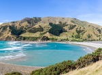
Visit Cable Bay, New Zealand
Rotokura / Cable Bayis a 600 metres (2,000 ft) wide, northwest-facing bay in the Tasman Bay. It lies just north of the Horoirangi Marine Reserve, between the tidal island Pepin Island and the mainland. It provides a natural boulder barrier from the sea for the Wakapuaka estuary. The sheltered beach at Cable Bay has sandy patches but is mostly a shingle beach. The... -
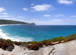
Visit Cable Beach, Torndirrup National Park, Western Australia
Located right next to The Gap and Natural Bridge, Cable Beach is known for its rough and treacherous waves and coastline.

Price: $249.99