Give us feedback!


 See all

Our philosophy is simple. We want to encourage you to dream. BIG! Then we help you plan your trip, get the most out of it while you're traveling and help you share your experience with friends.
Join Now It's FREE
Dream Packages
Duration: 7 days
Price: $1995.00
Price: $1995.00
Duration: 8 hours
Price: $227.92
Price: $227.92
Duration: 2 days
Price: $240.61
Price: $240.61
Duration: 3 hours
Price: $103.11
Price: $103.11
Related Categories
Dreams Still To Do
Checked-Off Dreams
Dreams Still To Do
Checked-Off Dreams
Advertisement
Explore Natural Wonders
-
Explore Akiyoshidai Quasi-National Park, Japan
Akiyoshidai Kokutei Kōen is a Quasi-National Park in Yamaguchi Prefecture, Japan. It was founded on 1 November 1955 and has an area of 45.02 km². It includes part of the Akiyoshi plateau (秋吉台, Akiyoshidai), a 130 square kilometre area of karst topography, as well as over 400 limestone caves. The area is rated a protected landscape (category V) according to t... -
Explore Akiyoshidō Cave, Japan
Towards the southern end of Akiyoshidai Quasi-National Park is the Akiyoshidō cave, named by Emperor Hirohito on May 30, 1926, when he was still crown prince. This spacious cave is up to 100 meters wide and has 8.79 kilometers of passages, making it one of the longest in Japan after Akkadō cave, and one of the longest in Asia. At the present time an about one-kilome... -
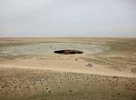
Visit Akjagaýa Depression, Turkmenistan
Akjagaýa is a depression in the northwest Karakum Desert. It is located to the south of Sarykamyska Valley. It is about 50 km long and 6 km wide. The lowest point is 81 m below sea level, making it the lowest point in Turkmenistan. -
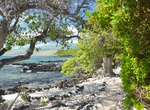
Visit Akti Miaouli Beach, Rhodes, Greece
Akti Miaouli beach is a sandy pebble beach on the Aegean side of Rhodes, located in short walking distance to Rhodes town. -
Visit Akun Island
Akun Island (Aleut:Akungan) is one of the Fox Islands subgroup of the Aleutian Islands in the Aleutians East Borough of southwestern Alaska. The island lies east of Akutan Island and southwest of Unimak Island, across the Unimak Pass strait. The Krenitzin Islands lie to the south and southeast, across the Avatanak Strait. Akun Island has a land area of 64.39 sq mi (16... -
Visit Akureyri Botanical Garden, Akureyri, Iceland
The Akureyri Botanical Garden is located on the west side of the inland end of the fjord Eyjafjörður at about 45 metres elevation. It is located in the southern part of the city of Akureyri in Northern Iceland, 50 kilometres south of the Arctic Circle. It is one of the northernmost botanical gardens in the world. In 1910, women from Akureyri founded the Park ... -
See Akutan Hot Springs, Akutan Island, Alaska
A hot spring discharges 77°C (~171°F) water into Hot Springs Creek, Akutan Island, Alaska. Numerous industry-led geophysical studies and test drilling in the past few years have proven the existence of a geothermal resource. USGS field studies completed in 2012 suggest that the available geothermal resource may be even larger than previously recognized. The c... -
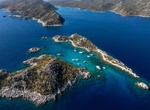
Visit Akvaryum Koyu at Kara Island, Kaş, Turkey
Akvaryum Koyu is a great anchorage just west of Kekova Island, Turkey. -
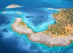
Visit Akvaryum Koyu (Ölüdeniz), Fethiye, Muğla, Türkiye
Akvaryum Koyu is a beautful cove near Ölüdeniz, Fethiye, Muğla, Türkiye. There are several coves named "Akvaryum Koyu" in the area. -
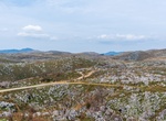
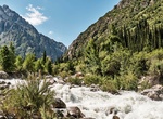
Explore Ala Archa National Park, Kyrgyzstan
The Ala Archa National Park is an alpine national park in the Tian Shan mountains of Kyrgyzstan, established in 1976 and located approximately 40 km south of the capital city of Bishkek. The park, which includes the gorge of the Ala-Archa River and the mountains surrounding it, is a popular destination point for weekend picnicers, hikers, horse trekkers, skiers as wel... -
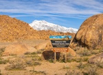
Explore Alabama Hills, California
Alabama Hills is known for its rock formations that have atracted movie makers, photographers and tourist from all over the world. The hills are located in Inyo County, California. Explore the hills by cara, bike or hiking. Since the early 1920's, move stars such as Gen Autry, Hopalong Cassidy and the Lone Ranger have been shooting it out with outlaws in the Alabama H... -
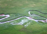
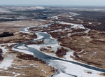
Explore Alagnak Wild River, Alaska
The Alagnak River is a 79-mile (127-kilometre) long river in Alaska. It has a catchment area of approximately 1400 square mi (3600 km²). It is located in central Lake and Peninsula Borough. In Yupik, the word "Alagnak" means "to err." Every year, the river changes its course and branches anew, for which reason it is sometimes called the "Branch River." The Alagna... -
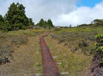
Hike Ala Kahakai National Historic Trail, Big Island, Hawaii
Ala Kahakai National Historic Trail is a 175-mile (282 km) long trail located on the island of Hawaiʻi. It is not yet a continuous "trail", but can be accessed at several broken segments along the coastline of the Big Island. The trail was established to access the traditional Ancient Hawaiian culture along with the natural geology of the island. The trail was establ... -
Hike Alakaʻi Swamp Trail, Kauai, Hawaii
The Alakaʻi Wilderness Preserve, popularly known as Alakaʻi Swamp, is a montane wet forest on the Hawaiian island of Kauaʻi. Although the preserve is home to alpine bogs, it is not a true swamp. It is located on a plateau near Mount Waiʻaleʻale, one of the wettest spots on Earth. The 3.5-mile (5.6 km) Alakaʻi Swamp trail is often shrouded in mist. This trail can be re... -
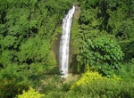
See Alalum Falls, Mindanao Island, Philippines
Alalum Falls is located along the Sayre Highway and less than a kilometer distance from the Municipal Hall. Its imposing grandeur can easily be seen by travelers on motor vehicles. It is approximately 148 feet (45 m) high. However, due to ongoing public constructions, it may be difficult to catch a glimpse of the attraction. But the falls will be open to public again ...


Price: $618.62