Give us feedback!


 See all

Our philosophy is simple. We want to encourage you to dream. BIG! Then we help you plan your trip, get the most out of it while you're traveling and help you share your experience with friends.
Join Now It's FREE
Dream Packages
Duration: 2 days
Price: $337.00
Price: $337.00
Duration: 2 days
Price: $359.00
Price: $359.00
Duration: 3 days
Price: $615.59
Price: $615.59
Duration: 3 days
Price: $489.00
Price: $489.00
Related Categories
Dreams Still To Do
Checked-Off Dreams
Dreams Still To Do
Checked-Off Dreams
Advertisement
Explore Natural Wonders
-
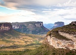
Explore Chapada Diamantina National Park, Brazil
The Chapada Diamantina National Park (Parque Nacional da Chapada Diamantina) is a 1,520 km² national park in the Chapada Diamantina region of the State of Bahia, Northeast Brazil. The park is located about 400 kilometres inland from Salvador, the capital city of Bahia. Chapada is a Brazilian word that means a region of steep cliffs, usually at the edge of a plate... -
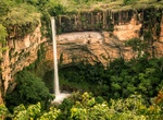
Explore Chapada dos Guimarães National Park, Mato Grosso, Brazil
Chapada dos Guimarães National Park is a national park in the state of Mato Grosso, Brazil. It is a region of rugged terrain with dramatic cliffs and waterfalls, and contains the geographical centre of the continent. The climate is tropical, with temperatures ranging from 12 to 25 °C (54 to 77 °F) and annual rainfall of 1,800 to 2,000 millimetres (71 to... -
Explore Chapada dos Veadeiros National Park, Brazil (UNESCO site)
Brazil's Chapada dos Veadeiros National Park is located in the Chapada dos Veadeiros, an ancient plateau with an estimated age of 1.8 billion years. Based in the Brazilian state of Goias, the Park was created on January 11, 1961 by President Juscelino Kubitscheck, and listed as a World Heritage Site by Unesco in 2001. Its rock formations are one of the oldest on the p... -
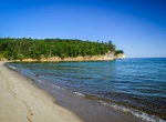
Camp at Chapel Beach Campground, Pictured Rocks National Lakeshore, Michigan
Chapel Beach Campground sits on the sand bluff above Chapel Beach and Lake Superior. As you wind your way along the campground trail, the first three sites are hidden in the trees and offer a bit of privacy. The fourth site provides a view of Lake Superior and the cliff line. The fifth site is hidden among the ferns and pine trees. Shared pit toilet. Water source is C... -
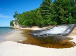
See Chapel Beach Falls, Pictured Rocks National Lakeshore, Michigan
Chapel Beach Falls is located at the eastern end of Chapel Beach in Pictured Rocks National Lakeshore. -
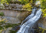
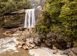
Hike to Chapel Falls, Pictured Rocks National Lakeshore, Michigan
Chapel Falls is located about 15 miles east of Munising off Alger County Road H-58, then about 5 miles north to the end of Chapel Road. After a brisk 1.5 mile walk, hikers can view the 60-foot high Chapel Falls as it cascades toward Chapel Lake.The trail is on an old roadbed with several small hills. Two viewing platforms along the way provide views of the scenic Chap... -
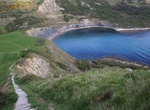
Explore Chapman's Pool, Isle of Purbeck, Dorset, England
Chapman's Pool is a small cove to the west of Worth Matravers on the Isle of Purbeck, in Dorset, England. The rocks that form the cove are the upper parts of the Kimmeridge Clay, and are rich in fossils, especially bivalves and ammonites. Most of these fossils are flattened, but three-dimensional examples are preserved in the "Rotunda Nodules", including the age-marke... -
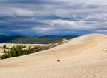
Explore Chara Sands "Desert in Siberia", Russia
Chara Sands is a 37 square kilometers (14 sq mi) area of sand dunes 40 kilometers from the Kodar Glaciers in Kalar district of Trans-Baikal region of Russia. Chara Sands is like a real desert, but with features you won’t see anywhere else. Some of the dunes are as high as 15 – 30 meters. The town of Novaya Chara is the starting point for trekking tours in... -
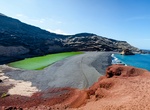
See Charco de los Clicos (Lago Verde), Lanzarote, Canary Islands
Charco de los Clicos (Lago Verde) is loacted on the western side of Lanzarote Island in the Canary Islands. This green lagoon is filled with micro-orgamisms and minerals. This pond owes its charasteristic color to a specific kind of seaweed. -
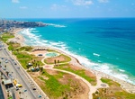
Visit Charles Clore Beach & Park, Tel Aviv, Israel
Charles Clore Park is a beachfront public park in southwestern Tel Aviv, Israel. The park covers 29.6-acre of public land and runs along the Mediterranean Sea. It is named for Charles Clore, a British financier, property magnate. -
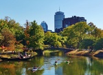
Visit Charles River, Boston, Massachusetts
The Charles River (sometimes called the River Charles or simply the Charles) is an 80-mile (129 km) long river in eastern Massachusetts. From its source in Hopkinton the river's mouth is northeast of its headwaters, though it follows a highly meandering route, doubling back on itself several times and traveling through 23 cities and towns before reaching the Atlantic ... -
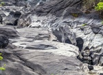
See Charlie Brown Outcrop, Charles Brown Hwy, Shoshone, California
Known informally as the Charlie Brown Outcrop, this distinctive road-cut is a popular stop for geologists heading to Death Valley. -
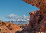
Hike to Charlie's Spring, Valley of Fire State Park, Nevada
Charlie's Spring Trail goes down a wash for 1.2 miles to North Fork Valley of Fire Wash. The trail is not marked - just stay in the wash and travel down like water. CLOSURE NOTICE: Due to the heat from Mid May to the end pf Sept, rangers close all trails longer than 1 mile - which might include this one. -
Hike or Mountain Bike Charming Creek Walkway to Mangatini Falls, New Zealand
Hike to Mangatini Falls along Charming Creek Walkway along the Ngakawau river near Ngakawau, New Zealand. Scenery and history combine as you walk on an old railway formation. The Charming Creek Walkway is 19 km out and back and takes about 6 hours to hike. Mountain bike is intermediate grade 3. There are two points of access to the walkway. The southern end is clear... -
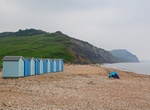
Visit Charmouth Beach, England
Charmouth is a coastal village which overlooks Lyme Bay and is part of the Jurassic Coast. It lies among steep hills and is sited on a sloping site to the west of the River Char, close to its mouth at the English Channel. Stonebarrow Hill is to the east, Black Venn to the west, and Golden Cap, the highest cliff on the south coast of England at 191 metres (627 ft), is ...

Price: $109.00