Give us feedback!


 See all

Our philosophy is simple. We want to encourage you to dream. BIG! Then we help you plan your trip, get the most out of it while you're traveling and help you share your experience with friends.
Join Now It's FREE
Dream Packages
Duration: 2 days
Price: $346.48
Price: $346.48
Duration: 12 hours
Price: $103.26
Price: $103.26
Duration: 5 hours
Price: $137.22
Price: $137.22
Duration: 12 hours
Price: $120.00
Price: $120.00
Related Categories
Dreams Still To Do
Checked-Off Dreams
Dreams Still To Do
Checked-Off Dreams
Advertisement
Explore Natural Wonders
-
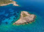
Visit Heart Island (Sapientza Island), Peloponnese, Greece
The "Heart Island" in the Peloponnese, Greece, is actually named Sapientza Islan and is located off the coast of Methoni. Sapientza's unique shape and the presence of numerous shipwrecks in the surrounding waters make it a popular destination. The island's name, "Sapientza," translates to "wisdom" in Italian, reflecting the historical warnings given to sailors navigat... -
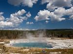
Hike to Heart Lake Geyser Basin, Yellowstone National Park, Wyoming
Heart Lake Geyser Basin is a small isolated basin that is mostly pools and vents of many different colors and forms, but also several geysers. The main features are Rustic Geyser and Columbia Pool, located at the far side of the basin beneath the reddish slopes of Mount Sheridan, and 7.5 miles from the nearest highway (the Grand Loop Road between the South Entrance an... -
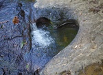
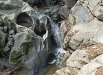
Hike to Heart of Farino, New Caledonia
The famous Heart of Farino. A heart shaped gap in the rock of a river bed. Great Fern Park, New Caledonia. -
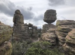
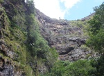
Hike Heart of Rocks Loop to Visitor Center, Chiricahua National Monument, Arizona
Heart of Rocks Loop Trail is a 7.3 miles (1.8 km) trail that combines the Ed Riggs, Mushroom Rock, Big Balanced Rock, Heart of Rocks Loop, Sarah Deming and Lower Rhyolite Canyon Trails. The trail is accessed from Massai Point or Echo Canyon Parking Lot. Make sure you have transportation back to your vehicle. Watch for changes in vegetation from the upper canyon area... -
Hike to Heart Rock, Joshua Tree National Park
Heart Rock is located near White Tank Campground. Its about a half mile northeast of Arch Rock. It's hard to see until you get close. Day hikers cannot park at White Tank campground to get to Arch Rock or Heart Rock. Parking is across the street at 2 Tanks and start hike from there. -
See Heart Rock at Preveli Beach, Piso Moni Preveli, Crete, Greece
Heart rock formation off a beautiful beach, river and palm trees. -
Hike Heart Rock Trail (Seely Creek Falls), Silverwood Lake State Recreation Area, California
Heart Rock Waterfall, which is also known as Seely Creek Falls, is located in Crestline, California. The waterfall has an almost perfect cut out of a heart right alongside it. -
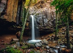
Hike to Heart Shaped Waterfall, Jamestown, Saint Helena Island
The hike to Heart Shaped Waterfall is through a rough muddy path - especially when it rains. But worth the effort. Water does not alwayys flow. The 90m waterfall runs mostly in the winter and early spring, fed by the winter rains. It's 1.6 km out and back from Barnes Rd. -
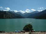
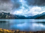
See Heaven Lake of Tian Shan (Tianchi), Xinjiang, China
Tianchi is an alpine lake in Xinjiang, Northwest China. The name literally means "Heaven Lake" or "Heavenly Lake" and can refer to several lakes in mainland China and Taiwan. This Tianchi lies on the north side of the Bogda Shan range of the Tianshan Mountains, about 30 kilometres (19 mi) south of Fukang City and 45 kilometres (28 mi) east (straight-line distance) of ... -
Visit Heavenly Lake of Tianshan, China
Tianchi is an alpine lake in Xinjiang, Northwest China. The name (天池) literally means Heavenly Lake and can refer to several lakes in mainland China and Taiwan. This Tianchi lies on the north side of the Bogda Shan ("Mountain of God",Bogdais a Mongolian word meaning "God") range of the Tian Shan ("Mountain of Heaven"), about 30 kilometres (19 mi) south of Fukang and 4... -
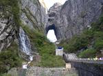
Climb Heaven's Gate Stairs, Tianmen Mountain, China
Tianmen Shan (Heaven's Gate Mountain) is a cave natural arch eroded through a karst syncline. It is located about 8 km south of the city of Zhangjiajie (formerly Dayong) in northern Hunan Province, China. It is accessed from Zhangjiajie by what may be the world's longest skytram (7.5 km) that leads to a bus ride on a very winding road, followed by a set of stairs with... -
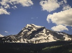
See Heavens Peak, Glacier National Park, Montana
Heavens Peak (8,987 feet (2,739 m)) is located in the Livingston Range, Glacier National Park in the U.S. state of Montana. Heavens Peak is a little more than 1 mile (1.6 km) north of McPartland Mountain and can be viewed from Going-to-the-Sun Road. -
Visit Hebert Arboretum, Massachusetts
The Hebert Arboretum is a new arboretum located at Springside Park in Pittsfield, Massachusetts, United States. The Arboretum displays a diverse collection of trees and other plants in formal landscapes in a natural setting. The Arboretum was officially established in 1999 to carry out a dream of former Parks Superintendent Vincent Hebert. A master plan was developed ... -
See Hedge Creek Falls, Dunsmuir, California
Hedge Creek Falls is a waterfall on Hedge Creek, in the Shasta Cascade area in Dunsmuir, California. There is a small cave located behind the waterfall, allowing visitors to walk behind the cascading water. Shortly after the waterfall, hedge creek flows into the Sacramento River south of Mossbrae Falls. There is a viewing platform over the river, with a view of Mount ... -
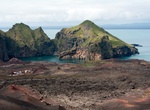
Explore Heimaey Island, Iceland
Heimaey is an Icelandic island. At 13.4 square kilometres (5.2 sq mi), it is the largest island in the Vestmannaeyjar archipelago, and the largest and most populated island off the Icelandic coast. Heimaey is 4 nautical miles (7.4 km; 4.6 mi) off the south coast of Iceland. It is the only populated island of the Vestmannaeyjar islands, with a population of 4,500. The ...


Price: $707.56