Give us feedback!


 See all

Our philosophy is simple. We want to encourage you to dream. BIG! Then we help you plan your trip, get the most out of it while you're traveling and help you share your experience with friends.
Join Now It's FREE
Dream Packages
Duration: 12 hours 30 minutes
Price: $164.45
Price: $164.45
Duration: 2 days
Price: $337.00
Price: $337.00
Duration: 2 days
Price: $346.48
Price: $346.48
Duration: 2 days
Price: $340.00
Price: $340.00
Related Categories
Dreams Still To Do
Checked-Off Dreams
Dreams Still To Do
Checked-Off Dreams
Advertisement
Explore Natural Wonders
-
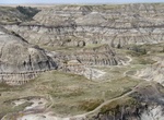
Explore Horseshoe Canyon, Alberta, Canada
Horseshoe Canyon is a region of badlands surrounded by prairie in the province of Alberta, Canada. There are many many hiking trails in the canyon. One of the best times to visit is at sunrise when the view can be spectacular. The canyon gets its name from its horseshoe shape, defined by two coulees the flow into the Kneehill Creek, a tributary of the Red Deer River. ... -
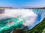
See Horseshoe Falls (Canadian Falls), Niagara Falls, Canada & USA
Horseshoe Falls, also known as Canadian Falls, is the largest of the three waterfalls that collectively form Niagara Falls on the Niagara River along the Canada–United States border. Approximately 90% of the Niagara River, after diversions for hydropower generation, flows over Horseshoe Falls. The remaining 10% flows over American Falls and Bridal Veil Falls. It... -
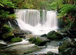
See Horseshoe Falls (Mount Field National Park), Tasmania, Australia
Horseshoe Falls are located 100 metres (330 ft) upstream of Russell Falls at Mount Field National Park, in Tasmania, Australia. The falls are a popular tourist attraction. Horseshoe Falls are composed of horizontal marine Permian siltstone benches, as are Russell Falls. Horseshoe Falls is a 30 minute walk from the visitor center. -
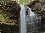
See Horseshoe Falls (Munising), Michigan
Horseshoe Falls on Stutts Creek near Munising. From M-28 near Munising's southern limits, turn east onto Prospect St. Go 2 blocks to Bell Avenue and turn left (north). Go 1 block to Horseshoe Falls parking area on the right. The Anna River is a 7.1-mile-long (11.4 km) river on the Upper Peninsula of the U.S. state of Michigan. The river rises in the Anna Marsh in east... -
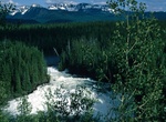
Hike to Horseshoe Falls (Wells Gray Provincial Park), British Columbia, Canada
Horseshoe Falls is one of seven waterfalls on the Murtle River west of Murtle Lake in Wells Gray Provincial Park, east-central British Columbia, Canada. Horseshoe Falls has two steps, 100 m (328 ft) apart; the upper drop is 6 m (20 ft) high and the lower and much wider drop is 10 m (33 ft) high. Horseshoe Falls can be reached by a 14 km (8.7 mi) hiking trail from Pyra... -
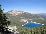
Explore Horseshoe Lake, Mammoth Lakes, California
Horseshoe Lake is located just south of Mammoth Lakes, California. Leave Hwy 395 at Mammoth Lakes, Hwy 203 and follow Lake Mary Road. Follow the signs to Horseshoe Lake. -
Visit Horseshoe Lake, Washington State
Horseshoe Lake is a lake situated in the east side of the Midway High Lakes Area below Mount Adams' northwest flank. The lake is popular for camping, quiet boating (electric motors or canoeing), and hiking and biking on a trail halfway around the lake. Other activities include scenic viewing and fishing. The lake offers an eleven-site campground, administered by the G... -
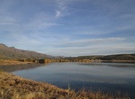
Explore Horseshoe Lake, Arizona
Horseshoe Lake is a reservoir that was formed by the Horseshoe Dam on the Verde River in the U.S. state of Arizona. The lake and dam are located inside the Tonto National Forest is located upstream and north of Bartlett Lake. The dam is managed by the Salt River Project. -
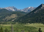
Explore Horseshoe Park, Larimer County, Colorado
Horseshoe Park is a flat at 8,524 feet (2,598 m) in elevation in Larimer County, Colorado. It is within the Rocky Mountain National Park, which lies between Estes Park to the east and Grand Lake, Colorado on the west. Horseshoe Park is home to bighorn sheep, elk and other wildlife, and it is a wetland sanctuary for wide variety of birds. Recreational activities includ... -
See Horsetail Fall at Sunset, Yosemite National Park
Horsetail Fall, located in Yosemite National Park in California, is a seasonal waterfall that flows in the winter and early spring. The fall occurs on the east side of El Capitan. There are a few days every February where this fall is lit up by the setting sun and reflects a bright orange. This waterfall descends in two streams side by side, the eastern one being... -
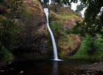
See Horsetail Falls, Oregon
Horsetail Falls is a waterfall along the Columbia River Gorge in Oregon, United States. There are actually two waterfalls along the creek. The upper falls, called Upper Horsetail Falls or Ponytail Falls, can be accessed from a footpath. The waterfall is easily accessed, in contrast to its near neighbor Oneonta Falls, as it is right next to the Historic Columbia River... -
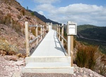
Hike to Horsetail Falls, Tasmania, Australia
Horsetail Falls is a seasonal waterfall near Queenstown, Tasmania. The falls cascades over 50 metres down a steep cliff face, and can be seen from the road. A boardwalk giving closer access was opened in 2017. -
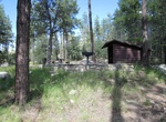
Camp at Horsethief Basin Recreation Area, Prescott National Forest, Arizona
Horsethief Basin Recreation Area offers a variety of recreational opportunities including: hiking, mountain biking, horseback riding, camping, fishing, and OHV riding. Castle Creek Wilderness is located nearby, and Horsethief Cabin and Turney Gulch Group Campground are available by reservation. Day use sites and trails are open year-round; overnight accomodations are ... -
Explore Horsethief Canyon, Alberta
Horsethief Canyon is found 16 kilometres (9.9 mi) northwest of the town of Drumheller, in Starland County in the province of Alberta, Canada. It is on the east bank of the Red Deer River, along Highway 838 (known locally as North Dinosaur Trail). Both Horsethief Canyon and Horseshoe Canyon are distinctive features of the surrounding badlands of central Alberta. Althou... -
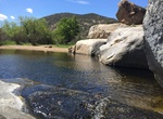
Hike Horsethief Canyon, Alpine, California
Horsethief Canyon is about 3.3 miles long and located near Alpine, California. The trail is great for hiking and normally takes 1-3 hours. This is a great, short hike down to a small swimming hole surrounded by rocks. Connects to the Pine Creek Wilderness, the Secret Canyon Trail, and the Espinoza Trail.


Price: $334.68