Give us feedback!


 See all

Our philosophy is simple. We want to encourage you to dream. BIG! Then we help you plan your trip, get the most out of it while you're traveling and help you share your experience with friends.
Join Now It's FREE
Dream Packages
Duration: 3 days
Price: $618.62
Price: $618.62
Duration: 3 hours 30 minutes
Price: $179.75
Price: $179.75
Duration: 14 to 15 hours
Price: $170.10
Price: $170.10
Duration: 13 hours
Price: $133.43
Price: $133.43
Related Categories
Dreams Still To Do
Checked-Off Dreams
Dreams Still To Do
Checked-Off Dreams
Advertisement
Explore Natural Wonders
-
Explore Kaihoka Lakes Scenic Reserve, New Zealand
Take an easy walk through coastal forest to two beautiful lakes. -
Visit Kai Islands, Indonesia
The Kai Islands (Kei Islands) of Indonesia are in the south-eastern part of the Maluku Islands, in Maluku Province. Inhabitants called the islands Nuhu Evav (Evav Islands) or Tanat Evav (Evav Land), but known as Kei for people from neighbourhood islands. "Kai" is actually a Dutch colonial era spelling, still persisting in books based on old resources. The islands are ... -
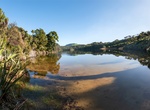
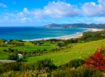
Explore Kai Iwi Lakes & Sand Dunes, Northland, New Zealand
Located north of Dargaville, the Kai Iwi Lakes are basin-type dune lakes created during the Pleistocene Epoch, which began more than 1.8 million years ago. They were formed by the accumulation of rainwater in depressions of sand. Underlying ironstone prevents the water from leaking away. Each of the three lakes is fringed with pure white sand and there are shallow are... -
Visit Kailua, Oahu, Hawaii
Kailua is in Oʻahu, Hawaii on the windward coast at Kailua Bay. In the Hawaiian language Kailua means "two seas," or "two currents," a contraction of the words kai (meaning sea or sea water) and ʻelua (meaning two); it is so named because of the two lagoons in the district or the two currents which run through Kailua Bay. Kailua is primarily a residential community, ... -
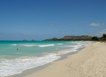
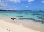
Relax on Kailua Beach, Oahu, Hawaii
Kailua Beach is often cited as Hawaii's best beach. It was ranked as the finest American beach in 1998 by coastal expert Dr. Stephen Leatherman, and then "retired" from subsequent consideration. The beach is crescent-shaped, about 2.5 miles (4.0 km) long and ranging between 50 and 150 feet (15 and 46 m) wide. The ocean bottom fronting the beach slopes gently to o... -
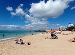
Visit Kaimana Beach, Honolulu, Hawaii
Family-friendly ocean retreat offering shallow waters, a snorkeling reef & surfing spots. -
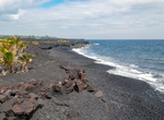
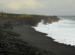
Visit Kaimū Beach, Big Island, Hawaii
Kaimū Beach is the world's newest black sand beach. It's located at the south end of State Route 130, a 1/4 mile walk from the end of the road. There is a decent little cafe there too; Kalapana Cafe. Kaimū was a small town in the Puna District on Island of Hawaiʻi that was completely destroyed by an eruptive flow of lava from the Kūpaʻianahā vent of the Kīlauea volca... -
Visit Kaimu Beach Park, Big Island, Hawaii
Kaimu Beach Park is a black sand beach at the end of the Kalapana-Kapoho Road (Red Road). Not a good beach for swimming or snorkeling. -
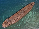
Visit Kaiolohia (Shipwreck Beach), Lanai, Hawaii
Shipwreck Beach (Kaiolohia) on the north shore of the island is a 6-mile stretch of coastline on Lanai where roughly a dozen vessels have grounded. Two of the most easy to spot wrecks are the YOGN-42, a ferro-cement Navy fuel barge, and the YO-21, a massive Navy yard oiler that had been docked at Pearl Harbor during the 1941 attack. USS YOG-42 was a gasoline barge b... -
Visit Kaiona Beach Park, Oahu, Hawaii
Kaiona Beach Park has soft white sand and bright turquoise ocean located at the south end of Waimanalo Bay on Oahu's windward (east) coast. -
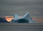
Explore Kaiser Franz Joseph Fjord, Greenland
Kaiser Franz Joseph Fjord is a major fjord system in the NE Greenland National Park area, East Greenland. The Kaiser Franz Joseph Fjord has its mouth in the Foster Bay of the Greenland Sea, between Cape Mackenzie at the eastern end of Geographical Society Island and Cape Franklin, the southern end of the mainland's Gauss Peninsula; Bontekoe Island lies in the bay off ... -
Camp at Kaiteriteri Beach, New Zealand
Kaiteriteri is a town and seaside resort in the Tasman Region of the South Island of New Zealand. The town is best known for its scenic beach and was on CNN Travel #68 World's 100 best beaches list in 2013. Kaiteriteri Beach campgrounds are rated as a Four Star Plus holiday park by Qualmark, the Kaiteriteri Reserve Camp has a rich history and is extremely popular. Th... -
Visit Kaitoke Beach, Great Barrier Island, New Zealand
Kaitoke Beach is a long sandy beach and settlement on the east coast of Great Barrier Island in the Hauraki Gulf of the Auckland Region of New Zealand. At the northern end is the Kaitoke Creek, which drains the Kaitoke Swamp, and a headland, beyond which is Palmers Beach. At the southern end is the Sugar Loaf headland and beyond that Medlands Beach. Kaitoke Beach has ... -
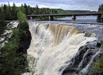
Visit Kakabeka Falls, Ontario, Canada
Kakabeka Falls is a waterfall on the Kaministiquia River, located beside the village of Kakabeka Falls in the municipality of Oliver Paipoonge, Ontario, 30 km (19 mi) west of the city of Thunder Bay. The falls have a drop of 40 m (130 ft), cascading into a gorge carved out of the Precambrian Shield by meltwater following the last glacial maximum. Because of its size a... -
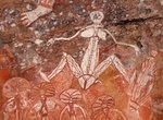
See Kakadu Aboriginal Rock Art Sites, Australia (UNESCO site)
The art sites of Ubirr, Burrunguy (Nourlangie Rock) and Nanguluwur are internationally recognized as outstanding examples of Aboriginal rock art. These sites are found in rocky outcrops that have afforded shelter to Aboriginal inhabitants for thousands of years. Ubirr is a group of rock outcrops in the northest of the Park, on the edge of the Nadab floodplain. There s...
Price: $1457.59