Give us feedback!


 See all

Our philosophy is simple. We want to encourage you to dream. BIG! Then we help you plan your trip, get the most out of it while you're traveling and help you share your experience with friends.
Join Now It's FREE
Dream Packages
Duration: 3 days
Price: $604.38
Price: $604.38
Duration: 6 hours
Price: $334.68
Price: $334.68
Duration: 10 hours
Price: $133.00
Price: $133.00
Duration: 2 days
Price: $469.00
Price: $469.00
Related Categories
Dreams Still To Do
Checked-Off Dreams
Dreams Still To Do
Checked-Off Dreams
Advertisement
Explore Natural Wonders
-
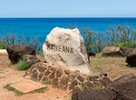
See Lower Makua Cave (Kaneana Cave), Oahu, Hawaii
Makua Cave is located on Oahu's Leeward Coast 3 miles north of the Makaha town, about a mile after Keeau Beach Park. You may park your car across from the cave. The drive from Honolulu will take about an hour. -
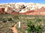
Hike Lower Muley Twist Canyon, Capitol Reef National Park
Lower Muley Twist Canyon in Capitol Reef National Park offers many options for side trips and off-trail exploring. The 6 mile (9.7 km) one way hike is in a deep, narrow, twisting canyon with large alcoves. Leave a vehicle at each end. From 1881 to 1884, the canyon served as a wagon route for Mormon pioneers traveling south toward San Juan County. The canyon was though... -
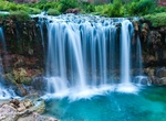
See Lower Navajo Falls, Havasupai Indian Reservation, Arizona
Lower Navajo Falls is located in Havasupai Indian Reservation upstream from Havasu Falls. It was created when the creek rerouted during the 2008 flood, drying up Old Navajo Falls. -
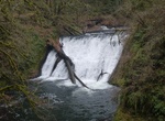
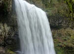
Hike to Lower North Falls, Silver Falls State Park, Oregon
Lower North Falls, is a 30 feet (9.1 m) tall waterfall located in the Silver Falls State Park at the east end of the city of Salem, in Marion County, in the U.S. state of Oregon. It is located in a privileged area on the west foothills where Mount Hood National Forest meets with the Middle Santiam Wilderness. Several prominent waterfalls are located in the Park along ... -
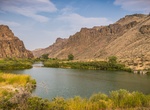
Explore Lower Owyhee Canyon, Oregon
A majestic and overlooked area on the primary road to Lake Owyhee State Park, the Lower Owyhee Canyon area includes the Owyhee River Below the Dam Area of Critical Environmental Concern -- 11,239 acres of public land in and around the Owyhee River canyon just north of the Owyhee Dam. This area features the controlled-flowing Owyhee River with its narrow canyon bottom... -
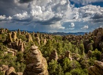
Hike Lower Rhyolite Canyon & Sarah Deming Canyon, Chiricahua National Monument, Arizona
A good way to view the rocks without driving up the road, this mostly-level trail takes you to Rhyolite Canyon, a canyon lined with rock pinnacles. Walk 1.5 miles / 2.4 km until you reach the junction between Upper Rhyolite Canyon and Sarah Deming trails. Return the same way. -
Explore Lower Saranac Lake, Adirondacks, New York
Lower Saranac Lake is one of three connected lakes, part of the Saranac River, near the village of Saranac Lake in the Adirondacks in northern New York. With Middle Saranac Lake and Upper Saranac Lake, a 17-mile (27 km) paddle with only one portage is possible. The Saranac Lake Islands Public Campground provides 87 campsites on inlands in Lower and Middle Saranac Lake... -
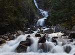
Hike to Lower South Falls, South Falls, Silver Falls State Park, Oregon
Lower South Falls, is a 93 feet (28 m) waterfall located in the Silver Falls State Park at the east end of the city of Salem, in Marion County, in the U.S. state of Oregon. It is located in a privileged area on the west foothills where Mount Hood National Forest meets with the Middle Santiam Wilderness. Several prominent waterfalls are located in the Park along Trail ... -
Hike Lower Spring Canyon, Capitol Reef National Park, Utah
The Lower Spring Canyon in Capitol Reef National Park is a back country route through the park. The canyon is about 7 miles long to where it meets up with Chimney Rock Canyon Trail. Hikers typically start at Chimney Rock Canyon and then get a ride back once they reach the southern end at Route 24. At 9.9 miles end-to-end (including a 3-mile approach), Lower Spring Ca... -
See Lower & Upper Reid Falls, Skagway, Alaska
Lower & Upper Reid Falls in Skagway is close to the Gold Rush Cemetery. -
Explore Lower Valley of the Awash, Ethiopia (UNESCO site)
The Awash valley contains one of the most important groupings of palaeontological sites on the African continent.TheAwash Valleyhas been registered as a World Heritage Site for the fossils discovered there, dating 5.8 million to 100,000 years old. The oldest hominid remains found there thus far were in a desolate middle course of the Awash Valley. Some of the remains ... -
Camp & Soak at Lower Warm Springs, Death Valley National Park, California
The Lower Warm Springs are located just west of Saline Valley Warm Springs in Death Valley National Park. They have become controversial in recent years. The improvements would have violated Park Service policy if they had taken place today, and nudity is against park regulations. There has been compromise so far; a park host is always on duty, visitors are limited to... -
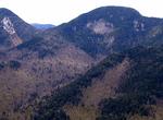
Summit Lower Wolfjaw Mountain, New York
Lower Wolfjaw Mountain is located in Essex County, New York. Landscape artist Alexander Helwig Wyant (1836–1892) named Lower Wolfjaw, together with neighboring Upper Wolfjaw Mountain, about 1870 for their appearance in profile. The mountain is the northeasternmost of the Adirondack High Peaks in the Great Range of the Adirondack Mountains. Lower Wolfjaw Mountain... -
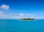
Dive or Snorkel Low Island, Queensland, Australia
Low Island North Queensland is about 25 km (16 mi) north-east of Port Douglas in Trinity Bay, North Queensland. It is around 2 hectares or 0.02 square km in size. Numerous companies run daily trips from the marina to the outer reef and the Low Isles for scuba divingand snorkelling. Low Island is part of the Low Isles. Low Isles consists of two islands, Woody Island an... -
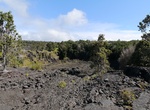
See Lua Manu Crater, Hawaii Volcanoes National Park, Big Island, Hawaii
Lua Manu Crater is approximately 330 ft. (100 meters) in diameter and 125 ft. (38 meters) deep and was formed about 200 years ago. During the 1974 eruption of Keanakāko‘i, a fissure opened east of the forested Lua Manu Crater. The lava flow entered into the crater filling it with about 50 feet (15m) of lava, however about two-thirds of this lava later drained ba...


Price: $145.00