Give us feedback!


 See all

Our philosophy is simple. We want to encourage you to dream. BIG! Then we help you plan your trip, get the most out of it while you're traveling and help you share your experience with friends.
Join Now It's FREE
Dream Packages
Duration: 6 hours
Price: $137.22
Price: $137.22
Duration: 10 hours
Price: $270.00
Price: $270.00
Duration: 9 hours
Price: $111.00
Price: $111.00
Duration: 5 hours
Price: $109.00
Price: $109.00
Related Categories
Dreams Still To Do
Checked-Off Dreams
Dreams Still To Do
Checked-Off Dreams
Advertisement
Explore Natural Wonders
-
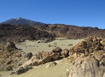
Hike Minas de San José, Tenerife Island, Canary Islands
Minas de San José is the last viewpoint along TF-21 road before starting to descend towards La Orotava. This rugged landscape is made up of lava and dark-colored rocks, a huge expanse of flat, light-colored land that looked like sand. Good place to see wildflowers in the right time of the year. -
Visit Mindanao Island, Philippines
Mindanao also commonly known as Southern Philippines, is the second-largest island in the Philippines. Mindanao and the smaller islands surrounding it make up the island group of the same name. Located in the southern region of the archipelago, as of the 2010 census, the main island was inhabited by 20,281,545 people, while the entire Mindanao island group had an esti... -
Visit Mindoro Island, Philippines
Mindoro is the seventh largest island in the Philippines by land area with a total of 10,571 km2 ( 4,082 sq.mi ) and with a total population of 1,331,473 as of 2015. It is located off the southwestern coast of Visayas and northeast of Palawan. Mindoro is divided into two provinces: Occidental Mindoro and Oriental Mindoro. San Jose is the largest settlement on the isla... -
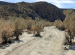
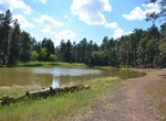
Off-road or Hike Mine Canyon, Anza-Borrego Desert State Park, California
Hike into the North Pinyon Mountains, the site of many desert mine locations. Visit a large Kumeyaay village site with hundreds of agave-roasting pits. The trail continues south from the village site, gently climbing into Mine Canyon and the Pinyon Mountains. Total elevation gain is 1,400 feet. From I-8, exit north on Hwy. 79 through Cuyamaca Rancho State Park to Jul... -
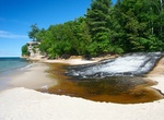
Visit Miners Beach & River, Pictured Rocks National Lakeshore, Michigan
Located about 5 miles east of Munising on Alger County Road H-58, then 6 miles north on Miners Castle Road (H11).A picnicker and beach walker's delight, Miners Beach stretches for nearly a mile along Lake Superior where waves roll in to polish beach cobbles. Miners River is popular for steelhead fishing in spring and fall. A short trail leads from the river parking ar... -
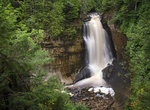
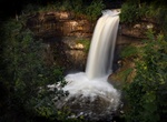
Hike to Miners Falls, Pictured Rocks National Lakeshore, Michigan
The Miners Falls parking lot is located about four miles north of H-58 off Miners Castle Road. The hike from the parking area to the waterfall is 1.2 miles round-trip. A gravel path through the northwoods leads to two overlooks. Enjoy the Miners Falls Nature Trail and views of the Miners Basin along the way. The Miners River drops about 50 feet over a sandstone outcr... -
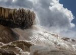
See Minerva Terrace, Mammoth Hot Springs, Yellowstone National Park, Wyoming
The cascades of travertine beside the boardwalks were formed in the 1990s. Some years, they are dry. In dry areas, you can clearly see the many layers and the varying depths. -
See Mines of Rammelsberg, Germany (UNESCO site)
The Rammelsberg is a mountain, 635 m high, on the northern edge of the Harz, south of the town of Goslar in the north German state of Lower Saxony. The mountain is the location of an important mine, the only mine which had been working continuously for over 1,000 years when it finally closed in 1988. Since 1992, the visitors' mine of Rammelsberg has become a UNESCO Wo... -
Visit Mingus Lake Day-Use/Fishing Site, Prescott National Forest, Arizona
A small lake located in the cool pines of Mingus Mountain, Mingus Lake is periodically stocked with rainbow trout. -
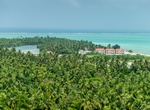
Visit Minicoy Island, Lakshadweep Archipelago, India
Minicoy, locally known as Maliku, is an island in Lakshadweep, India. Along with Viringili, it is on Maliku atoll, the southernmost atoll of Lakshadweep archipelago. Administratively, it is a census town in the Indian union territory of Lakshadweep. The island is situated 425 km west of Trivandrum, the capital city of Kerala. Minicoy is known as Maliku in the loc... -
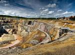
See Mining Area of the Great Copper Mountain in Falun, Sweden (UNESCO site)
The Great Copper Mountain (Swedish: Stora Kopparberget) was a mine in Falun, Sweden, that operated for a millennium from the 10th century to 1992. It produced as much as two thirds of Europe's copper needs and helped fund many of Sweden's wars in the 17th century. Technological developments at the mine had a profound influence on mining globally for two centuries. Sin... -
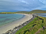
Visit Minn Beach, Shetland Archipelago, Scotland
Minn Beach is located at the south end of West Burra in the Central Mainland on Shetland. -
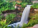
See Minnehaha Falls, Minnesota
Minnehaha Falls is a 53-foot (16 meter) waterfall located in Minneapolis in Minnehaha Park on Minnehaha Creek, a tributary of the Mississippi River located in Hennepin County, Minnesota. The Falls are located near the creek's confluence with the Mississippi River, not far from Fort Snelling, Minnesota. Minnehaha Creek extends from Lake Minnetonka in the west and flows... -
Explore Minnehaha Park, Minneapolis, Minnesota
Minnehaha Park is a city park in Minneapolis, Minnesota, United States, and home to Minnehaha Falls and the lower reaches of Minnehaha Creek. Minnehaha Park is part of the Minneapolis Park and Recreation Board which lies within the Mississippi National River and Recreation Area, a unit of the National Park Service. The park was designed by landscape architect Horace W... -
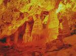
Explore Minnetonka Cave, Idaho
Minnetonka Cave is the largest limestone rock cave in the state of Idaho. It is located in Caribou-Targhee National Forest in Bear Lake County, Idaho, United States, above the village of St. Charles (located at the north end of Bear Lake). Tours through the cave are offered from Memorial Day (weather permitting) through Labor Day by Scenic Canyons Recreational Service...
Price: $164.45