Give us feedback!


 See all

Our philosophy is simple. We want to encourage you to dream. BIG! Then we help you plan your trip, get the most out of it while you're traveling and help you share your experience with friends.
Join Now It's FREE
Dream Packages
Duration: 8 days
Price: $772.57
Price: $772.57
Duration: 6 hours
Price: $137.68
Price: $137.68
Duration: 4 days
Price: $772.57
Price: $772.57
Duration: 2 days
Price: $240.61
Price: $240.61
Related Categories
Dreams Still To Do
Checked-Off Dreams
Dreams Still To Do
Checked-Off Dreams
Advertisement
Explore Natural Wonders
-
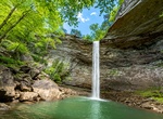
Hike to Ozone Falls, Tennessee
Ozone Falls is a waterfall located in Cumberland County, Tennessee in the Ozone Falls State Natural Area and Cumberland Trail State Park. Ozone Falls is situated along Fall Creek, which drains a short section of the Cumberland Plateau between the Crab Orchard Mountains to the west and Walden Ridge to the east. The creek flows down from its source high in the Crab Orch... -
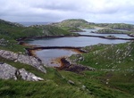
Visit Pabaigh Mòr, Isle of Lewis, Scotland
Pabay Mòr or Pabaigh Mòr is an uninhabited island in the Outer Hebrides of Scotland. Pabaigh Mòr lies off the west coast of Lewis in West Loch Roag, north of Vacsay. The island is Lewisian gneiss with a light soil. It has a number of caves, sea spouts, and natural arches. To the north, Pabay Beag is separated by a sheltered pool. The island's name... -
See Pabineau Falls, New Brunswick, Canada
Pabineau Falls is a settlement in New Brunswick, Canada. It is the administrative office of the Pabineau Mi'kmaq First Nation band government. The Pabineau First Nation is a small Mi’gmaq community situated approximately 8 kilometers south of the City of Bathurst, New Brunswick, with 280 registered band members and a land base of 1,053 acres. The Pabineau First ... -
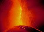
Explore Pacaya Volcano, Guatemala
Pacaya is an active complex volcano in Guatemala, which first erupted approximately 23,000 years ago and has erupted at least 23 times since the Spanish conquest of Guatemala. Pacaya rises to an elevation of 2,552 metres (8,373 ft). After being dormant for a century, it erupted violently in 1965 and has been erupting continuously since then. Much of its activity is St... -
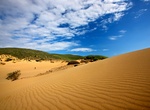
Visit Pachies Ammoudies of Lemnos (Sand dunes of Lemnos), cLemnos Island, Greece
Pachies Ammoudies of Lemnos or Sand dunes of Lemnos (Greek: Παχιές Αμμουδιές της Λήμνου or Αμμοθίνες της Λήμνου), also referred to as the Lemnos Desert, are san... -
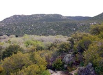
Hike Pacific Crest Trail (PCT) in Sand to Snow National Monument, California
Sand to Snow National Monument features thirty miles of the world famous Pacific Crest National Scenic Trail, the area is a favorite for camping, hiking, hunting, horseback riding, photography, wildlife viewing, and even skiing. -
Hike Pacific Crest Trail (PCT) - Kitchen Creek Falls, California
This short and easy trail is a great start for beginners or those new to the PCT. With 3.6 miles and total elevation gain of 750, this trail is relatively flat with only moderate incline. Hiking south from the Kitchen Creek parking area, the trail takes travelers to the top of the falls for great views of the valley before descending down a social trail to the bottom.... -
Visit Pacific Remote Islands Marine National Monuments (7 sites)
The Pacific Remote Islands Marine National Monument is a group of unorganized, mostly unincorporated United States Pacific Island territories managed by the Fish and Wildlife Service of the United States Department of the Interior. These remote refuges are "the most widespread collection of marine- and terrestrial-life protected areas on the planet under a single coun... -
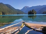
Hike Packwood Lake, Lewis County, Washington State
Packwood Lake is a freshwater lake in the Gifford Pinchot National Forest in the Cascade Mountains of Washington. It is located near the town of Packwood and is a popular day hiking and overnight camping area. The southern half of the lake lies within the Goat Rocks Wilderness area. The lake was named after William Packwood, an early settler. Packwood Lake lies at app... -
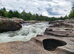
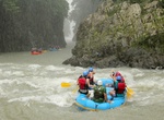
Raft or Kayak the Pacuare River, Costa Rica
The Pacuare River, or the Río Pacuare, flows approximately 108 km to the Caribbean. It is a popular location for white water rafting, whitewater kayaking and riverboarding. The rainforests that surround the river are home to exotic animal species such as jaguars, monkeys, ocelots, and a very large number of birds. Also it was considered one of the 5 nicest rive... -
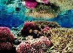
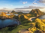
Visit Padar Island, Indonesia
Padar is a small island located between Komodo and Rinca islands within Komodo archipelago, administrated under the West Manggarai Regency, East Nusa Tenggara, Indonesia. It is the third largest island part of Komodo National Park. The Komodo archipelago is famous for Komodo dragons, giant lizards that can measure up to 3 metres (9.8 ft) long. However, unlike neighbor... -
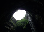
Explore Padirac Cave (Gouffre de Padirac), France
The Padirac Chasm or Gouffre de Padirac is a cave located near Gramat, in the Lotdépartement, in France. The chasm itself is approximately 99 m (325 ft) around its rim with a diameter of approximately 35 metres (115 ft). Visitors descend 75 m via a lift or a staircase before entering the cave system. The cave, at a depth of 103 metres (338 ft), contains a subte... -
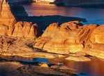
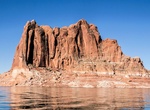
Explore Padre Bay, Lake Powell, Utah
The Padre Bay is considered to be one of the most scenic on Lake Powell. Located at mile 19 of Lake Powell, Padre Bay is the largest expanse of open water on the man made lake. Padre Bay is connected to Gunsight Butte and Cookie Jar Butte during high water periods. Nearby hiking attractions are the "weathering pits," perfectly round depressions that range between 10 t... -
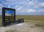
Explore Padre Island National Seashore, Texas
Padre Island National Seashore (PINS) is a National Seashore located on Padre Island off the coast of South Texas. In contrast to South Padre Island (well known for its beaches and vacationing college students), PINS is located on North Padre Island and consists of a long beach where nature is preserved. Primitive camping is available there and most of the beach is on... -
See Padres Butte, Padre Bay, Lake Powell, Utah
Padres Butte is a butte near the tip of Padre Point on the south shore of Lake Powell in San Juan County, Utah. The summit of the butte has an elevation of 4,043 feet (1,232 m). It was formerly an island in the man-made lake, but land connecting the butte with the rest of Padre Point has been exposed as the lake's water levels have declined. Padres Butte marks the sit...

Price: $615.59