Give us feedback!


 See all

Our philosophy is simple. We want to encourage you to dream. BIG! Then we help you plan your trip, get the most out of it while you're traveling and help you share your experience with friends.
Join Now It's FREE
Dream Packages
Duration: 4 days
Price: $663.61
Price: $663.61
Duration: 5 days
Price: $914.89
Price: $914.89
Duration: 14 hours
Price: $949.99
Price: $949.99
Duration: 12 hours
Price: $103.26
Price: $103.26
Related Categories
Dreams Still To Do
Checked-Off Dreams
Dreams Still To Do
Checked-Off Dreams
Advertisement
Explore Natural Wonders
-
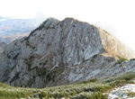
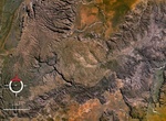
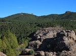
Explore Piatra Craiului Mountains, Romania
The Piatra Craiului Mountains are a mountain range in the Southern Carpathians in Romania. Its name is translated asKings' RockorThe Rock of the Prince. The mountain range is located in Brașov and Argeș counties; it is included in the Piatra Craiului National Park, which covers an area of 14,766 hectares (60 sq mi). One of the most common activities in Piatra Craiului... -
Summit Picacho del Diablo, Baja California
Picacho del Diablo is the highest peak in Baja California, measuring 3,096 metres (10,157 ft). It is alternately called Cerro de la Encantada, "Hill of the Enchanted." The peak is located in the Sierra San Pedro Martir in the Mexican state of Baja California Norte. Experienced backpackers may want to summit Picacho del Diablo. The mountain is normally approached from ... -
Explore Picacho State Recreation Area, California
Picacho State Recreation Area is located in California, USA on the lower Colorado river at the site of Picacho, a defunct gold mining town. 100 years ago Picacho was a gold mining town with 100 citizens. Today the site is a State Park, popular with boaters, hikers, anglers and campers. The park offers diverse scenery, including beavertail cactus, wild burros, bighorn... -
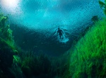
Cave Dive Piccaninnie Ponds Conservation Park, South Australia
Piccaninnie Ponds Conservation Park is a 543 ha protected area in south-eastern South Australia near Mount Gambier. The park adjoins Discovery Bay in South Australia’s Limestone Coast and conserves a wetland fed by freshwater springs in a karst landscape. It is 491 km south-east of Adelaideand 30 km south-east of Mount Gambier. Piccaninnie Ponds is a popular sit... -
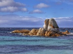
Visit Piccaninny Crater, Purnululu National Park, Western Australia
Piccaninny "crater" refers to an impact structure, the eroded remnant of a former impact crater, situated in northern Western Australia. It was named after Piccaninny Creek and lies within the Purnululu (Bungle Bungle) National Park. The site is marked by a circular topographic feature on top of the flat-topped sandstone and conglomerate Bungle Bungle Range, clearly v... -
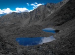
Summit Pic de Coma Pedrosa, Andorra
Coma Pedrosa is the highest mountain in the principality of Andorra. It is popular with mountain climbers, its ascent being technically straightforward, although strenuous. Several mountain lakes and tarns are found on the slopes, notably Estanys de Baiau, which lies on the western slopes, across the Spanish border. Pic de Coma Pedrosa 2,942 m 4h30, climb 1,370 m, med... -
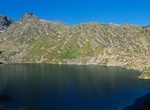
Hike Pic de Médécourbe, Andorra
Pic de Médécourbe is a mountain in Europe that sits on the western tripoint boundary of Andorra, France and Spain. It is 2,914 metres (9,560 ft) tall. It overlooks Étang de Soulcem, a large artificial lake used for hydroelectricity, and the Vicdessos valley. Pic de Médécourbe 2,914 m 4h30, climb 1,335 m, medium until the hut increasi... -
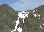
Hike Pic de Sanfonts, Andorra
Pic de Sanfonts is a mountain in the Pyrenees on the border of Spain and northwest Andorra. The nearest town is Arinsal, La Massana. It is a subpeak of, and 1.2 km southwest of, Coma Pedrosa (2942 m), the highest mountain in Andorra. Treks from Arinsal (1,500 m) - Pic de Sanfons (2,888 m, 4h45, climb 1,310 m, medium until the hut, difficult on the ridge). View on the ... -
Visit Picketwire Canyon, Comanche National Grassland, Colorado
Picketwire Canyon is about 400 feet (120 m) deep and contains the Purgatoire River track site, one of the largest dinosaur track-ways in the world, in the Morrison Formation. More than 1,300 tracks of Brontosaurs and Allosaurs 150 million years old are preserved in the rocks. The canyon and the dinosaur tracks are accessible by a hiking, biking, and horseback trail th... -
Visit Picnic Rocks & Deep Creek Campground, Mount William National Park, Tasmania
Take Eddystone Point Road to Deep Creek Road to Picnic Rocks & Deep Creek Campground. -
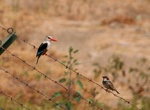
Birding at Pico da Antónia, Santiago, Cape Verde
Pico da Antónia is Santiago's tallest mountain located in the central part of the island in Cape Verde. The mountain is part of the protected area Parque Natural de Rui Vaz e Serra de Pico de Antónia. The mountain is entirely of volcanic origin. The towns Picos and Assomada lie close to the mountain. The area around the peak has been identified by BirdLi... -
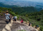
Summit Pico da Tijuca, Rio de Janeiro, Brazil
Pico da Tijuca is a mountain in the city of Rio de Janeiro, Brazil. The mountain is the most prominent peak of the Rio de Janeiro City urban zone. Pico da Tijuca is part of the 3,958.41 hectares (9,781.4 acres) Tijuca National Park protected area, established in 1961. There are stairs cut in the rock to reach the top of the peak. -
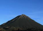
Explore Pico de Fogo, Cape Verde
Pico de Fogo - an active volcano on Fogo that has created a unique landscape best explored on foot or horseback. -
Summit Pico de las Nieves, Gran Canaria, Canary Islands
Pico de las Nieves is the second highest peak on the island of Gran Canaria, Canary Islands, Spain. Its height is 1,949 metres (6,394 ft) above sea level. It is of volcanic origin (stratovolcano). On its slopes, Canary Islands Pine was reintroduced in the 1950s. Traditionally, Pico de las Nieves has been considered the highest peak on the island of Gran Canaria; howev... -
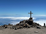
Summit Pico de las Nieves (La Palma Island), Canary Islands
The route to Pico de la Nieve is located in the famous Caldera de Taburiente and is one of the must- see attractions on the island of La Palma , Canary Islands. A peak of 2239 meters that is really one of the many points that make up the great crater of the island. For this reason, the views are exceptional and a great option to add to your visit to Roque de los Mucha...

Price: $615.59