Give us feedback!


 See all

Our philosophy is simple. We want to encourage you to dream. BIG! Then we help you plan your trip, get the most out of it while you're traveling and help you share your experience with friends.
Join Now It's FREE
Dream Packages
Duration: 3 days
Price: $707.56
Price: $707.56
Duration: 3 days
Price: $615.59
Price: $615.59
Duration: 2 days
Price: $469.00
Price: $469.00
Duration: 3 days
Price: $604.38
Price: $604.38
Related Categories
Dreams Still To Do
Checked-Off Dreams
Dreams Still To Do
Checked-Off Dreams
Advertisement
Explore Natural Wonders
-
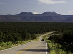
See the Bears Ears, Utah
The Bears Ears are a pair of buttes located in San Juan County in the southeastern Utah, United States. They are protected as part of and the namesake of the Bears Ears National Monument, managed by the Bureau of Land Management and United States Forest Service. The Bears Ears are bordered on the west by Dark Canyon Wilderness and Beef Basin, on the east by Comb Ridge... -
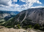
Explore Beartooth Mountains, Montana
The Beartooth Mountains are located in south central Montana and northwest Wyoming, U.S. and are part of the 900,000 acre (3,600 km²) Absaroka-Beartooth Wilderness, within Custer, Gallatin and Shoshone National Forests. The Beartooths are the location of Granite Peak, which at 12,807 feet (3,904 m) is the highest point in the state of Montana. The mountains are j... -
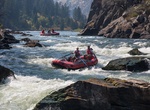
Whitewater Raft/Kayak Bear Trap Canyon (Madison River), Montana
Blue-ribbon trout stream, tubers’ delight, hikers’ paradise—whatever you call it, the Madison River is one of the most scenic spots in southwestern Montana. The Bureau of Land Management’s Dillon Field Office manages more than a dozen recreation sites along the gin-clear waters of the river. The Madison River starts where the Gibbon and Firehol... -
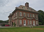
Visit Beaulieu House and Gardens, Co. Louth, Ireland
Beaulieu House and Gardens is an estate in Drogheda, Co. Louth, Republic of Ireland. It was thought to be built in the 1660s, although later research seems to suggest it was built around 1715, and it includes a terraced walled garden. It is located 2 miles (3.2 km) east of Drogheda less than half a mile from the estuary of the River Boyne. Guided tours of the estate a... -
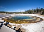
See Beauty Pool, Yellowstone National Park, Wyoming
Beauty Pool is located in Upper Geyser Basin of Yellowstone National Park. -
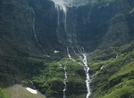
See Beaver Chief Falls & Lincoln Lake, Glacier National Park, Montana
Lincoln Lake is located along the Gunsight Pass Trail in Glacier National Park. Lincoln Lake is .25 miles (0.40 km) downstream from Lake Ellen Wilson but sits more than 1,300 feet (400 m) lower in elevation. A series of cascades including Beaver Chief Falls can be found between the two lakes. There is a campground at the western end of Lincoln Lake. -
Explore Beaver Creek Swamp, Alabama
Beaver Creek Swamp is the name of a tupelo gum swamp located ten miles northeast of Decatur, Alabama in Limestone County, Alabama. While this type of swamp is usually located in the coastal plain, Beaver Creek Swamp is an exception; it is located in the Interior Low Plateaus region. It is part of the Wheeler National Wildlife Refuge. Star Study Academy helped build th... -
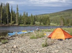
Raft or Kayak Beaver Creek Wild and Scenic River, Alaska
Those folks seeking true adventure can find it floating Beaver Creek Wild and Scenic River. Beaver Creek Wild and Scenic River is a Class I, clear water river, with only a few short sections of class II water that flows past jagged limestone peaks in the White Mountains National Recreation Area and through the Yukon Flats National Wildlife Refuge before joining the Yu... -
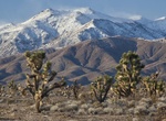
See Beaver Dam Wash Joshua Trees, Utah
One of the few "old growth 'Joshua Tree' forests" left along the historic road between Salt Lake and California. -
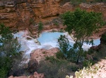
See Beaver Falls, Arizona
Beaver Falls is arguably the fourth set of falls on Havasu Creek, although many claim that it is not a waterfall, but merely a set of small falls that are located close to each other. The falls are located approximately 6 miles (9.7 km) downstream of Supai, and are the most difficult to access. To reach the falls, follow the trail down to Mooney Falls. After descendin... -
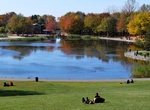
Explore Beaver Lake, Mount Royal, Montreal, Quebec, Canada
The Beaver Lake is an artificial basin fitted in 1938 on a former swamp located on the Mount Royal, in Montreal, Quebec, Canada. It was designed by architect Frederick Todd. It takes its name from an old beaver dam discovered during the work. About 200 metres (660 ft) by 150 metres (490 ft), Beaver Lake is shaped like a four-leafed clover. It was traditionally used an... -
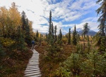
Hike Beaver Pond Loop Trail, Lake Clark National Park, Alaska
Any hike in the Tanalian Trail system can be made into a loop by returning on the Beaver Pond Trail. This trail meanders through quiet birch groves and past an old beaver pond where shorebirds nest in the early summer. Benches overlook the beaver pond offering a quiet place for reflection.The trek to the Tanalian Falls can also be started on this trail. The Beaver Pon... -
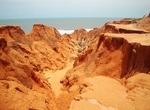
Explore Beberibe, Ceará
Beberibe is a municipality in the state of Ceará in Brazil. Its estimated population in 2006 is 46,439. The municipality was created on June 5, 1892, and incorporated July 18, 1892. The name 'Beberibe' means "where the sugar cane grows". The headquarters of the municipality are located in the town of Beberibe, which is situated about 80 km SE of Fortaleza, the ... -
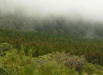
Explore Bébour-Bélouve Forest, Réunion
Bébour-Bélouve on Réunion island is an old volcano and sponge forests at the base of Piton des Neiges (Snow Peak), a massive 3,070 m (10,069 ft) volcano. The Bebour plateau is covered principally by primary forest with tree ferns above the forest canopy. With twisted branches and trees covered in a multitude of epiphytes, the foliage gives the imp... -
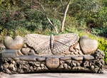
Visit Bebra Gardens & Sadie's Bench, Knaresborough, North Yorkshire, England
Bebra Gardens, formerly the Moat Gardens, renamed after Knaresborough's twin town in Germany. It's located near Knaresborough Castle ruins.

Price: $164.45