Give us feedback!


 See all

Our philosophy is simple. We want to encourage you to dream. BIG! Then we help you plan your trip, get the most out of it while you're traveling and help you share your experience with friends.
Join Now It's FREE
Dream Packages
Duration: 9 hours
Price: $88.47
Price: $88.47
Duration: 3 days
Price: $615.59
Price: $615.59
Duration: 6 hours
Price: $137.68
Price: $137.68
Duration: 10 hours
Price: $133.63
Price: $133.63
Related Categories
Dreams Still To Do
Checked-Off Dreams
Dreams Still To Do
Checked-Off Dreams
Advertisement
Explore Natural Wonders
-
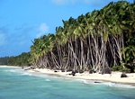
Visit Pulau Panjang (West Island), Cocos (Keeling) Islands
West Island (Pulu Panjang), part of the South Keeling Islands, is the capital of the Cocos (Keeling) Islands, an Australian external territory in the Indian Ocean. The population is roughly 120 making it the third smallest capital in the world, and consists mainly of Europeans. It is less populous than Home Island, the only other inhabited island. West Island was part... -
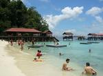
Explore Pulau Payar Marine Park, Malaysia
Pulau Payar is one of the many islands off mainland Kedah in the Strait of Malacca. It is situated south of Langkawi, a more famous archipelago. Pulau Payar's status as a marine park offers protection for its diverse marine life. Pulau Payar is also a snorkeling and diving site famous for its corals. The Pulau Payar Marine Park is situated in the northern part of the ... -
Visit Pulau Penyengat, Sumatra, Indonesia
Pulau Penyengat is a small island in the City of Tanjungpinang , Riau Islands , which is approximately 2 km from the city center. The island is 2,000 meters long and 850 meters wide, approximately 35 km from Batam Island . This island can be reached from the center of Tanjung Pinang City by motorized boat or better known as pompong which takes about 15 minutes. Penyen... -
Visit Pulau Tikus (Direction Island), Cocos (Keeling) Islands
Direction Island is located in the Cocos (Keeling) Islands group. A slipway and tank associated with the flying boat and sea rescue presence on the island in the early twentieth century are listed on the Australian Commonwealth Heritage List. -
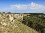
Visit Pulicchio di Gravina, Puglia, Italy
Pulicchio di Gravina (in the local dialect Pulícchie or Pulidde) is the second-largest doline in the Murge plateau (in Apulia, southern Italy) after Pulo di Altamura. It falls into the territory of Gravina in Puglia, located about 10 kilometers (6.2 mi) north of the latter, close to the border with Altamura's territory. It shares the local toponym pulo with ... -
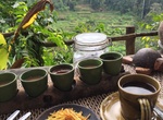
Drink coffee at Pulina Coffee Plantation, Bali, Indonesia
Bali Pulina Coffee Plantation is a place to learn about the process of making the most unique coffee in the world. You can see there other types of trees too such as cocoa, palm trees and others. You can sit at the rice terrace to enjoy the view while sipping the coffee. -
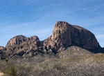
Rock Climb Pulliam Bluff, Big Bend National Park, Texas
Pulliam Bluff is roughly three to five technical pitches with the hardest around 5.7. Approcach is a creek bad from the Maple Canyon Trail. -
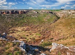
Visit Pulo di Altamura, Apulia, Italy
Pulo di Altamura is a doline located on the Murge plateau (Apulia, Italy). It is the largest doline in that region and it is located about 6 kilometers (3.7 mi) north-west of the city of Altamura. It shares the local toponym pulo with other large dolines of the region, i.e. Pulicchio di Gravina, Pulo di Molfetta and Pulicchio di Toritto. The perimeter, measured o... -
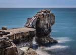
See Pulpit Rock, Portland, Dorset, England
Pulpit Rock is a coastal feature at Portland Bill, the southern tip of the Isle of Portland, Dorset, England. Intended to have the appearance of an open bible leaning on a pulpit, Pulpit Rock was formed in the 1870s after a natural arch was cut away by quarrymen at Bill Quarry, and the leaning slab was added. As a quarrying relic, the rock is similar to that of Nicode... -
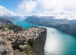
Stand on Pulpit Rock (Preikestolen), Norway
Preikestolen or Prekestolen, also known by the English translations of Preacher's Pulpit or Pulpit Rock, and by the old local name Hyvlatonnå (“the carpenter-plane’s blade”), is a massive cliff 604 metres (1982 feet) above Lysefjorden, opposite the Kjerag plateau, in Forsand, Ryfylke, Norway. The top of the cliff is approximately 25 by 25 metre... -
Visit Pulu Maria (West Cay), Cocos Islands (Keeling)
Pulu Maria, one of the 27 islands of the Cocos (Keeling) Islands, lies off the southeast end of West Island. Captain Ballard is reported to have been an early settler who lived on Home Island in the mid-nineteenth century. He lived with his family on the Island. His two children, Dick and Maria were lost from the shores of the island known as Pulu Maria, which was app... -
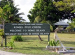
Visit Pulu Selma (Home Island), Cocos Islands (Keeling)
Home Island, also known locally as Pulu Selma, is one of only two permanently inhabited islands of the 26 islands of the Southern Atoll of the Cocos (Keeling) Islands, an Australian Overseas Territory in the central-eastern Indian Ocean. It is 95 hectares (230 acres) in area and contains the largest settlement of the territory, Bantam, with a population of about 500 C... -
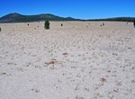
See Pumice Desert, Oregon
Pumice Desert is a barren landscape about 6 miles north of Crater Lake Caldera. The site has a significant deposit of pumice - it is over 100 feet thick. The material fills a pre-existing glacial valley and was delivered via a large pyroclastic flow (ash & pumice flow) during Mazama's 7.7 ka eruption. Pyroclasts include light-colored rhyodacite pumice and darker-c... -
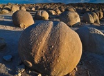
Visit Pumpkin Patch, Ocotillo Wells, California
Pumpkin Patch is located within Ocotillo Wells State Vehicular Recreation Area. It can be accessed via the Arroyo Salado Trail, Cut Across Trail or from a few trails from Ocotillo Wells. Pumpkin Patch is a remote field of round rocks is a popular destination in Ocotillo Wells. Created long ago when the climate here was wet, then shaped through years of erosion, the ... -
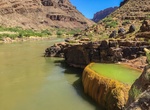
See Pumpkin Spring, Colorado River, Arizona
At mile 212.9 down the Coloado River is a unusual formation is known as Pumpkin Spring. The bowl looks like the sides of a gigantic pumpkin. It might look like an inviting place for a soak, but in reality, contains the most poisonous water in the canyon. While the pool may appear to be full of mineral-rich, hot springs goodness, and the pumpkin-shaped bowl seems hypno...
Price: $337.00