Give us feedback!


 See all

Our philosophy is simple. We want to encourage you to dream. BIG! Then we help you plan your trip, get the most out of it while you're traveling and help you share your experience with friends.
Join Now It's FREE
Dream Packages
Duration: 3 days
Price: $489.00
Price: $489.00
Duration: 2 days
Price: $340.00
Price: $340.00
Duration: 13 hours
Price: $133.43
Price: $133.43
Duration: 3 hours 30 minutes
Price: $179.75
Price: $179.75
Related Categories
Dreams Still To Do
Checked-Off Dreams
Dreams Still To Do
Checked-Off Dreams
Advertisement
Explore Natural Wonders
-
Explore Salar de Atacama (Atacama Salt Flat), Chile
Salar de Atacama is the largest salt flat in Chile. It is located 55 km (34 mi) south of San Pedro de Atacama, is surrounded by mountains, and has no drainage outlets. In the east it is enclosed by the main chain of the Andes, while to the west lies a secondary mountain range of the Andes called Cordillera de Domeyko. Large volcanoes dominate the landscape, including ... -
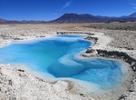
Explore Salar de Pedernales, Atacama, Chile
Salar de Pedernales is a large salt flat in the Atacama Region of Chile. It lies east of the Cordillera Domeyko at an elevation of 3,370 metres (11,060 ft). The salt flat has an irregular shape and consists mostly of gypsum and rock salt, with an area of 0.6 square kilometres (0.23 sq mi)-1.1 square kilometres (0.42 sq mi) covered by open water. During the late Pleist... -
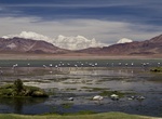
Explore Salar de Tara (Tara Salt Flat), Chile
Tara is located 120 kilometres east of San Pedro de Atacama and 440 kilometres northeast of Antofagasta. In 1996, Salar de Tara (Tara Salt Flat) was designated a Wetland of International Importance by the Ramsar Convention. It features both permanent and seasonal lakes. The largest of these is Tara Lake, which is fed by the Zapaleri River. The flora is characterized b... -
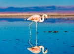
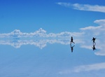
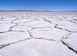
Explore Salar de Uyuni Salt Flats, Bolivia
Salar de Uyuni (or Salar de Tunupa) is the world's largest salt flat. It is located in the Potosí and Oruro departments in southwest Bolivia, near the crest of the Andes, and is elevated 3,656 meters (11,995 ft) above the mean sea level. The Salar was formed as a result of transformations between several prehistoric lakes. It is covered by a few meters of salt ... -
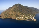
Explore Salina Island, Italy (UNESCO site)
Salina is the second largest island in the archipelago. Salina is divided between three comuni: Santa Marina on the eastern coast, Malfa to the north, and Leni to the south-west. From Leni down towards the sea are the villages of Valdichiesa and Rinella. The other smaller villages are Capo Faro, Pollara and Lingua. The following sites are on the idland: The salt lake... -
Visit Salinas Grandes, Argentina
The Salinas Grandes is a large salt flat in central-northern Argentina, spanning the borders of four provinces (Córdoba, Catamarca, La Rioja and Santiago del Estero), at an average altitude of 170 metres above sea level, at the foot of the Sierras de Córdoba mountain range. It covers an area of 6,000 km2 (2,300 sq mi). -
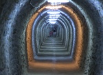
Explore Salina Turda (Turda Salt Mine), Romania
Salina Turda is a salt mine situated in Turda, Transylvania, Romania. Salt was first extracted here during the antiquity and the mine continuously produced table salt from the Middle Ages (the mine being first mentioned in 1075) to the early 20th century (1932). Since 1992, Salina Turda has been a halotherapy center and a popular tourist attraction. At 200 meters (65... -
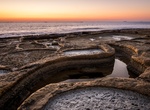
Visit Saline, Wied il-Għajn, Malta
One of the few salt pans to find on the island, especially in the southern region. They are not in use anymore but add to the beautiful promenade. -
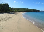
Visit Saline Bay & Beach, Mayreau, Grenadines
Saline Bay provides good access to the island of Mayreau. There is a clean beach and good access to snorkeling. This beautiful 1-mile (1½-km) crescent of pure white sand on the southwestern coast of Mayreau has no facilities but up the hill there are several resturants and shops. -
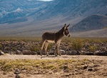
Explore Saline Valley, Death Valley National Park, California
Saline Valley is a large, deep, and arid valley in the northern Mojave Desert of California. Most of it became a part of Death Valley National Park when the park expanded in 1994. This area had previously been administered by the BLM. It is located northwest of Death Valley proper, south of Eureka Valley, and east of the Owens Valley. The valley's lowest elevatio... -
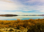
See Saline Valley Dry Lake Bed, Death Valley National Park, California
Saline Valley Dry Lake Bed is located in the middle of the Saline Valley in Death Valley National Park, California. In the winter it can have water. -
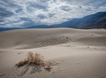
Hike Saline Valley Sand Dunes, Death Valley National Park, California
Saline Valley Sand Dunes are low dunes surrounding a dry lake located in Death Valley National Park, California. The area is large but pretty isolated. Sandboarding is not allowed. -
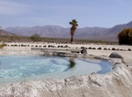
Camp & Soak at Saline Valley Upper Warm Springs, Death Valley National Park, California
The Saline Valley Warm Springs in Death Valley National Park have become controversial in recent years. The improvements would have violated Park Service policy if they had taken place today, and nudity is against park regulations. There has been compromise so far; a park host is always on duty, visitors are limited to 30 days per year, and the springs do not appear o... -
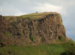
See View from Salisbury Crags, Holyrood Park, Edinburgh, Scotland
Salisbury Crags are a series of 46-metre (151 ft) cliffs at the top of a subsidiary spur of Arthur's Seat which rise on the west of Holyrood Park. Below the foot of the cliffs is a large and steep talus slope falling to the floor of Holyrood Park with a track known as the Radical Road running in the space between the two. This track was given its name after it was p... -
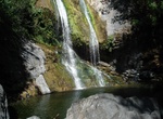
See Salmon Creek Falls, Big Sur, California
Salmon Creek Falls is a 120-foot (36 meter) waterfall in the southern Big Sur region of Monterey County, California. The falls are located along California State Route 1 about 2.9 mi (4.7 km) northwest of Ragged Point and lies within the Monterey Ranger District of the Los Padres National Forest and Silver Peak Wilderness. The falls are located along California State ...
Price: $606.00