Give us feedback!


 See all

Our philosophy is simple. We want to encourage you to dream. BIG! Then we help you plan your trip, get the most out of it while you're traveling and help you share your experience with friends.
Join Now It's FREE
Dream Packages
Duration: 2 days
Price: $469.00
Price: $469.00
Duration: 3 days
Price: $489.00
Price: $489.00
Duration: 10 hours
Price: $133.00
Price: $133.00
Duration: 3 hours
Price: $103.11
Price: $103.11
Related Categories
Dreams Still To Do
Checked-Off Dreams
Dreams Still To Do
Checked-Off Dreams
Advertisement
Explore Natural Wonders
-
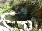
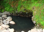
Visit Big Caliente Hot Springs, Santa Barbara, California
Big Caliente Hot Springs are a grouping of thermal mineral springs located in the Los Padres National Forest of California. The hot spring water emerges at 115 °F from a bluff and flows into a large, deep primitive rock and concrete soaking pool. The temperature of the water can be controlled by adjusting diversion valves. Another primitive soaking pool is located... -
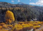
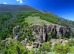
Explore Big Cottonwood Canyon, Utah
Big Cottonwood Canyon is a canyon in the Wasatch Range 12 miles (19 km) southeast of Salt Lake City in the U.S. state of Utah. The 15-mile (24 km)-long canyon provides hiking, biking, picnicking, rock-climbing, camping and fishing in the summer. Its two ski resorts, Brighton and Solitude, are popular among skiers and snowboarders. The canyon is accessed by The Big Cot... -
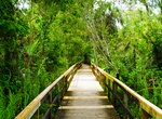
Explore Big Cypress Bend, Fakahatchee Strand Preserve State Park, Florida
A part of Fakahatchee Strand Preserve State Park, it features the largest grove of royal palm trees in the country. -
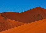
Climb Big Daddy Dune, Namib-Naukluft National Park, Namibia
Big Daddy is the highest dune in the Sossusvlei area, at about 325 meters. Big Daddy is located past Sossusvlei proper, near Deadvlei. It faces another very high dune known as "Big Mama". Big Daddy is distinct from Dune 7 in Namibia, near Walvis Bay. -
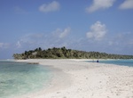
Visit Bigej Island, Kwajalein Atoll, Marshall Islands
Bigej or Begej Island is part of Kwajalein Atoll in the Ralik Chain in the Republic of the Marshall Islands (RMI), 2,100 nautical miles (3900 km) southwest of Honolulu, Hawaii. The remains of a fuel tank farm built by the US Navy in 1944 are still present on the island. Bigej is not part of the Reagan Test Site. Bigej is uninhabited and has no buildings on it but many... -
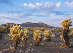
Explore Bigelow Cholla Garden Wilderness, Mojave Trails National Monument, California
The Bigelow Cholla Garden Wilderness is in the eastern Mojave Desert and within Mojave Trails National Monument, located in San Bernardino County, California. The wilderness lies in the northern end of the Sacramento Mountains, east of the Piute Mountains and 18 miles (29 km) west of Needles, California, along Interstate 40 as its northern border. The wilderness cover... -
Relax in Bigelow (Deer Creek) Hot Springs, Oregon
Bigelow (Deer Creek) Hot Springs is located along the McKenzie River north of Belknap Springs on Hwy 126. Due to its proximity to the river, it is usually made too cool in the winter by the frigid river water. -
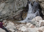
Hike to Big Falls, Forest Falls, San Bernardino National Forest, California
Big Falls trail is a short easy hike to a 5-tiered waterfall located in a beautiful mountain canyon filled with giant redwood trees. The trailhead is reached by turning east off Highway 38 to Valley of the Falls Road in Forest Falls. Continue through the community to the top end of the road. Big Falls trailhead will be the first main parking lot on the left, immedia... -
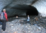
Visit Big Four Ice Caves, Washington
Big Four Mountain is a mountain in the Cascade Range of Washington, located 21 miles (34 km) east of Granite Falls. The mountain is about 6,180 ft (1,880 m) high. At the bottom of its steep, 4,200 ft (1,300 m) high north face, debris piles form from avalanches and are able to remain there year round because of the continuous shade provided by the mountain. At an eleva... -
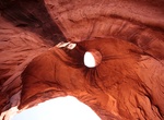
See Big Hogan Arch, Monument Valley, Arizona
Big Hogan Arch is a cave natural arch located within the boundaries of Monument Valley Navajo Tribal Park. It is located very close to Moccasin Arch. A Navajo guide is required for any visitation. -
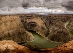
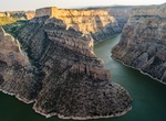
Explore Bighorn Canyon National Recreation Area, Wyoming & Montana
A landscape of sheer cliffs towering 1,000 feet above a ribbon of blue water. World class fishing and a place where wild horses still run free. Bighorn Canyon is a place where imagination meets reality. Bighorn Canyon has unrivaled recreation possibilities. Bighorn Canyon National Recreation Area was established by an act of Congress on October 15, 1966, following the... -
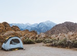
Camp at Bighorn Cove, Colorado River, Arizona
Come by water or by land to this cove for a secluded camp spot. If you’re going to drive in, a 4WD vehicle is recommended. How to Get There: Bighorn Cove is located on the Arizona side of Lake Mohave, south of Willow Beach. It can be accessed from the water or via Bighorn Cove Road from Willow Beach. -
Explore Bighorn Lake, Montana & Wyoming
Bighorn Lake is a reservoir behind Yellowtail Dam within the Bighorn Canyon National Recreation Area, located in southern Montana and northern Wyoming. The reservoir is 40 mi (64 km) south of Billings, Montana. It stretches the entire 72 mi (115 km) length of the Bighorn Canyon at full pool. The Lake was created by the 1965 construction of Yellowtail Dam on the Bighor... -
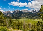
Explore Bighorn Mountains, Wyoming & Montana
The Bighorn Mountains are a mountain range in northern Wyoming and southern Montana in the United States, forming a northwest-trending spur from the Rocky Mountains extending approximately 200 miles (320 km) northward on the Great Plains. They are separated from the Absaroka Range, which lie on the main branch of the Rockies in western Wyoming, by the Bighorn Basin. T... -
Explore Bighorn National Forest, Wyoming
The Bighorn National Forest is a U.S. National Forest located in northern Wyoming, United States and consists of over 1.1 million acres (4,500 km2). Created as a US Forest Reserve in 1897, it is one of the oldest government-protected forest lands in the U.S. The forest is well east of the continental divide and extends from the Montana border for a distance of 80 mile...
Price: $772.57