Give us feedback!


 See all

Our philosophy is simple. We want to encourage you to dream. BIG! Then we help you plan your trip, get the most out of it while you're traveling and help you share your experience with friends.
Join Now It's FREE
Dream Packages
Duration: 12 hours
Price: $103.26
Price: $103.26
Duration: 10 hours
Price: $270.00
Price: $270.00
Duration: 6 hours
Price: $137.68
Price: $137.68
Duration: 2 days
Price: $337.00
Price: $337.00
Related Categories
Dreams Still To Do
Checked-Off Dreams
Dreams Still To Do
Checked-Off Dreams
Advertisement
Explore Natural Wonders
-
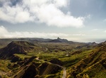
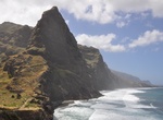
Visit Santiago, Cape Verde
Santiago (Portuguese for “Saint James”), orSantiaguin Cape Verdean Creole, is the largest island of Cape Verde, its most important agricultural centre and home to half the nation’s population. Santiago is located between the islands of Maio (40 kilometres (25 miles) west) and Fogo (50 kilometres (31 miles) east) and is one of the Sotavento. It w... -
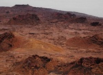
Explore Santiago Island, Galápagos
Santiago Island is an island of the Galápagos Islands. It is also known as San Salvador, named after the first island discovered by Columbus in the Caribbean Sea (see San Salvador Island), or as James Island. The island, which consists of two overlapping volcanoes, has an area of 585 km² and a maximum altitude of 907 meters, atop the northwestern shield vo... -
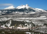
Explore Santiam Pass, Oregon
Santiam Pass is a 4,817-foot (1,468 m) mountain pass in the Cascade Range in central Oregon in the United States. It is located on the border between Linn and Jefferson counties, about 18 mi (29 km) northwest of Sisters, between the prominent volcanic horns of Three Fingered Jack to the north and Mount Washington to the south. Several other smaller volcanoes, includin... -
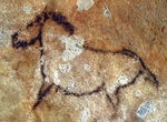
Visit Santimamiñe Cave, Spain (UNESCO site)
Santimamiñe cave, Kortezubi, Biscay, Basque Country is one of the most important archaeological sites of the Basque Country, including a nearly complete sequence from the Middle Paleolithic to the Iron Age. Its complete sequence includes the following cultures: Mousterian Chatelperronian Aurignacian Gravettian Solutrean Magdalenian Azilian Plus unc... -
Visit Santo Antão, Cape Verde
Santo Antão (Portuguese for "Saint Anthony"), orSontontonin Cape Verdean Creole, is the westernmost and largest of the Barlavento islands of Cape Verde. The nearest main island is São Vicente to the southeast, separated by a channel named Canal de São Vicente. It is the westernmost large island in Cape Verde and the continent of Africa, and the se... -
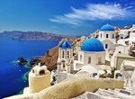
Visit Santorini Island (Thíra), Greece
Walking through the narrow streets of the picturesque Greek Island of Santorini you will likely smell a heavenly mixture of olive oil, mint, and wine in the air. The islands whitewashed houses framed by bougainvillea spill down the rim of this ancient volcanic crater. You’d never really know that a volcano last erupted on this island in 1956. Though some of the ... -
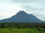
Explore Santubong National Park, Sarawak, Malaysia
Mount Santubong is a mountain in the Malaysian state of Sarawak. It is located about 35 km north of the state capital Kuching. In 1855 a British naturalist, Alfred Russel Wallace who was staying at Santubong while collecting specimens in Sarawak, wrote a paper while called "Sarawak Law" which can be considered as a precursor to the biological theory of evolution. Moun... -
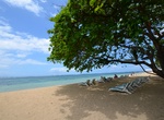
Relax on Sanur Beach, Bali
Sanur is a stretch of beach in southeast Bali, about 30 minutes drive from Ngurah Rai International Airport. The northern part of Sanur beach was used as the landing site for the Dutch invasion troops during the Dutch intervention in Bali (1906). During World War II, Sanur was again the entry point through which the Japanese forces landed to occupy the island of Bali... -
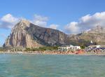
Visit San Vito Lo Capo, Sicily, Italy
San Vito Lo Capo is a town andcomunein North-Western Sicily, Italy, administratively part of the province of Trapani. It has 3,914 inhabitants as of 2004. The small town is located in a valley between spectacular mountains, and is home to a public beach popular with local vacationers. The town's primary industries are tourism and agriculture, particularly olive groves... -
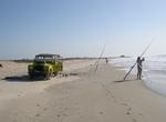
Relax on Sanyang Beach, Gambia
Sanyang Beach. One of the most beautiful beaches in The Gambia. Rainbow Beach Bar is a great place to spend the day, and also has a few affordable rooms for staying the night. Public transport leaves from Serrakunda and Brikama regularly, and private taxis can also be hired for day trips. -
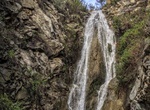
Hike to San Ysidro Falls, Santa Barbara, California
After a big rain, the falls are very dramatic. In drier months, it’s pretty chill and peaceful as can be. The trail follows the creek for two miles and then makes a steep climb out of the canyon to East Camino Cielo Road. Take San Ysidro Road to East Valley Road. Turn right on East Valley Rd. travel five miles to Park Lane and turn left. Trailhead is just befor... -
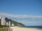
Relax at São Conrado Beach, Rio de Janeiro, Brazil
São Conrado Beach is located in the Rio neighborhood of São Conrado, Rio de Janeiro, Brazil. -
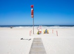
Visit São Jacinto Dunes Nature Reserve, Aveiro, Portugal
São Jacinto Dunes Nature Reserve is a nature reserve (area for the protection of habitats , flora and fauna wild) Portuguese , and is located at the tip of the peninsula that goes from Ovar and San Jacinto . To the west is the Atlantic Ocean and to the east the Ria de Aveiro . This protected area of about 600 hectares was created in 1979 and is part of the Ri... -
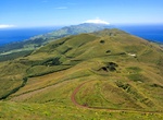
Visit São Jorge Island, Azores
São Jorge is a Portuguese island in the central Azorean archipelago of Portugal. It is separated from its nearest neighbors (Pico and Faial islands) by a 15 km strait (consequently, the three islands are sometimes referred to colloquially as the "Triangle" group or just "The Triangle"). São Jorge is a relatively long thin island with tall cliffs, and whe... -
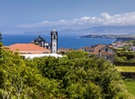
Visit São Miguel Island, Azores, Portugal
São Miguel Island is also referred to locally as "The Green Island", is the largest and most populous island in the Portuguese archipelago of the Azores. The island covers 760 km2 (290 sq mi) and has around 140,000 inhabitants, with 45,000 of these people resident in the largest city in the archipelago: Ponta Delgada. São Miguel is bisected by many fault...
Price: $606.00