Give us feedback!


 See all

Our philosophy is simple. We want to encourage you to dream. BIG! Then we help you plan your trip, get the most out of it while you're traveling and help you share your experience with friends.
Join Now It's FREE
Dream Packages
Duration: 7 to 9 hours
Price: $109.00
Price: $109.00
Duration: 6 hours
Price: $137.68
Price: $137.68
Duration: 2 hours
Price: $604.48
Price: $604.48
Duration: 12 hours
Price: $120.00
Price: $120.00
Related Categories
Dreams Still To Do
Checked-Off Dreams
Dreams Still To Do
Checked-Off Dreams
Advertisement
Explore Natural Wonders
-
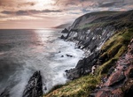
Visit Slea Head, Ireland
Slea Head is a promontory in the westernmost part of the Dingle Peninsula, located in the barony of Corca Dhuibhne in southwest County Kerry, Ireland. It belongs to Munster's province (County Kerry) and is served by the R559 road; the nearest villages are Ballyickeen and Coumeenoole. It is a well known and recognised landmark and also a very scenic viewpoint, with a d... -
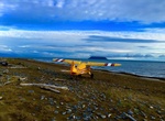
Explore Sledge Island, Alaska Maritime National Wildlife Refuge
Sledge Island, or Ayak Island, is a small island in the Bering Sea. It is located 5.3 mi (8.5 km) from the southwestern shore of the Seward Peninsula, off the shores of Alaska. Sledge Island is of volcanic origin and is only 1.6 miles (2.6 km) across. The average elevation is 410 feet/125 meters. Administratively this island belongs to the Nome Census Area, Alaska. Th... -
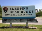
Explore Sleeping Bear Dunes National Lakeshore, Lake Michigan, Michigan
Sleeping Bear Dunes National Lakeshore is a United States National Lakeshore located along the northwest coast of the Lower Peninsula of Michigan in Leelanau County and Benzie County. The park covers a 35-mile (60-km) stretch of Lake Michigan's eastern coastline, as well as North and South Manitou Islands. This northern Michigan park was established primarily because ... -
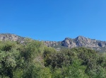
Hike Sleeping Giant (Uyuyan Dev), Kaş, Turkey
Sleeping Giant (Uyuyan Dev) is the rocky ridge above the cliffs. You can hike up from the east, the direct approach from town is steep and hazardous. -
Visit Slender West Lake, Yangzhou, China
Slender West Lake, also known by its Chinese name Shouxihu and by other names, is a scenic lake in Hanjiang District in central Yangzhou, China. The lake developed from the city moats of Tang-era Yangzhou. During the Qing dynasty, its banks were the site of numerous estates for the area's wealthy officials and salt merchants. The lake and some of its attractions have ... -
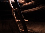
Hike Slickhorn Canyon (Perfect Kiva), Cedar Mesa, Utah
Slickhorn Canyon drains the southwest side of Cedar Mesa and eventually meeting the San Juan River. The upper part splits into four forks, all containing Anasazi ruins and pictographs. The first (northernmost) fork of Slickhorn Canyon contains the most ruins, some small, and including the most famous site in the area, Perfect Kiva. The second fork has only a couple of... -
See Slick Rock Falls, North Carolina
Slick Rock Falls is a waterfall in Western North Carolina, located near Brevard. The falls are open to the public and are accessible by traveling on U.S. Highway 276, approximately 5.2 miles north of the intersection of 276, U.S. Highway 64, andNC Highway 280 in Brevard, North Carolina. Turn left onto Forest Road 475 and go 1.5 miles, and turn right onto Forest Road 4... -
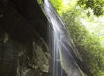
Swim at Sliding Rock Waterfall, North Carolina
Sliding Rock is a waterfall in Western North Carolina, located near Brevard on Looking Glass Creek, in the Pisgah National Forest. It's named because visitors can slide all the way down the waterfall into the plunge pool below. The rock has long been used as a natural water slide for adventurous tourists and locals. The water is very cold and is popular for cooling of... -
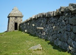
Summit Slieve Commedagh, Northern Ireland
Slieve Commedagh is a mountain with a height of 767 m (2,516 ft) in County Down, Northern Ireland. It is the second-highest of the Mourne Mountains, after Slieve Donard, and the second-highest mountain in Northern Ireland. Slieve Commedagh lies to the northwest of Slieve Donard, and the two are linked by a col. The Mourne Wall passes east-west over the mountaintop, an... -
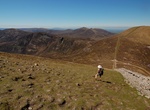
Summit Slieve Donard, Northern Ireland
Slieve Donard is an 850-metre (2,790 ft) mountain in County Down, Northern Ireland. Part of the Mourne Mountains, it is the highest peak in Northern Ireland and in the wider province of Ulster. It is also the 19th highest peak on the island of Ireland. Slieve Donard sits near the town of Newcastle on the eastern coast of County Down, only 2 miles (3 km) from the Irish... -
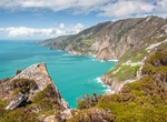
Explore Slieve League, Ireland
Slieve League, is a mountain on the Atlantic coast of County Donegal, Ireland. At 601 metres (1,972 ft), it has some of the highest sea cliffs on the island of Ireland. Although less famous than the Cliffs of Moher in County Clare, Slieve League's cliffs reach almost three times higher. The Belfast naturalist Robert Lloyd Praeger wrote in 1939: A tall mountain of... -
Summit Slioch, Scotland
Slioch is a mountain in the Scottish Highlands situated in Wester Ross, eight kilometres north of the village of Kinlochewe. Slioch reaches a height of 981 metres (3218 feet) and towers above the south east end of Loch Maree to give one of the best known and most photographed sights (from the A832 road) in the Highlands. VisitScotland, the Scottish national tourist ag... -
Visit Słodowa Island, Wrocław, Poland
Słodowa Island (Malt Island) is a small islet on the Oder River within the Wrocław Old Town. Słodowa Island used to be called Bielarska Przednia until 1945. Originally the name came from bleaching linen for the Order of Saint Clare. The island was owned by the Order of Saint Claire from Middle Ages until the beginning of 18th century, when it became the property ... -
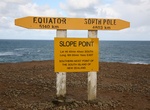
Visit Slope Point, New Zealand
Slope Point is the southernmost point of the South Island of New Zealand. Slope Point lies just south of the small settlements of Waikawa and Haldane, near the southwestern edge of the Catlins and Toetoes Bay and 70 km (40 mi) east of Invercargill. The land around Slope Point is used for sheep farming with no houses anywhere nearby. Eroded cliffs drop down to the sea ... -
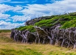
See Slope Point Trees, New Zealand
At the southernmost tip on New Zealand's South Island the extreme winds that batter Slope Point are so strong and consistent that the trees that grow there are molded into strangely and beautifully twisted forms.


Price: $772.57