Give us feedback!


 See all

Our philosophy is simple. We want to encourage you to dream. BIG! Then we help you plan your trip, get the most out of it while you're traveling and help you share your experience with friends.
Join Now It's FREE
Dream Packages
Duration: 2 hours
Price: $604.48
Price: $604.48
Duration: 6 hours
Price: $137.68
Price: $137.68
Duration: 2 days
Price: $340.00
Price: $340.00
Duration: 12 hours
Price: $120.00
Price: $120.00
Related Categories
Dreams Still To Do
Checked-Off Dreams
Dreams Still To Do
Checked-Off Dreams
Advertisement
Explore Natural Wonders
-
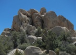
Climb through The Chasm of Doom, Joshua Tree National Park, California
The Chasm of Doom is more of a tight secret passage than a large open chasm that traverses through a large mountain of boulders in the Hidden Valley area. This place is NOT for the faint of heart or the claustrophobic. Not only you’ll need to be comfortable and able to fit in tight spaces, but you will also need to be able to climb, scramble, and boulder in the ... -
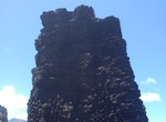
See The Chimney, Saint Helena Island
"The Chimney" is a basalt sea stack near Lot's Wife's Ponds near Sandy Bay. -
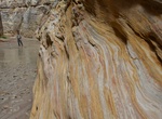
Hike The Chute at Muddy Creek, Utah
Muddy Creek is a stream which drains portions of Emery and Wayne Counties in central Utah, in the western United States. It begins on the eastern slopes of the Wasatch Plateau at elevations above 10,500 feet (3200 m). It turns southward near the town of Emery, then southeastward where it crosses under Interstate 70. It then directly enters the western flank of the San... -
Visit The Cloisters Museum, Fort Tryon Park, Washington Heights, New York City
The Cloisters is a museum located in Fort Tryon Park, Washington Heights, New York City. The building, which is a branch of the Metropolitan Museum of Art, was built in the 1930s resembling architectural elements of several European medieval abbeys. It is used to exhibit art and architecture from Medieval Europe. The Cloisters, which is near the northern tip of Manhat... -
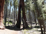
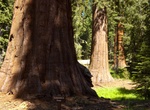
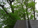
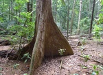
See The Clothespin Tree, Mariposa Grove, Yosemite National Park, California
Countless fires throughout the decades nearly severed this tree's trunk of The Clothespin tree, creating a space in it large enough for a pick-up truck to drive through. -
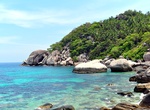
Hike The Coast from Mae Haad to Chalok, Ko Tao, Thailand
This hike is easy and goes from south-west part of the island to the south. You will visit 7 beaches located close to each other. Bring enough water with you and a hat. -
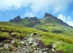
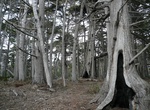
Summit The Cobbler, Scotland
The Cobbler is a mountain of 884 metres (2,900 ft) height located near the head of Loch Long in Scotland. Although only a Corbett, it is "one of the most impressive summits in the Southern Highlands", and is also the most important site for rock climbing in the Southern Highlands. Many maps include the name Ben Arthur (an anglicisation of the Gaelic), but the nameThe ... -
See The Columbia Tree, Mariposa Grove, Yosemite National Park, California
The Columbia tree is the tallest tree in the grove and in Yosemite National Park at 286 feet (87 m). -
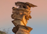
See The Control Tower (Dali Rock), Coyote Buttes South, Arizona
The Control Tower (Dali Rock) is a rock formation in Coyote Buttes South, Arizona. Visit Control Tower just before sunset in late Fall and early Winter for the best photos. The Control Tower is also the closest formation to the parking area. -
Visit The Copse of Trees, Gettysburg National Military Park, Pennsylvania
The copse of trees, currently a prominent landmark, was under ten feet (3 m) high in 1863, only visible to a portion of the attacking columns from certain parts of the battlefield. It was used as the target landmark for Pickett's Charge. -
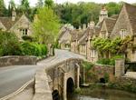
Explore The Cotswolds, England
The Cotswolds are a range of hills in west-central England, sometimes called the "Heart of England", an area 25 miles (40 km) across and 90 miles (145 km) long. The area has been designated as the Cotswold Area of Outstanding Natural Beauty. The highest point in the Cotswolds range is Cleeve Hill at 1,083 ft (330 m), 2.5 miles (4 km) to the north of Cheltenham. The Co... -
Visit The Crocker Cypress Grove, Pebble Beach, California
Crocker Grove is home to the largest and oldest Monterey Cypress trees in existence. It's the 11th stop on the 17-Mile Drive. -
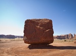
See The Cube, Monument Valley, Arizona
The Cube is a 200-Ton boulder at southern most point of Spearhead Mesa in Monument Valley, Arizona. -
Explore The Dales, Christmas Island, Australia
The Dales comprises of numerous freshwater streams running roughly parallel to each other. The streams originate from underground caves and eventually flows into the ocean. The streams over the length of time, have worn out gullies between the cliff walls of the coast, and have created unusually step-like formations (terraces). There is a waterfall above the terrace f... -
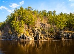
Visit The Dalles of the St. Croix River, Interstate Park, Wisconsin
The Dalles of the St. Croix River features an L-shaped segment of the St. Croix River gorge cut through Precambrian basalt by meltwater drainage from Glacial Lake Duluth. Erosion, frost, and gravity acting on the bedrock have resulted in vertical cliffs, unusual pinnacle forms, and rocky talus slopes. The site is well known for its cylindrical potholes, which were for...

Price: $137.68