Give us feedback!


 See all

Our philosophy is simple. We want to encourage you to dream. BIG! Then we help you plan your trip, get the most out of it while you're traveling and help you share your experience with friends.
Join Now It's FREE
Dream Packages
Duration: 11 hours
Price: $240.19
Price: $240.19
Duration: 14 to 15 hours
Price: $170.10
Price: $170.10
Duration: 6 hours
Price: $137.22
Price: $137.22
Duration: 2 days
Price: $359.00
Price: $359.00
Related Categories
Dreams Still To Do
Checked-Off Dreams
Dreams Still To Do
Checked-Off Dreams
Advertisement
Explore Natural Wonders
-
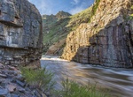
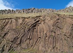
Explore The Narrows at Poudre Canyon, Colorado
The Poudre Canyon is a narrow verdant canyon, approximately 40 mi (64 km) long, on the upper Cache la Poudre River (called the "Poudre" for short, which locals pronounce as "Pooder") in Larimer County, Colorado in the United States. The canyon is a glacier-formed valley through the foothills of the Front Range of the Rocky Mountains northwest of Fort Collins. The cany... -
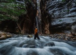
Hike Top-Down through The Narrows (North Fork Virgin River), Zion National Park, Utah
Permits are required for this 16-mile through-hike of the Virgin River Narrows from Chamberlain's Ranch to the Temple of Sinawava. Those who choose this option must arrange their own transportation to the Chamberlain's Ranch trailhead. Estimated Hiking Time is 10 to 14 hours (Can be split into two days with an overnight backpacking permit.)When conditions allow, apply... -
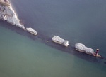
See The Needles, Isle of Wight, England
The Needles is a row of three distinctive stacks of chalk that rise out of the sea off the western extremity of the Isle of Wight, UK, close to Alum Bay. The Needles Lighthouse stands at the outer, western end of the formation. Built in 1859, it has been automated since 1994. The formation takes its name from a fourth needle-shaped pillar called Lot's Wife that collap... -
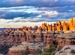
Explore The Needles, Canyonlands National Park, Utah
The Needles forms the southeast corner of Canyonlands and was named for the colorful spires of Cedar Mesa Sandstone that dominate the area. Hiking trails offer many opportunities for long day hikes and overnight trips. Foot trails and four-wheel-drive roads lead to such features as Tower Ruin, Confluence Overlook, Elephant Hill, the Joint Trail, and Chesler Park. Dire... -
Hike The Oasis of Mara, Joshua Tree, California
Visitor center with educational exhibits, a water station & gift shop, plus picnic tables & a trail. The oasis was first settled by the Serrano who called it Mara, meaning "the place of little springs and much grass." Legend holds they came to the oasis because a medicine man told them it was a good place to live and that they would have many boy babies. The ... -
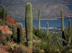
Explore Theodore Roosevelt Lake, Arizona
Theodore Roosevelt Lake (usually called Roosevelt Lake, sometimes Lake Roosevelt) is a large reservoir formed by Theodore Roosevelt Dam on the Salt River in Arizona as part of the Salt River Project (SRP). Located roughly 80 miles (130 km) northeast of Phoenix in the Salt River Valley, Theodore Roosevelt is the largest lake or reservoir located entirely within the sta... -
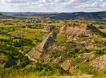
Explore Theodore Roosevelt National Park, North Dakota
Theodore Roosevelt National Park in the US comprising three geographically separated areas of badlands in western North Dakota. Both main units of the park have scenic drives, approximately 100 miles of foot and horse trails, wildlife viewing, and opportunities for back country hiking and camping. There are three developed campgrounds: Juniper Campground in the North ... -
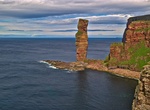
Hike to The Old Man of Hoy, Scotland
A 450-foot sea stack that visitors can walk to from Rackwick, but the walk can be a bit demanding in some parts. Rock climbers have climbed the Old Man. There is some concern that the Old Man of Hoy may not stand much longer, so see it sooner rather than later. -
See The Old Women Columnar Basalt, Hov, Suduroy, Faroe Islands
These basalt formations are just next to the road to the north of Hov, Suduroy, Faroe Islands. -
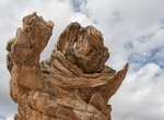
See The Olympic Torch, Coyote Buttes South, Arizona
The Olympic Torch is a rock formation in Coyote Buttes South, Arizona. -
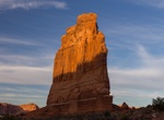
See The Organ, Arches National Park
The Organ is an impressive sandstone tower in Arches National Park. -
Explore The Outback, Australia
The Outback is the vast, remote, arid interior of Australia. The term "the outback" is generally used to refer to locations that are comparatively more remote than those areas named "the bush" which, colloquially, can refer to any lands outside the main urban areas. Other than agriculture and tourism, the main economic activity in this vast and sparsely settled area i... -
Explore the Ozarks, USA
The Ozarks, also referred to as the Ozark Mountains and Ozark Plateau, is a physiographic region in the U.S. states of Arkansas, Missouri, Oklahoma, and Kansas. The Ozarks cover a significant portion of northern Arkansas and southern Missouri, extending from Interstate 40 in Arkansas to the suburbs of St. Louis. A portion of the Ozarks extends into northeastern Oklaho... -
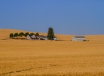
Explore The Palouse, Idaho
The Palouse is a distinct geographic region of the northwestern United States, encompassing parts of north central Idaho, southeastern Washington, and, by some definitions, parts of northeast Oregon. It is a major agricultural area, primarily producing wheat and legumes. Situated about 160 miles (260 km) north of the Oregon Trail, the region experienced rapid growth i... -
Explore The Panhandle, San Francisco, California
The Panhandle is a park in San Francisco, California that forms a panhandle with Golden Gate Park. It is long and narrow, being three-quarters of a mile long and one block wide. Fell Street borders it to the north, Oak Street to the south, and Baker Street to the east. Only two streets run through it, Stanyan Street at the western end between it and Golden Gate Park, ...


Price: $772.57