Give us feedback!


 See all

Our philosophy is simple. We want to encourage you to dream. BIG! Then we help you plan your trip, get the most out of it while you're traveling and help you share your experience with friends.
Join Now It's FREE
Dream Packages
Duration: 6 hours
Price: $137.68
Price: $137.68
Duration: 3 days
Price: $618.62
Price: $618.62
Duration: 12 hours 30 minutes
Price: $164.45
Price: $164.45
Duration: 10 hours
Price: $249.99
Price: $249.99
Related Categories
Dreams Still To Do
Checked-Off Dreams
Dreams Still To Do
Checked-Off Dreams
Advertisement
Explore Unusual Wonders of Nature
-
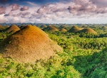
Explore Chocolate Hills, Philippines
The Chocolate Hills is an unusual geological formation in Bohol province, Philippines. The Chocolate Hills is a famous tourist attraction of Bohol. They are featured in the provincial flag and seal to symbolize the abundance of natural attractions in the province. They are in the Philippine Tourism Authority's list of tourist destinations in the Philippines; they have... -
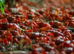
See Christmas Island Red Crab Migration
The annual Red Crab Migration on Christmas Island sees upwards of 100 million of these unique land crabs making a formidable trip from their inland habitat to the sea in order to procreate. Their annual trek to the sea begins 9 – 18 days before the animals spawn and usually occurs around Christmas each year but can be as early as October, depending on the phases... -
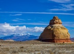
See Church Rock, Utah
Church Rock is a solitary column of sandstone in southern Utah along the eastern side of U.S. Route 191, near the entrance to the Needles District of Canyonlands National Park. With majestic Colorado and Green River canyons, Canyonlands, this 200 foot roadside oddity near Monticello is called Church Rock. It seldom attracts more than a casual glance as visitors h... -
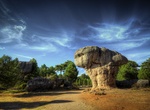
Visit Ciudad Encantada (Enchanted City), Castilla-La Mancha, Spain
The Ciudad Encantada (Enchanted City) is a geological site near the city of Cuenca, in the autonomous community of Castilla-La Mancha, Spain in which the erosive forces of weather and the waters of the nearby Júcar river have formed rocks into distinctive and memorable shapes. It was declared a Natural Site of National Interest on 11 June 1929. The rock formati... -
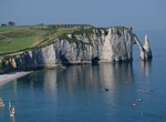
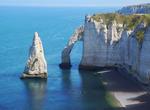
See Cliffs of Étretat, France
Étretat is a tourist and farming town situated c. 32 km northeast of Le Havre, at the junction of the D940, D11 and D139 roads. It's located on the coast of the Pays de Caux area. Étretat is best known for its cliffs, including 3 natural arches and the pointed "needle". These cliffs and the associated resort beach attracted artists including Eugèn... -
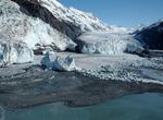
Visit College Fjord, Prince William Sound, Alaska
College Fjord is a fjord located in the northern sector of Prince William Sound in the U.S. state of Alaska. The fjord contains five tidewater glaciers (glaciers that terminate in water), five large valley glaciers, and dozens of smaller glaciers, most named after renowned East Coast colleges (women's colleges for the NW side, and men's colleges for the SE side). Coll... -
Explore Comb Ridge Area, Bears Ears National Monument, Utah
NOTE: Day hiking in the Comb Ridge area of Bears Ears National Monument requires a day hiking pass. Day hiking passes are unlimited. Comb Ridge is located in the southern portion of Bears Ears National Monument. Backpackers and day hikers alike enjoy rugged routes through the deep gorges of Grand Gulch and the many canyons within Comb Ridge. Visitors may stop by Kane... -
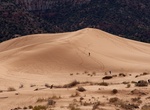
Explore Coral Pink Sand Dunes State Park, Utah
Coral Pink Sand Dunes State Park is a state park of Utah, USA, located between Mount Carmel Junction and Kanab, south and west of U.S. Highway 89 in southwestern Utah. The park features coral-hued sand dunes located beside red sandstone cliffs. The Dunes are formed from the erosion of pink-colored Navajo Sandstone surrounding the park. High winds passing through the n... -
See Côte d'Albâtre, Le Tilleul, France
The Côte d'Albâtre (Alabaster Coast) is part of the French coast of the English Channel. It derives its name from its white cliffs, which stretch over 120 km, forming a unique landscape in the world. High vertical walls of limestone rising from 60 to 120 m above sea level, the cliffs are, in places, streaky veins of black flint. Attack the sea, and thus g... -
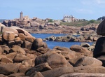
Explore Côte de Granit Rose (Pink Granite Coast), Brittany, France
The Côte de granit rose or Pink Granite Coast is a stretch of coastline in the Côtes d'Armor departement of northern Brittany, France. It stretches for more than thirty kilometres from Plestin-les-Grèves to Louannec, encompassing Trégastel. It has become a popular tourist destination due to its unusual pink sands and rock formations. This typ... -
Explore Cowichan River Provincial Park, Vancouver Island, British Columbia, Canada
Cowichan River Provincial Park is a provincial park on Vancouver Island in British Columbia, Canada. It includes the Cowichan River in a 750-hectare area stretching almost 20 kilometres, from the village of Lake Cowichan to Glenora, just south of Duncan. Its paths are part of the Trans Canada Trail. -
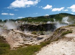
Explore Craters of the Moon, New Zealand
Craters of the Moon Thermal Area is a region with geothermal activity north of Taupo, New Zealand. It is a part of Wairakei, the largest geothermal field in New Zealand, with a surface area of about 25 km2, which lies in the Taupo Volcanic Zone. The name springs from the many hydrothermal eruption craters, which are in part barren and which have bright colours. Combin... -
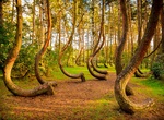
Visit Crooked Forest, Poland
The Crooked Forest is a grove of oddly-shaped pine trees located outside Nowe Czarnowo, West Pomerania, Poland. This grove of approximately 400 pines was planted around 1930, when its location was still within the German province of Pomerania. It is generally believed that some form of human tool or technique was used to make the trees grow this way, but the method an... -
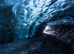
See Crystal Cave in Svínafellsjökull Glacier, Iceland
The Crystal Cave located in Svínafellsjökull glacier in Vatnajökull National Park emerged as a result of its glacier meeting the Icelandic coastline where the preasure has compressed all air out of the ice adding to the texture and colour of the cave. The cave is located in the Skaftafell preservation area that is part of Vatnajökull National Par... -
Off-road to Crystal Geyser, Utah
Crystal Geyser is located on the east bank of the Green River approximately 4.8 miles downstream from Green River, Utah. It is a rare example of a cold water carbon dioxide driven geyser; geothermal activity does not play a role in the activity of the geyser. The ground water near the geyser has significant quantities of dissolved carbon dioxide, along with substantia...

Price: $133.63