Give us feedback!

Our philosophy is simple. We want to encourage you to dream. BIG! Then we help you plan your trip, get the most out of it while you're traveling and help you share your experience with friends.
Join Now It's FREE
Dreams Still To Do
Checked-Off Dreams
Dreams Still To Do
Checked-Off Dreams
Advertisement
Explore Outdoors
-
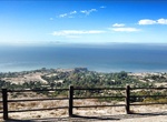
Hike Del Cerro Park, Rancho Palos Verdes, Los Angeles County, California
Del Cerro Park is a public park located in Rancho Palos Verdes, Los Angeles County, California. The park is situated high atop a bluff at the southernmost end of Crenshaw Boulevard. Del Cerro Park is noted for its sweeping views of the Pacific Ocean and Catalina Island. Tremendous hiking with great ocean views. Starts as downhill so prepared for the uphill on the retu... -
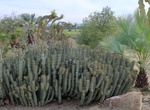
Visit Desert Garden, Balboa Park, San Diego, California
The Desert Garden contains more than 1,300 plants, including succulents and drought-resistant plants from around the world, within its 2.5 acres. The peak blooming period is January through March; however, these plants are interesting at any time of year because of their unusual shapes. North of the Park Boulevard Pedestrian Bridge near the Inez Grant Parker Memorial ... -
Visit Desert View Tower & In-Ko-Pah Boulder Park, California
The Desert View Tower is located on Interstate 8, near Jacumba and Ocotillo, in western Imperial County, Southern California. It is at 3,000 feet (910 m) in elevation, in the In-Ko-Pah Mountains. The stone tower was built from 1922 to 1928 as a roadside attraction by Bert Vaughn, a real estate developer who owned Jacumba. The three story tower houses a museum and has ... -
Hike Devastation Trail, Hawaii Volcanoes National Park, Hawaii
Devastation Trail is a trail at Hawaiʻi Volcanoes National Park. The trail, which is paved, allows visitors to explore the site of 1959 eruption of Kīlauea Iki crater. Before the 1959 eruption of Kīlauea Iki, the area that is now designated Devastation Trail was covered by a dense rain forest. Devastation Trail is located off Chain of Craters Road in Hawaiʻi Volcanoes... -
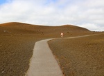
Explore Devil's Punchbowl, California
Devil's Punchbowl, elevation 4,750 ft (1450 m), is a tilted sandstone formation in Los Angeles County. It is a county park within the Angeles National Forest on the northern slopes of the San Gabriel Mountains, near Littlerock, California. Short trails within the park showcase the geologic features along the Punchbowl and San Andreas Faults. There are connections to m... -
Visit Dewey Square Park, Boston, Massachusetts
Dewey Square Park in Boston, Massachusetts is located between Congress and Summer Streets along Atlantic Avenue. Dewey Square Park joins the major transportation hub of South Station to the Financial District. The park has gardens, lawn areas, and the adjacent plaza, which was designed to draw in commuters and nearby workers and residents. The tables, chairs, and food... -
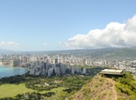
Hike Diamond Head Crater, Oahu Hawaii
Hike to the top of Diamond Head crater, one of the most iconic sites on Oahu. A 0.75-mile (1.1-km) hike leads to the edge of the crater's rim and should take 1½-2 hours. The trail was built in 1908 and was initally used by the military to defend Oahu from invaders. Today hikers climb it to see some of the most spectacular views of the island. Although not diffi... -
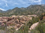
Explore Dinosaur Valley State Park, Texas
Dinosaur Valley State Park is a state park in Texas near Glen Rose, Texas. Dinosaur Valley State Park, located just northwest of Glen Rose in Somervell County, is a 1,524.72-acre (617 ha) scenic park set astride the Paluxy River. The land for the park was acquired from private owners under the State Parks Bonds Program during 1968 and opened to the public in 1972. In ... -
Play Disc Golf at Morley Field, San Diego, California
Morley Field was established by Snapper Pierson (course pro and Disc Golf Hall of Fame member) in 1978 making one of the original disc golf courses in the world. The field is directly across from the San Diego Zoo, this makes Morley a destination course with a personality all its own. The course overall isn’t long but it does have a few lengthy holes and it&lsq... -
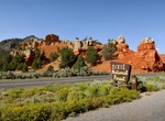
Explore Dixie National Forest, Utah
Dixie National Forest is a United States National Forest in Utah with headquarters in Cedar City. It occupies almost two million acres (8,000 km²) and stretches for about 170 miles (270 km) across southern Utah. The largest national forest in Utah, it straddles the divide between the Great Basin and the Colorado River. In descending order of forestland area it is... -
Canoe or Kayak Dolan Center Launch to Town Landing Lane, Massachusetts
Canoe or kayak along the Dedham Water Trail near Boston, Massachusetts. Dolan Launch to Town Landing is about 1.8 miles long and located in Dedham, Massachusetts. The route takes 1 hour or less. -
Spot Domestic Pigeon (Columba livia)
Rock Pigeons come in many different shades, colors and patterns, with the “blue-bar” form, a bluish-gray bird with two black bands on the wing and, a black tip to the tail, being considered the most recognized form. Diet and behavioral habits: Introduced to Balboa Park at the 1915 Panama-California Exposition, to create an environment similar to European ... -
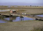
Birding at Don Edwards San Francisco Bay National Wildlife Refuge, California
Don Edwards San Francisco Bay National Wildlife Refuge is located in the southern part of San Francisco Bay, California. Most of the refuge stretches along the marshy shoreline north and south of the Dumbarton Bridge, but Bair Island, in San Mateo County, is also part of the system. The southernmost extent of the refuge is in northern Santa Clara County. It was founde... -
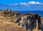
Hike to Dragon’s Teeth (Makaluapuna Point), Maui, Hawaii
Dragon’s Teeth is an unique rock formation on Maui’s Makaluapuna Point. It was created during the island’s last lava flows. As the lava flowed, fierce winds and waves swept the flow upward until it hardened into what looks like jagged teeth. It's side by side with the golf course of Ritz Carlton. It's a short walk from the parking lot (if space is a... -
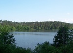
Explore Drawa National Park, Poland
Drawa National Park (Drawieński Park Narodowy) is located in north-western Poland, on the border of Greater Poland, Lubusz and West Pomeranian Voivodeships. The park is a part of the huge Drawsko Forest (Puszcza Drawska), which lies on the vast Drawsko Plain. It takes its name from the River Drawa. It was created in 1990 and initially covered 86.91 km². Later, it...