Give us feedback!

Our philosophy is simple. We want to encourage you to dream. BIG! Then we help you plan your trip, get the most out of it while you're traveling and help you share your experience with friends.
Join Now It's FREE
Dreams Still To Do
Checked-Off Dreams
Dreams Still To Do
Checked-Off Dreams
Advertisement
Explore Outdoors
-
Explore The Panhandle, San Francisco, California
The Panhandle is a park in San Francisco, California that forms a panhandle with Golden Gate Park. It is long and narrow, being three-quarters of a mile long and one block wide. Fell Street borders it to the north, Oak Street to the south, and Baker Street to the east. Only two streets run through it, Stanyan Street at the western end between it and Golden Gate Park, ... -
Explore The Quiraing, Isle of Skye, Scotland
The Quiraing is a landslip on the eastern face of Meall na Suiramach, the northernmost summit of the Trotternish on the Isle of Skye, Scotland. The whole of the Trotternish Ridge escarpment was formed by a great series of landslips; the Quiraing is the only part of the slip still moving, the road at its base, near Flodigarry, requires repairs each year. Parts of the d... -
Hike The Storr & Old Man of Storr, Isle of Skye, Scotland
The Storr is a rocky hill on the Trotternish peninsula of the Isle of Skye in Scotland. The hill presents a steep rocky eastern face overlooking the Sound of Raasay, contrasting with gentler grassy slopes to the west. A well constructed path, used by many sightseers, leaves the A855 just north of Loch Leathan. It heads up through an area formerly covered by evergreens... -
See The Victims, Merrion Square, Dublin, Ireland
The Victims is a sculpture group of three figures: a dead soldier strapped to a bier, mourned by his wife and his mother -
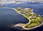
Explore Thompson Island, Massachusetts
Thompson Island is an island in the Boston Harbor, some 2 miles offshore from downtown Boston, Massachusetts. The island is managed by the Thompson Island Outward Bound Education Center, a non-profit education organization. The island is open to visitors on Saturdays and Sundays from Memorial Day through Labor Day; otherwise access is by arrangement only. Thompson Isl... -
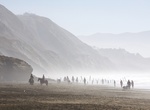
Visit Thornton State Beach, California
Thornton State Beach is a protected beach in the state park system of California, USA, but is officially closed to the public. It is located on the Pacific coast of Daly City in the San Francisco Bay Area. The park was closed due to damage and continued danger from landslides, though locals still access the site for hiking, horseback riding, and beach activities.... -
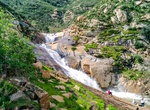
Hike Three Sisters Falls, Julian, California
The hike to Three Sisters Falls in Julian, California was not for beginners due to the steep inclines/declines, rock/boulder climbing, and sun exposure. Gaining in popularity, this often crowded, yet challenging hike takes hikers through several ecosystems before leading to the main event - three large waterfalls wedged between tall, rocky mountains. Having recently u... -
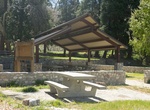
Visit Thurman Flats Picnic Area, Mill Creek, California
This picnic area is on Highway 38, about 3.5 miles northeast of the Mill Creek Ranger Station. This is one of the best bird watching areas on the Forest, with over 200 species seen here. Look in the incense cedars at the picnic area and in the alders growing along the creek: yellow warblers, and Lawrence’s goldfinch, scrub jays, hooded orioles, and northern orio... -
Explore Tidal Basin, Washington, D.C.
The Tidal Basin is a partially man-made reservoir between the Potomac River and the Washington Channel in Washington, D.C. It is part of West Potomac Park and is a focal point of the National Cherry Blossom Festival held each spring. The Jefferson Memorial, the Martin Luther King, Jr. National Memorial, the Franklin Delano Roosevelt Memorial, and the George Mason Memo... -
Ride Tidal Basin Boat House, Washington, DC
Get ready to paddle your way around the Tidal Basin and spend some time with Thomas Jefferson! Soak up the sun and make monumental memories on the water in a swan boat or paddle boat. Visit in March and April to experience thousands of cherry trees in full bloom, and fill your summer days with leisurely peddling, picturesque views, and picnics in the park. -
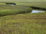
Explore Tijuana River Estuary, San Diego, California
The Tijuana River Estuary is an intertidal coastal wetland at the mouth of the Tijuana River in San Diego County, California, in the United States bordering Tijuana, Baja California, Mexico. It is the location of the Tijuana River National Estuarine Research Reserve, Tijuana Slough National Wildlife Refuge, and Border Field State Park. The estuary is a shallow water h... -
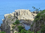
Explore Tōjinbō Cliffs, Japan
Tōjinbō is a series of cliffs on the Sea of Japan in Japan. It is located in the Antō part of Mikuni-chō in Sakai, Fukui Prefecture. The cliffs average 30 metres (98 ft) in height and stretch for 1 km (3,281 ft). The area is part of the Echizen-Kaga Kaigan Quasi-National Park. The cliffs' rocks were originally formed 12 to 13 million years ago during the Miocene Epoch... -
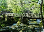
Explore Tolleymore Forest Park, Newcastle, Ireland
Tollymore Forest Park was the first state forest park in Northern Ireland, established on 2 June 1955. It is located at Bryansford, near the town of Newcastle in the Mourne and Slieve Croob Area of Outstanding Natural Beauty. It covers an area of 630 hectares (1,600 acres) at the foot of the Mourne Mountains and has views of the surrounding mountains and the sea at ne... -
Visit Tompkins Square Park (East Village), Manhattan, New York City
Tompkins Square Park is a 10.5-acre (4.2 ha) public park in the Alphabet City portion of East Village, Manhattan, New York City. United States. The square-shaped park, bounded on the north by East 10th Street, on the east by Avenue B, on the south by East 7th Street, and on the west by Avenue A, is abutted by St. Marks Place to the west. Increasing gentrification in t... -
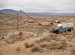
Visit Tonopah Historic Mining Park, Nevada
The Tonopah Historic Mining Park is on the site of Belle and Jim Butler's original mining claim which started the rush to Tonopah making it the "Queen of the Silver Camps." Great area for mountain biking and hiking too. Admission: Visitors Center: Free Walking Tour: Adults $5.00Seniors $4.00Students (8-17) $3.00Children (7 & under) FreeVeterans/Military Free ...