Give us feedback!


 See all

Our philosophy is simple. We want to encourage you to dream. BIG! Then we help you plan your trip, get the most out of it while you're traveling and help you share your experience with friends.
Join Now It's FREE
Dream Packages
Duration: 11 days
Price: $1534.00
Price: $1534.00
Duration: 2 days
Price: $359.00
Price: $359.00
Duration: 12 hours
Price: $224.21
Price: $224.21
Duration: 5 days
Price: $726.42
Price: $726.42
Related Categories
- 1-on-1 with Animals
- Australian National Parks & Reserves
- Canadian National Parks
- Fjords
- Glaciers
- Hikes & Treks
- New Zealand National Parks
- Outdoors in Utah
- Parks
- Safari Destinations
- Slot Canyons
- South African National Parks
- UK National Parks
- UNESCO Parks & Preserves
- US National Parks
- US NPS Units
- US State Parks
Dreams Still To Do
Checked-Off Dreams
Dreams Still To Do
Checked-Off Dreams
Advertisement
Explore Parks & Reserves
-
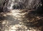
Explore Temescal Canyon Park, California
Temescal Gateway Park located at 15601 Sunset Blvd., is one of the most popular parks in the Santa Monica Mountains. The park encompasses 141 acres of oak and sycamore canyons, ridgetop views, and access to miles of trails in Topanga State Park, Will Rogers State Historic Park, and the 20,000-acre “Big Wild.” -
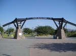
Explore Tempe Beach Park, Tempe, Arizona
Local landmark features a splash playground, boating, a baseball diamond & other athletic fields. -
Explore Ténéré, Niger & Chad (UNESCO site)
The Ténéré is a desert region in the south central Sahara. It comprises a vast plain of sand stretching from northeastern Niger into western Chad, occupying an area of over 154,440 square miles (400,000 km2). Its boundaries are said to be the Aïr Mountains in the west, the Hoggar Mountains in the north, the Djado Plateau in the northeast, the... -
Explore Tennessee National Wildlife Refuge
Tennessee National Wildlife Refuge is a National Wildlife Refuge established in 1945 and located along the shores of the Tennessee River in West Tennessee where the empoundment of Kentucky Lake by the Tennessee Valley Authority has created a more-or-less permanent wetlands environment favored by many species of waterfowl. The entire refuge area is 51,359.46 acres (207... -
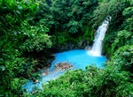
Explore Tenorio Volcano National Park, Costa Rica
Tenorio Volcano National Park (Parque Nacional Volcán Tenorio) is a National Park in the northern part of Costa Rica, which forms part of the Arenal Tilaran Conservation Area. The jewel of the National Park is the volcano, from which it receives its name. The Tenorio Volcano was made part of the National Park in 1995 and is located about 26 miles northeast from... -
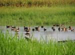
Birding at Tensas River National Wildlife Refuge, Louisiana
The Tensas River National Wildlife Refuge is located in the upper basin of the Tensas River in northeast Louisiana which was the last documented home of the ivory-billed woodpecker. Concentrations of ducks, geese, raptors, wading birds and shorebirds are present. Several rookeries are in the reserve. The refuge is home to one of the last concentrations of the threaten... -
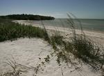
Explore Ten Thousand Islands National Wildlife Refuge, Florida
The Ten Thousand Islands are a chain of islands and mangrove islets off the coast of southwest Florida, between Cape Romano (at the southern end of Marco Island) and the mouth of Lostman's River. Some of the islands are high spots on a drowned shoreline. Others were produced by mangroves growing on oyster bars. Despite the name, the islets in the chain only number in ... -
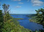
Explore Terra Nova National Park, Newfoundland, Canada
Terra Nova National Park is located on the east coast of Newfoundland in the Canadian province of Newfoundland and Labrador, along several inlets of Bonavista Bay. The park takes its name from the Latin name for Newfoundland. Terra Nova's landscape is typical of the northeast coast of Newfoundland, with remnants of the Appalachian Mountains contributing to widely vari... -
Explore Terra Ronca State Park, São Domingos, Brazil
The Terra Ronca State Park was created by decree nr. 10,879 of 7 July 1989 and had its area and boundaries established by decree nr. 4,700 of 21 August 1996, covering the municipality of São Domingos. Around the state park they created the environmental protection area (APA) of the Serra Geral, by decree nr. 4,666 of 16 April 1996. The areas of these two protec... -
Visit Terrazza Riccardo Marasco, Florence, Italy
Terrazza Riccardo Marasco is a small park overlooking the river in Florence, Italy. -
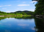
Birding at Tetlin National Wildlife Refuge, Alaska
Tetlin National Wildlife Refuge is a dynamic landscape made up of forests, wetlands, tundra, lakes, mountains and glacial rivers bounded by the snowy peaks of the Alaska Range. This upper Tanana River valley has been called the "Tetlin Passage," because it serves as a major migratory route for birds traveling to and from Canada, the lower 48 and both Central and South... -
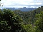
Explore Te Urewera National Park, New Zealand
Te Urewera National Park is one of fourteen national parks within New Zealand and is the largest of the four in the North Island. Covering an area of approximately 2,127 km², it is in the north east of the Hawke's Bay region of the North Island. On 28 July 1954, the catchment areas of Lake Waikaremoana, Lake Waikareiti and other Crown reserves were gazetted as a ... -
Walk around Texas Capitol Grounds, Austin, Texas
The Capitol building is surrounded by 22 acres (8.9 ha) of grounds scattered with statues and monuments. William Munro Johnson, civil engineer, was hired in 1888 to improve the appearance of the grounds. By the time the first monument, commemorating the Heroes of the Alamo, was installed in 1891, the major components of Johnson's plan were in place. These included a "... -
Explore Texas Hill Country, Texas
The Texas Hill Country is a geographic region located in the Edwards Plateau at the crossroads of West Texas, Central Texas, and South Texas. Given its location, climate, terrain, and vegetation, the Hill Country can be considered the border between the American Southwest and Southeast. The region is notable for its karst topography and tall rugged hills of limestone ... -
Explore Thai Prachan National Park, Yang Hak, Thailand
Scenic wildlife-filled national park with tranquil trails for biking & hiking, plus camping areas.


Price: $240.61