Give us feedback!

Our philosophy is simple. We want to encourage you to dream. BIG! Then we help you plan your trip, get the most out of it while you're traveling and help you share your experience with friends.
Join Now It's FREE
Related Categories
- Arizona State Parks
- Australian National Parks & Reserves
- Canada Provincial Parks
- Canadian National Parks
- New Zealand National Parks
- Parks & Reserves
- South African National Parks
- UK National Parks
- UNESCO Parks & Preserves
- US Historical Parks (NHP)
- US National Parks
- US Parks & Landmarks
- US State Parks
Dreams Still To Do
Checked-Off Dreams
Dreams Still To Do
Checked-Off Dreams
Advertisement
Explore Parks
-
Visit Agate Fossil Beds Visitor Center and Museum, Harrison, Nebraska
The visitor center offers a life-size diorama of the ancient landscape, and other informative interactive exhibits. -
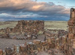
Hike to Agate House Pueblo, Petrified Forest National Park, Arizona
Agate House is a partially reconstructed Puebloan building in Petrified Forest National Park, built almost entirely of petrified wood. The eight-room pueblo has been dated to approximately the year 900 and occupied through 1200, of the Pueblo II and Pueblo III periods. The agatized wood was laid in a clay mortar, in lieu of the more usual sandstone-and-mortar masonry ... -
Explore Ag-Gel National Park, Azerbaijan
Ag-Gel National Park is a national park of Azerbaijan. It was established by the decree of the President of Azerbaijan Ilham Aliyev, in an area in Ağcabədi Rayon and Beyləqan Rayon administrative districts on July 5, 2003 on the basis of the former "Ag-Gol State Reserve" and "Ag-Gol State Game Reserve" which it superseded, on a surface area of 17,924 hectares (179.24 ... -
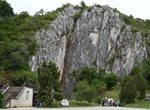
Explore Aggtelek National Park, Hungary
Aggtelek National Park (Aggteleki Nemzeti Park) is a national park in Northern Hungary, in the Aggtelek Karst region. The most significant values of the national park are the special surface formations and caves in this limestone landscape. The park consists of 280 caves with different sizes. It covers a total area of 198.92 km2 of which 39.22 km2 are under increased ... -
Aghaegbulam Uga, MD, El Paso, Texas
Dr. Aghaegbulam H. Uga, MD FACP, FWACP, is a board-certified psychiatrist serving El Paso and Las Cruces who is breaking barriers of mental health. Dr. Uga offers a full range of primary care services, medication-based and non-medication-based treatments, Transcranial Magnetic Stimulation therapy and other medical technology shaping a new age of patient care. In addit... -
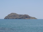
Explore Agioi Theodoroi National Park, Crete
Agioi Theodoroi are two uninhabited islets off the coast of western Crete. One is named Agios Theodoros, also called Thodorou, and the islet a few metres further north is called Mikros Agios Theodoros ("Little Agios Theodoros"). Administratively, they are part of the municipality of Platanias, in Chania regional unit. Kri-kri inhabit Agios Theodoros. Anciently, the is... -
Camp at Agua Caliente County Park, California
Agua Caliente County Park is a 910 acres (370 ha; 1.42 sq mi) park with geothermally heated springs. The park is located just west of Anza-Borrego Desert State Park, in eastern San Diego County, California. Agua Caliente is located about 110 miles (180 km) east of downtown San Diego. Spring water feed pools include an outdoor swimming pool, an outdoor wading pool for ... -
Visit Agua Canyon Viewpoint, Bryce Canyon National Park, Utah
At Agua Canyon two prominent hoodoos command attention. On the left, is the taller of the two towers, "The Hunter." To the right is a hoodoo commonly referred to as the "Rabbit" or alternatively the "Backpacker." In the early years of Bryce Canyon National Park a great effort was made to name many of the more prominent hoodoos. Over the years many of these have fallen... -
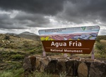
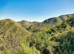
Visit Agua Fria National Monument, Arizona
Agua Fria National Monument is located in the U.S. state of Arizona, approximately 40 miles north of downtown Phoenix, Arizona. Created by Presidential proclamation on January 11, 2000, the 70,900-acre monument is managed by the Bureau of Land Management, an agency within the U.S. Department of the Interior. The Bureau of Land Management already managed the lands; how... -
Visit Águas Quentes State Park, Mato Grosso, Brazil
Quentes State Park is a state park in the state of Mato Grosso, Brazil. The Águas Quentes State Park is in the Guimarães plateau in the Paraguay River depression. The park's vegetation is mainly cerrado, including savanna/seasonal forest, savanna with open trees, riverine forest and seasonal submontane forest. As of 2005 the park was 34% deforested, up f... -
Explore Agua Tibia Wilderness, Temecula, California
Agua Tibia Wilderness (ATW) is a 17,961-acre (72.69 km2) protected area in Riverside and San Diego counties, in the U.S. state of California. It is mostly within the Palomar Ranger District of the Cleveland National Forest. The area was originally protected as the Agua Tibia Primitive Area until January 1975 when it was added to the National Wilderness Preservation Sy... -
Off-road to Aguereberry Point, Death Valley National Park, California
Aguereberry Point is a mountain viewpoint in Death Valley National Park. The point's elevation reaches 6,433 ft and is named for Jean Pierre "Pete" Aguereberry, a Basque miner who was born in 1874, emigrated from France in 1890, and lived at and worked the nearby Eureka Mine from 1905 to his death in 1945. From this point on the Panamint Range, one can view the surrou... -
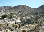
Camp at Aguirre Spring Campground, New Mexico
The high wall, needle-like spires of the Organ Mountains curve dramatically around a semicircle of Chihuahuan Desert habitat at the Aguirre Spring Campground. The campground, nestled at the base of spectacular cliffs, overlooks the Tularosa Basin and White Sands National Monument. Alligator juniper, gray oak, mountain mahogany and sotol are a few of the abundant plant... -
Explore Agulhas National Park, South Africa
The Agulhas National Park is a South African national park located in the Agulhas Plain in the southern Overberg region of the Western Cape, about 200 kilometres (120 mi) south-east of Cape Town. The park stetches along the coastal plain between the towns of Gansbaai and Struisbaai, and includes the southern tip of Africa at Cape Agulhas. The primary tourist attractio... -
Hike and Snorkel ʻĀhihi-Kīnaʻu Natural Area Reserve, Maui, Hawaii
ʻĀhihi-Kīnaʻu Natural Area Reserve includes a coastal lava field and surrounding waters on the southwest coast of the island of Maui, Hawaii. It consists of 1,238 acres on land and 807 acres of ocean along 3 miles (4.8 km) of Maui's southwestern coastline. The reserve includes several popular snorkeling/diving sites and many cultural and geologic sites as well as habi...