Give us feedback!


 See all

Our philosophy is simple. We want to encourage you to dream. BIG! Then we help you plan your trip, get the most out of it while you're traveling and help you share your experience with friends.
Join Now It's FREE
Dream Packages
Duration: 4 hours
Price: $150.91
Price: $150.91
Duration: 25 minutes
Price: $103.02
Price: $103.02
Duration: 3 days
Price: $482.80
Price: $482.80
Duration: 4 hours
Price: $135.27
Price: $135.27
Related Categories
Dreams Still To Do
Checked-Off Dreams
Dreams Still To Do
Checked-Off Dreams
Advertisement
Explore Rivers
-
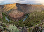
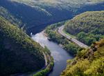
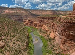
Explore Crooked Wild and Scenic River, Oregon
Lower Crooked Wild and Scenic River, which was designated a Federal Wild and Scenic River in 1988. Located along the Crooked River National Back Country Byway, the 8-mile Chimney Rock segment boast diverse scenery and wildlife and provides access to year-round recreational activities. The area provides for many types of recreation activities including: camping, fishin... -
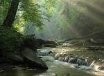
Explore Cuyahoga Valley National Park, Ohio
Cuyahoga Valley National Park preserves and reclaims the rural landscape along the Cuyahoga River between Akron and Cleveland in Northeast Ohio. The 51-square-mile (130 km2) park is the only national park in Ohio. Cuyahoga means "crooked river" in Mohawk. Many visitors spend their time hiking or bicycling the parks' many trails which visit its numerous attractions, in... -
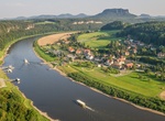
Cruise Danube River, Central and Eastern Europe
The Danube or Donau is Europe's second longest river, after the Volga. It is located in Central and Eastern Europe. The Danube was once a long-standing frontier of the Roman Empire, and today flows through 10 countries, more than any other river in the world. Originating in Germany, the Danube flows southeast for 2,860 km (1,780 mi), passing through or touching the bo... -
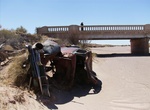
See Dead River, Arizona
Dead River goes under Pinta Rd just a quarter mile west of the old Painted Desert Trading Post in Chambers, Arizona. -
Explore Delaware Water Gap National Recreation Area, New Jersey & Pennsylvania
Delaware Water Gap National Recreation Area, administered by the National Park Service, preserves almost 70,000 acres (28,000 ha) of land along the Delaware River's New Jersey and Pennsylvania shores, stretching from the Delaware Water Gap northward almost to the New York state line. Middle Delaware National Scenic River is a designated 40-mile (64 km) section of the ... -
Explore Delta Wild and Scenic River, Alaska
The Delta River watershed extends from the Upper Tangle Lakes downstream to Black Rapids; the Tangle River flows through and connects the lakes (150,000 acres, 160 miles of streams, and 21 lakes) before finding its way to the Delta River. The Delta then flows north to join the Tanana River and, eventually, the Yukon River. The topography in the vicinity of the lower D... -
Explore Deschutes Wild and Scenic River, Oregon
The Deschutes River is located in central Oregon. It provides much of the drainage on the eastern side of the Cascade Range on its way to its confluence with the Columbia River. The Deschutes was an important resource for thousands of years for Native Americans and in the 19th century for pioneers on the Oregon Trail. The river runs through a deep rimrock-lined canyon... -
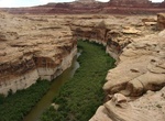
Explore Dirty Devil River, Utah
The Dirty Devil River is an 80-mile-long (130 km) tributary of the Colorado River, located in the U.S. state of Utah. It flows through southern Utah from the confluence of Fremont River and Muddy Creek to the Colorado River. The Dirty Devil River is formed in Wayne County near Hanksville at the confluence of the Fremont River and Muddy Creek. It flows generally south ... -
Explore Dolores River, Colorado
The lower stretch of the Dolores River offers technical rapids, stunning scenery, wildlife viewing, side-canyon hiking, and great camping. A free permit is required. Groups must read and adhere to all stipulations of the permit. Call the Moab Field Office at 435-259-2100 to secure a free permit for floating the Dolores River. Rapids on this section of the Dolores Riv... -
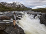
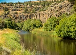
Explore Donner und Blitzen River, Oregon
From its headwaters on Steens Mountain to the Malheur National Wildlife Refuge boundary, the Donner und Blitzen Wild and Scenic River offers breathtakingly beautiful scenic glaciated canyons, unique ecosystems, and exceptional wild trout fisheries. The Donner und Blitzen River, known as the Blitzen River and its tributaries, is located approximately 70 miles south of... -
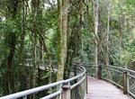
Explore Dorrigo National Park, New South Wales, Australia (UNESCO site)
Dorrigo National Park is a national park in New South Wales (Australia), 580 km north of Sydney on Dome Road off the Waterfall Way, 5 km east of the town of Dorrigo. The Park is part of the New England Group of the World Heritage Site Gondwana Rainforests of Australia inscribed in 1986 and added to the Australian National Heritage List in 2007. This national park is r... -
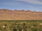
Explore Draa Valley, Morocco
The Draa is Morocco's longest river, at 1,100 kilometres (680 mi). It is formed by the confluence of the Dadès River and Imini River. It flows from the High Atlas mountains, initially south-eastward to Tagounite, and from Tagounite mostly westwards to its mouth in the Atlantic Ocean somewhat north of Tan-Tan. In 1971, the (El) Mansour Eddahabi dam was construct... -
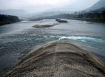
See Dujiangyan Irrigation System, China (UNESCO site)
Dujiangyan is an irrigation infra-structure built in 256 BC during the Warring States Period of China by the Kingdom of Qin. It is located in the Min River in Sichuan province, China, near the capital Chengdu. It is still in use today to irrigate over 5,300 square kilometers of land in the region. The Dujiangyan along with the Zhengguo Canal in Shaanxi Province and th... -
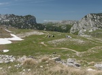
Explore Durmitor National Park, Montenegro (UNESCO site)
Durmitor is a massif and the name of a national park in North Western Montenegro. It reaches a height of 2,522 m (Bobotov Kuk). The massif is bordered by Tara River Canyon on the North, Piva River Canyon on the West, and by Komarnica River Canyon on the South. To the East, Durmitor is open to a vast 1,500 m (4,921 ft) high plateau, called Jezerska Površ (Platea... -
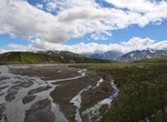
Explore East Fork River, Denali National Park, Alaska
Steep-sided, glacial valleys deep in the Alaska Range define the southern portions of this unit. The East Fork River originates from a large headwater glacier and flows north to the Park Road. Its wide, brush-free gravel river bar is surrounded by open tundra hillsides and small drainages filled with willow. The entire unit is above tree line. The Upper East Fork Riv...
Price: $289.36