Give us feedback!


 See all

Our philosophy is simple. We want to encourage you to dream. BIG! Then we help you plan your trip, get the most out of it while you're traveling and help you share your experience with friends.
Join Now It's FREE
Dream Packages
Duration: 5 hours
Price: $106.33
Price: $106.33
Duration: 4 hours
Price: $120.43
Price: $120.43
Duration: 3 hours 30 minutes
Price: $99.36
Price: $99.36
Duration: 3 hours
Price: $173.83
Price: $173.83
Related Categories
Dreams Still To Do
Checked-Off Dreams
Dreams Still To Do
Checked-Off Dreams
Advertisement
Explore Kayak/Canoe
-
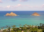
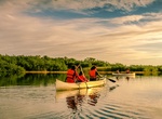
Kayak around Mokes (Na Mokulua), Oahu, Hawaii
Nā Mokulua (meaning, in Hawaiian, "the two islands") are two islets off the windward coast of O‘ahu in the Hawaiian Islands. They are also commonly known as "The Mokes" (rhymes with "smokes") or the "Twin Islands". The islets are often photographed, and are located about .75 miles off Lanikai, a neighborhood of Kailua, Hawai‘i. Kayak tours to the isla... -
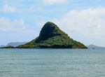
Kayak to Mokoliʻi (Chinaman's Hat), Oahu, Hawaii
Mokoliʻi, also known as Chinaman's Hat, is a basalt islet in Kāne'ohe Bay, Hawaii. Mokoliʻi is part of Kualoa Regional Park and located 1⁄3 miles (0.54 km) offshore of Kualoa Point, Oahu. The 12.5-acre (5.1 ha) islet was at one time part of a basaltic ridge on Oahu before marine erosion separated it. Mokoliʻi is is open to the public from dawn to dusk. It can be... -
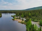
Explore Moon Lake State Recreation Site, Alaska
Moon Lake is north of Tok, Alaska and is a popular playground for locals and tourists alike. The campground can accommodate the largest of RV's. -
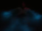
Kayak Mosquito Bioluminescent Bay, Vieques Island, Puerto Rico
Isla de Vieques is an island–municipality of Puerto Rico in the northeastern Caribbean. The Bioluminescent Bay (also known as Puerto Mosquito, Mosquito Bay, or "The Bio Bay"), is considered the best example of a bioluminescent bay in the United States and is listed as a national natural landmark. The luminescence in the bay is caused by micro-organisms, dinoflag... -
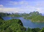
Explore Mu Ko Ang Thong National Park, Thailand
Mu Ko Ang Thong is a marine national park in the Gulf of Thailand located 31 km. west of Samui, Thailand. The parks consists of 42 separate islands, the principle islands being; Phaluai, Wua Ta Lap, Mae Ko, Sam Sao, Hin Dap, Nai Phut and Phai luak. Most of the islands consists of limestone mountains about 10-400 meters above sea level. The eroded limestone gives the i... -
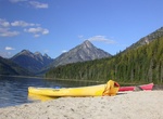
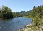
Canoe Murtle Lake, Canada
Murtle Lake is a lava dammed lake located in Wells Gray Provincial Park, east-central British Columbia, Canada. It is fed primarily by the Murtle River which rises from a large unnamed glacier in the Cariboo Mountains at an elevation of 2,300 m (7,546 ft) and flows southwest for 18 km (11 mi) to the lake. The Murtle River also drains Murtle Lake then flows southwest f... -
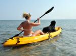
Take My Dog Kayaking
If your dog loves the water then you should take your best friend with you the next time your out kayaking. Of course, you can’t leave your dog behind when your out for a fun day on the water. Sit on top ocean kayaks are the best since they offer more room for your pup to hang out. -
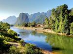
Tube or Kayak Nam Song River, Laos
The Nam Song River is a small river in Laos that flows through the town of Vang Vieng. It is a popular tourist destination as many people enjoy seeing the Laotian countryside while going down the river in the inner tube or in a kayak. The river is surrounded by striking karst rock formations. Upstream from Vang Vieng, numerous bars have been built on the river's banks... -
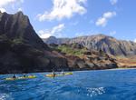
Kayak Nā Pali Coast, Kauai, Hawaii
Kayak the beautiful and iconic Na Pali Coast, what has been called the "Mount Everest" of ocean kayaking. Marvel at sea caves, plunging waterfalls, hanging valleys, and secluded beaches. Along the way it is common to encounter dolphins, sea turtles, and on special occasions you'll catch a glimpse of the elusive Hawaiian monk seal. kayak throught a waterfall to ge... -
Kayak Napa River, California
The Napa River, approximately 55 miles (89 km) long, is a river in the U.S. state of California. It drains a famous wine-growing region, called the Napa Valley, in the mountains northeast of San Francisco. Milliken Creek and Mt. Veeder watersheds are a few of its many tributaries. The mouth is at Vallejo where the inter-tidal zone of fresh and salt waters flow into th... -
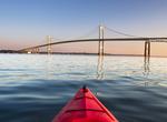
Kayak Narragansett Bay, Rhode Island
Narragansett Bay is a bay and estuary on the north side of Rhode Island Sound and is consideredRhode Island's greatest natural resource.. The bay has 250 mile of coastline and 15 islands, the three largest ones are Aquidneck Island, Conanicut Island, and Prudence Island. For more than 50 years, 12-meter yachts competed on the bay for sailing's prestigious America's C... -
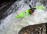
Attend the Narrows of the Green Race, North Carolina
The Narrows of the Green is a 2.9-mile (4.7 km) section of the Green River, in Henderson County and Polk County, between the Big Hungry creek confluence and the Fishtop access area, in western North Carolina, United States. It is roughly 35 miles (56 km) south of downtown Asheville. The Green Narrows is best known for being one of the most extreme kayaking runs in the... -
Canoe or Kayak Nine Mile Pond, Everglades National Park, Florida
Nine Mile Pond is a favorite canoe/kayak location easily accessible off the main park road just before you enter the Flamingo district of the park. You can bring your own canoe or kayak and launch from several locations around the park or rentals are available in the park. Alternatively you could hire a permitted guide who will outfit your trip and lead your adventur... -
Kayak North Santiam River, Oregon
A fun float down the North Santiam River from the Packsaddle park to Fisherman's Bend County Park about 7 miles down the river. This is easy kayaking with Class 1 or 2 rapids and a fun 3-4 foot small waterfall near the end of the trip you can chose to go over or walk around. More Info: Everytrail -
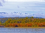
Kayak in Ōkārito Lagoon, New Zealand
Ōkārito Lagoon is a coastal lagoon on the West Coast of New Zealand's South Island. It is located 130 kilometres south of Hokitika, and covers an area of about 12 km², making it the largest unmodified wetland in New Zealand. Several small rivers drain into the lagoon, and it is the outflow of Lake Mapourika. The lagoon is home of many species of wading birds, not...
Price: $208.72