Give us feedback!

Our philosophy is simple. We want to encourage you to dream. BIG! Then we help you plan your trip, get the most out of it while you're traveling and help you share your experience with friends.
Join Now It's FREE
Dreams Still To Do
Checked-Off Dreams
Dreams Still To Do
Checked-Off Dreams
Advertisement
Explore Shipwrecks
-
See Utile Shipwreck, Tromelin Island, French Southern and Antarctic Lands
The French ship Utile most famously refers to the merchant vessel that shipwrecked near Tromelin Island in 1761, abandoning 160 enslaved Malagasy people who were rescued 15 years later. -
See Vanessa Seafood Shipwreck, Namibe Desert, Angola
Vanessa Seafood is a shipwreck on the coast of the Namibe Desert in Angola. -
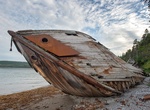
Wreck Dive Van Valkenburg, Lake Huron, Michigan
Lucinda Van Valkenburg was built in 1862 and lost on Lake Huron 25 years later. Bound for Chicago, Illinois, with a load of coal, Lucinda Van Valkenburg was struck by the iron propeller steamer Lehigh about two miles northeast of Thunder Bay Island. The crew was picked up by Lehigh and taken to Port Huron, Michigan. The sunken schooner Lucinda Van Valkenburg presented... -
See Verona Shipwreck, Spiekeroog Island, Germany
The Verona was a steamboat beached December, 13 1883 on Spiekeroog Island. The ship was going from Leith (Scotland) to Bremerhaven. The wreck can still be seen at low tide today. Parts of the ship were removed, but a large part of the ship is still present, but not always visible since it gets covered in sand. -
Visit Visit Michigan Shipwreck, West Coast Trail, Vancouver Island, British Columbia, Canada
The Michigan shipwreck is located along the West Coast Trail (12k) and is the first one you can see and actually touch. On January 21st, 1893 this 695 ton steam schooner was heading to Puget Sound from San Francisco. The strong northerly current that prevails in this part of the Graveyard of the Pacific caused the Michigan to massively overrun her position and run ag... -
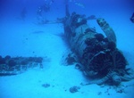
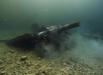
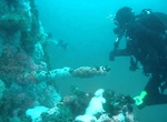
Dive Vought F4U Corsair, Maunalua Bay, Oahu, Hawaii
Vought F4U Corsair is located off Maunalua Bay on Oahu’s southeast shore at a depth of 113 feet. Engine failure forced the plane’s pilot to make an emergency water landing in 1948. The fighter aircraft that saw action in World War II and the Korean War. -
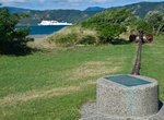
Visit Wahine Memorial Park, Wellington, New Zealand
Wahine Memorial Park marks the disaster with a bow thruster, near where the survivors reached the shore at Seatoun. J. G. Churchill Park in Seatoun has a memorial plaque, the ship's anchor and chain, and replica ventilators. A plaque and the fore mast are at the parking area next to Burdans Gate on the eastern side of the harbour, on the coast where many of the surviv... -
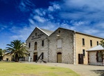
Visit WA Shipwrecks Museum, Fremantle, Western Australia
Restored 1850s-era commissariat building with artifacts documenting shipwrecks & their relics. -
Visit Water Barge Shipwreck, Midway Atoll, Northwestern Hawaiian Islands
The ferro-cement Water Barge ran aground in the 1950's. It's partially submerged and rests in 15 feet of water just east of the USS Macaw. The crumbling remains of the barge extend 20 feet above the sea and serve as a landmark to the main channel. -
Wreck Dive W.G. Mason, Lake Huron, Michigan
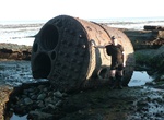
Three well-preserved shipwrecks that tell the story of Rogers City’s limestone industry rest just offshore of the calcite quarry loading docks in clear, shallow water. All three have mooring buoys maintained by Thunder Bay National Marine Sanctuary, and divers, paddlers and snorkelers can easily access them. The Michigan Limestone and Chemical Company (MLCC) pu... -
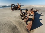
See Wilcox Shipwreck, Anticosti Island, Quebec, Canada
Wilcox was a wooden decommissioned World War II mine sweeper that wrecked on Island of Anticosti remote beach near Pointe-Carleton Lighthouse. There is a campsite nearby. -
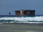
Visit Winston Shipwreck, Skeleton Coast, Namibia
The Winston was a South African wetfish trawler built in 1961 and ran aground on 17 October 1970 in in Durissa Bay, about 23 km north of the Mile 108 campsite. The carcass of the Winston was heavily rusted while today, there is little left of the 180-ton ship. -
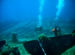
Dive Wreck Alley off San Diego, California
Wreck Alley is an area a few miles off the coast of Mission Beach, San Diego, California with several ships intentionally sunk as artificial reefs and as SCUBA diving attractions for wreck divers. Six of these were intentionally sunk. Ruby E. – Coast Guard cutter El Rey – kelp harvester Yukon – a Canadian navy ship Shooter's Fantasy Barge #1 ... -
Dive WWII Maritime Heritage Trail – Battle of Saipan, Northern Mariana Islands
The Maritime Heritage Trail – Battle of Saipan is located within the protected waters of Saipan lagoon in the Northern Marianas archipelago. The majority of the dive sites including two Japanese shipwrecks, two Japanese aircraft, two US aircraft, a US landing vehicle and two Japanese landing craft can be found in the clear waters between Garapan, Tanapag Harbor,... -
Wreck Dive Yamagiri Maru, Chuuk Lagoon, Micronesia
The Yamagiri Maru was a 133 metre-long passenger/cargo ship. She was hit by a torpedo and sank, coming to rest on her port side at a depth of ~34 metres. One of the holds is packed with 18 inch shells that were being carried for the Yamato and Mushashi battleships. Map location is only an approximate location of the wreck.