Give us feedback!


 See all

Our philosophy is simple. We want to encourage you to dream. BIG! Then we help you plan your trip, get the most out of it while you're traveling and help you share your experience with friends.
Join Now It's FREE
Dream Packages
Duration: 4 days
Price: $663.61
Price: $663.61
Duration: 12 hours
Price: $224.21
Price: $224.21
Duration: 2 days
Price: $398.24
Price: $398.24
Duration: 5 days
Price: $624.00
Price: $624.00
Related Categories
Dreams Still To Do
Checked-Off Dreams
Dreams Still To Do
Checked-Off Dreams
Advertisement
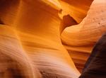
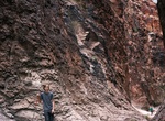
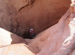
Explore Slot Canyons
-
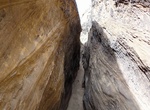
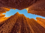
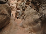
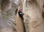
Canyoneer Burro Wash Slot Canyon, Capitol Reef National Park, Utah
Burro Wash slot canyon typify the canyon country of southern Utah: deep, narrow, secret places within the Waterpocket Fold. The routes are largely unmarked. A few rock cairns may mark key points; carrying a topographic map is recommended. It is extremely hot in summer and water sources are unreliable; carry adequate water. Use caution in narrow canyons during flash fl... -
Visit Cañón de Namúrachi, Chihuahua, Mexico
Cañón de Namúrachi is in Chihuahua, Mexico. -
Hike Canyon X, Arizona
Canyon X is a slot canyon just a few feet wide but more than 100 feet deep near Lake Powell in northern Arizona. This canyon has a lot of the same gorgeous features as nearby Antelope Canyon but without the crowds. It is on Navajo land that is privately run and is fenced off. Visits to Canyon X require a Navajo Reservation permit and are limited to four people at a t... -
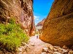
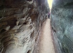
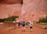
Hike Capitol Gorge Pioneer Trail, Capitol Reef National Park, Utah
Capitol Gorge is a canyon within Capitol Reef National Park in Utah. Capitol Gorge becomes deep and narrow, with several sections of almost slot-like proportions. The gorge was the main route through the park until Highway 24 was built in 1964. The 2 mile round trip hike has Petroglyphs, a pioneer register, and the famous water tanks. This hike follows the gorge for ... -
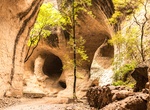
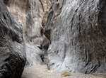
Explore Cathedral & Canyon Caves (Slot Canyons), Nevada
Known locally as "caves," the park's extremely narrow slot canyons were cut from the mud that lay at the bottom of the lake millions of years ago. Explorers can crawl through tunnels to discover hidden chambers in the network of canyons which offer some coolness in the summer heat. -
Canyoneer Cheesebox Canyon, Utah
Cheesebox Canyon is a nice canyoneering canyon in Utah near Utah State Route 95. -
Hike Chesler Park Loop/Joint Trail, Canyonlands National Park, Utah
The Chesler Park Loop/Joint trail is 11 mi (18 km) round-trip trail in the Needles District of Canyonlands National Park. It's a moderate hike, very scenic and provides a multitude of route options to choose from. There are a lot of interesting rock formations along the hike. Three miles along this trail brings visitors to a saddle overlooking Chesler Park, a scenic ... -
Hike Closed Canyon, Big Bend Ranch State Park, Texas
The Closed Canyon Trail is a short hike through a narrow slot canyon. The canyon entrance is visible from the parking area and access is gained by taking a short walk down a low hill, into an arroyo to the opening of the canyon. The canyon leads you toward the Rio Grande River, but river access is not possible without vertical climbing gear. The trailhead is located ... -
Canyoneer Constrychnine Slot Canyon, Utah
Constrychnine is a great, short canyon on the south side of Poison Spring Canyon. Constrychnine is spectacular, with unique rock formations, and dark narrows. The rappels, including a 180+ foot rappel are outstanding! There are three mandatory rappels and one optional rappel, which could be downclimbed. From the wash drop down the first 50' into the canyon proper, ... -
Hike Cottonwood Canyon Narrows, Utah
Cottonwood Canyon Narrows is a nice short hike through the final narrow gorge of Cottonwood Creek before the canyon opens up. Accessed off Road 400 (Cottonwood Canyon Road). -
Hike Cottonwood Marble Loop (Marble Canyon), Death Valley National Park, California
Cottonwood-Marble Canyon Loop is a 26 to 28 miles (42-45km) loop route located in Death Valley National Park. It's only recommended for very experienced adventurers. From CA-190 Enter Stovepipe Wells Campground. Turn left on the Cottonwood Marble Road marked by a sign for the airport. Check conditions prior to travel. Cottonwood Marble Road: 10.5mi (17km). The fir... -
Canyoneer Cottonwood Wash Slot Canyon, Capitol Reef National Park, Utah
Cottonwood Wash slot canyon typify the canyon country of southern Utah: deep, narrow, secret places within the Waterpocket Fold. The routes are largely unmarked. A few rock cairns may mark key points; carrying a topographic map is recommended. It is extremely hot in summer and water sources are unreliable; carry adequate water. Use caution in narrow canyons during fla... -
Hike Coyote Gulch Slots Canyons, Utah
Coyote Gulch is a tributary of the Escalante River, located in Garfield and Kane Counties in southern Utah, in the western United States. Over 25 miles (40 km) long, it exhibits many of the geologic features found in the Canyons of the Escalante, including high vertical canyon walls, narrow slot canyons, domes, arches, and natural bridges. A popular recreational desti... -
Hike Crack in the Ground, Oregon
Over time, earthquakes and volcanos have split and splintered the earth’s surface. Such shocks to the system are not uncommon over the span of six billion years. But still, they have caused many cracks and blisters in the ground. So…why doesn’t more of our earth look like the Grand Canyon, if not “Land of the Lost?” Rock rubble, along w... -
Canyoneer Deadeye Dick Canyon, Utah
Deadeye Dick is outside the Zion National park, so no permit needed. It's a 4 miles from the hike from the trailhead. It's a short canyon with a stunning exit up the narrows. Rating: 3A II (v3a1 II) Rappels: 6,Max↕120ft This route requires a shuttle. It is recommended to combine the descent with Mighty Mouse Canyon, which should add just 1h extra.


Price: $160.26