Give us feedback!


 See all

Our philosophy is simple. We want to encourage you to dream. BIG! Then we help you plan your trip, get the most out of it while you're traveling and help you share your experience with friends.
Join Now It's FREE
Dream Packages
Duration: 50 minutes
Price: $399.32
Price: $399.32
Duration: 40 minutes
Price: $359.02
Price: $359.02
Duration: 3 days
Price: $860.45
Price: $860.45
Duration: 20 minutes
Price: $205.16
Price: $205.16
Related Categories
Dreams Still To Do
Checked-Off Dreams
Dreams Still To Do
Checked-Off Dreams
Advertisement
Explore Top 100 - New Zealand
-
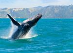
See Whales off Kaikoura Peninsula, New Zealand
The Kaikoura Peninsula is located in the northeast of New Zealand's South Island. It protrudes five kilometres into the Pacific Ocean. The town of Kaikoura is located on the north shore of the peninsula. The peninsula has been settled by Maori for approximately 1000 years, and by Europeans since the 1800’s when whaling operations began off the Kaikoura Coast. Si... -
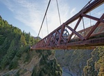
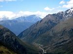
Cross or Jump Off Skippers Canyon Bridge, New Zealand
Skippers Canyon is a historic and scenic gorge, some 22 kilometres in length, that is located several kilometres north of Queenstown. Skippers Canyon houses the Shotover River, one of New Zealand's richest gold bearing rivers which was named by William Gilbert Rees. The first bridge that enabled the gold miners to safely reach Skippers Point was a suspension stru... -
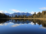
Explore Lake Matheson, New Zealand
Lake Matheson, near the Fox Glacier in South Westland, New Zealand, is famous for its reflected views of snow-capped Aoraki/Mount Cook and Mount Tasman reflected in the dark waters. he waters of Lake Matheson are dark brown, so on a calm day they create the ideal reflective surface. The colour is caused by natural leaching of organic matter from the surrounding native... -
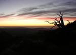
See World's First Summer Sunrise at Mount Hikurangi, New Zealand
Mount Hikurangi (or Te Ara ki Hikurangi in Māori) is a 1754 metre (5755 feet) peak in the northeastern corner of New Zealand's North Island, 60 kilometres (37 miles) southwest of East Cape. It is the North Island's highest non-volcanic peak. The peak is traditionally regarded as the first land in the world to catch the rays of the new day's sun, although this cla... -
Ski or Snowboard a Active Volcano (Mount Ruapehu), New Zealand
Mount Ruapehu, or just Ruapehu, is an active stratovolcano at the southern end of the Taupo Volcanic Zone in New Zealand. It is 23 kilometres northeast of Ohakune and 40 kilometres southwest of the southern shore of Lake Taupo, within Tongariro National Park. The North Island's major skifields and only glaciers are on its slopes. Ruapehu has two commercial ski... -
Explore Whakarewarewa, Rotorua, New Zealand
Whakarewarewa (often abbreviated to Whaka by locals) is a geothermal area within Rotorua city in the Taupo Volcanic Zone of New Zealand. This was the site of the Māori fortress of Te Puia, first occupied around 1325, and known as an impenetrable stronghold never taken in battle. Māori have lived here ever since, taking full advantage of the geothermal activity in the ... -
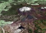
Explore Egmont National Park, New Zealand
Egmont National Park is located south of New Plymouth, close to the west coast of the North Island of New Zealand. It is named after the mountain which dominates its environs, which itself was named by Captain Cook after John Perceval, 2nd Earl of Egmont, the First Lord of the Admiralty who promoted Cook's first voyage. Taranaki has been the Māori name for the mountai... -
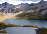
Explore Nelson Lakes National Park, New Zealand
Nelson Lakes National Park is located in the South Island of New Zealand. It was formed in 1956 and covers some 1,020 km². It is centered at two large lakes, Rotoiti and Rotoroa. The park also includes surrounding valleys (including Travers, Sabine, and D'Urville, upper reaches of the Matakitaki) and mountain ranges (Saint Arnaud Range, Mount Robert). The park is... -
Explore Arthur's Pass National Park, New Zealand
Arthur's Pass National Park is located in the South Island of New Zealand. It was established in 1929, becoming the first national park in the South Island and the third in New Zealand. It is bisected by State Highway 73. The road passes through Arthur's Pass village and the mountain pass with the same name over the Southern Alps at a height of 920 metres above sea le... -
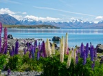
Explore Lake Tekapo, New Zealand
Lake Tekapo is the second-largest of three roughly parallel lakes running north–south along the northern edge of the Mackenzie Basin in the South Island of New Zealand (the others are Lake Pukaki and Lake Ohau). It covers an area of 83 square kilometres (32 sq mi), and is at an altitude of 700 metres (2,300 ft) above sea level. The lake is fed at its northern en... -
Visit New Plymouth, New Zealand
New Plymouth is the major city of the Taranaki Region on the west coast of the North Island of New Zealand. It is named after Plymouth, Devon, England, from where the first English settlers migrated. The city is a service centre for the region's principal economic activities including intensive pastoral activities (mainly dairy farming) as well as oil, natural gas and... -
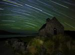
Go Stargazing at Twizel, New Zealand
Twizel is a town in the Mackenzie Basin, part of the Mackenzie District of the Canterbury region of New Zealand's South Island. The area boasts one of the world's cleanest, driest and darkest skies, and has long drawn astronomers to Twizel and the surrounding area, with several existing astro-tourism ventures, such as at Lake Tekapo and Omarama catering to their needs... -
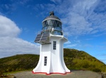
See Cape Reinga Lighthouse, New Zealand
Cape Reinga Lighthouse is a lighthouse at Cape Reinga in the Northland Region of the North Island of New Zealand. It is owned and operated by Maritime New Zealand. The lighthouse is a common New Zealand icon and a popular tourist destination although the lighthouse itself is not open to the public. The lighthouse was built in 1941 and first lit during May of that year... -
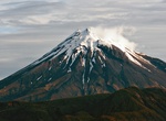
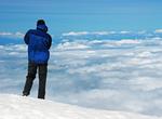
Summit Mount Taranaki, Egmont National Park, New Zealand
Climb through forest, alpine tussock and scoria covered slopes to the 2518 m peak of Mt Taranaki. This track is recommended only in summer conditions unless an experienced mountaineer or with a guide. From December to April, fit and well-equipped trampers can enjoy spectacular scenery from the summit of Mt Taranaki. From May to November, the mountain is covered in s... -
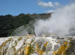
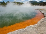
Explore Wai-O-Tapu Thermal Wonderland, New Zealand
Wai-O-Tapu (Māori for “Sacred Waters”) is an active geothermal area at the southern end of the Okataina Volcanic Centre, just north of the Reporoa caldera, in New Zealand's Taupo Volcanic Zone. The area has many hot springs noted for their colourful appearance, in addition to the Lady Knox Geyser. Prior to European occupation the area was the homeland of t...
Price: $183.17