Give us feedback!

Our philosophy is simple. We want to encourage you to dream. BIG! Then we help you plan your trip, get the most out of it while you're traveling and help you share your experience with friends.
Join Now It's FREE
Related Categories
Dreams Still To Do
Checked-Off Dreams
Dreams Still To Do
Checked-Off Dreams
Advertisement
Explore United States Forest Service (USFS)
-
Explore Ouachita National Forest, Arkansas & Oklahoma
The Ouachita National Forest is a vast congressionally-designated National Forest that lies in the western portion of Arkansas and portions of extreme-eastern Oklahoma, USA. The Ouachita National Forest is the oldest National Forest in the southern United States. The forest encompasses 1,784,457 acres (7,221 km2), including most of the scenic Ouachita Mountain Range. ... -
Explore Payette National Forest, Idaho
The Payette National Forest is a U.S. National Forest located in central western Idaho, in parts of Valley, Idaho, Adams, and Washington counties. The land area consists of approximately 2.3 million acres (9,300 km2) of federally managed lands. It is bordered by Hells Canyon National Recreation Area and the Hells Canyon to the west, Salmon-Challis National Forest to t... -
Explore Pike National Forest, Colorado
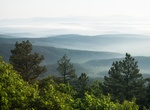
The Pike National Forest is located in the Front Range of Colorado, United States, west of Colorado Springs including Pikes Peak. The forest encompasses 1,106,604 acres (4,478 km2) within Clear Creek, Teller, Park, Jefferson, Douglas and El Paso counties. The major rivers draining the forest are the South Platte and Fountain Creek. Rampart Reservoir is a large artific... -
Explore Pisgah National Forest, North Carolina
Pisgah National Forest is a National Forest in the Appalachian Mountains of western North Carolina. It is administered by the United States Forest Service, part of the United States Department of Agriculture. The Pisgah National Forest is completely contained within the state of North Carolina. The forest is managed together with the other three North Carolina Nationa... -
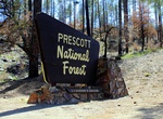
Explore Prescott National Forest, Arizona
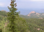
The Prescott National Forest is a 1.25 million-acre (510,000 ha) United States National Forest located in north central Arizona in the vicinity of Prescott. The forest is located in the mountains southwest of Flagstaff and north of Phoenix in Yavapai County, with a small portion (about 3.5 percent) extending into southwestern Coconino County. The Forest Service divide... -
Explore Red River Gorge, Kentucky
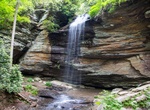
The Red River Gorge is a canyon system on the Red River in east-central Kentucky. Geologically, it is part of the Pottsville Escarpment. The gorge lies within the Daniel Boone National Forest and has been subsequently designated as the Red River Gorge Geological Area, an area of around 29,000 acres (120 km2; 45 sq mi). It has been designated a National Natural Landmar... -
Explore Rogue River–Siskiyou National Forest, Oregon and California
The Rogue River–Siskiyou National Forest is a United States National Forest in the U.S. states of Oregon and California. The formerly separate Rogue River and Siskiyou National Forests were administratively combined in 2004. Now, the Rogue River–Siskiyou National Forest ranges from the crest of the Cascade Range west into the Siskiyou Mountains, covering a... -
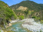
Drive Rogue-Umpqua National Scenic Byway, Oregon
Discover the Rogue-Umpqua Scenic Byway, a stunning 172-mile drive along the North Umpqua and Upper Rogue Wild & Scenic Rivers to their headwaters in the heart of the Southern Cascades. The drive owes its dramatic scenery and incredible landscapes to a fiery volcanic past. From rolling hills to 9,000 foot peaks, from whitewater rivers to cascade lakes, this travel... -
Explore Sand to Snow National Monument, California
Sand to Snow National Monument is a U.S. National Monument area located in the state of California between San Bernardino National Forest and Joshua Tree National Park. Encompassing 154,000 acres, including just over 100,000 acres of already congressionally-designated Wilderness, Sand to Snow National Monument is an ecological and cultural treasure and one of the most... -
Explore San Gabriel Mountains National Monument, California
The San Gabriel Mountains are a mountain range located in northern Los Angeles County and western San Bernardino County, California, United States. The mountain range lies between the Los Angeles Basin and the Mojave Desert, with Interstate 5 to the west and Interstate 15 to the east. This Transverse Range lies in, and is surrounded by, the Angeles National Forest, wi... -
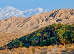
Explore Santa Rosa and San Jacinto Mountains National Monument, California
The Santa Rosa and San Jacinto Mountains National Monument is a National Monument in Southern California. It includes portions of the Santa Rosa and San Jacinto Mountain ranges, the northernmost ones of the Peninsular Ranges system. The national monument covers portions of Riverside County, west of the Coachella Valley, approximately 100 miles (160 km) southeast of do... -
Explore Sáttítla National Monument, California
Sáttítla National Monument protects over 200,000 acres in the Medicine Lake Highlands of the Modoc, Klamath, and Shasta-Trinity National Forests. Sáttítla National Monument will be managed by the US Forest Service as a unified whole despite being in three different National Forests. -
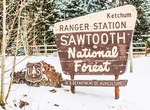
Explore Sawtooth National Forest, Idaho
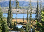
Sawtooth National Forest is a National Forest that covers 2,110,408 acres (854,052 ha) in the U.S. states of Idaho (~96 percent) and Utah (~4 percent). Managed by the U.S. Forest Service in the U.S. Department of Agriculture, it was originally named the Sawtooth Forest Reserve in a proclamation issued by President Theodore Roosevelt on May 29, 1905. On August 22, 1972... -
Explore Shawnee National Forest, Harrisburg, Illinois
The Shawnee National Forest is a United States National Forest located in the Ozark and Shawnee Hills of Southern Illinois, United States. Administered by the U.S.D.A. Forest Service, it consists of approximately 280,000 acres (1,100 km²) of federally managed lands. In descending order of land area it is located in parts of Pope, Jackson, Union, Hardin, Alexander... -
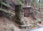
Explore Sierra National Forest, California
Sierra National Forest is a U.S. national forest located on the western slope of central Sierra Nevada in Central California and bounded on the northwest by Yosemite National Park and the south by Kings Canyon National Park. The forest is known for its mountain scenery and beautiful lakes. Forest headquarters are located in Clovis, California. There are local ranger d...