Give us feedback!

Our philosophy is simple. We want to encourage you to dream. BIG! Then we help you plan your trip, get the most out of it while you're traveling and help you share your experience with friends.
Join Now It's FREE
Dream Packages
See all
Related Categories
Dreams Still To Do
Checked-Off Dreams
Dreams Still To Do
Checked-Off Dreams
Advertisement
Explore US Territories
-
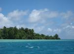
Visit American Samoa
American Samoa is a group of islands in the South Pacific Ocean that lie about halfway between Hawaii and New Zealand and about 100 km east of the island country of Samoa, which is part of the same archipelago. The main city is Pago Pago and the smaller Fagatogo is constitutionally designated seat of government. The governor's office is located in the village of Utule... -
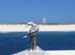
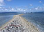
Visit Bajo Nuevo Bank (Petrel Islands)
Bajo Nuevo Bank, also known as the Petrel Islands, is a small, uninhabited reef with some small islets, covered with grass, located in the western Caribbean Sea with a lighthouse on Low Cay. The closest neighbouring land feature is Serranilla Bank, located 110 kilometres (68 miles) to the west. The reef was first shown on Dutch maps dating to 1634 but was given its pr... -
Visit Baker Island National Monument
Baker Island is an uninhabited atoll located just north of the equator in the central Pacific Ocean about 3,100 kilometres (1,700 nmi; 1,900 mi) southwest of Honolulu. The island lies almost halfway between Hawaii and Australia, and is a possession of the United States. Its nearest neighbor is Howland Island, 68 kilometres (37 nmi; 42 mi) to the north. The island cove... -
Visit Guam
Guam is an organized, unincorporated territory of the United States located in the western Pacific Ocean. It is one of five U.S. territories with an established civilian government. The island's capital is Hagåtña (formerly Agaña). Guam is the largest and southernmost of the Mariana Islands. The Chamorros, Guam's indigenous people, first populated ... -
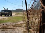
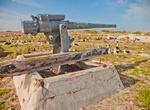
Visit Guantanamo Bay Naval Base
Guantanamo Bay Naval Base (also called Gitmo or GTMO) is located on 45 square miles (120 km2) of land and water at Guantánamo Bay, Cuba which the United States leased for use as a coaling (fueling) station following the Cuban-American Treaty of 1903. The base is located on the shore of Guantánamo Bay at the southeastern end of Cuba. It is the oldest over... -
Visit Howland Island National Monument
Howland Island is an uninhabited coral island located just north of the equator in the central Pacific Ocean, about 1,700 nautical miles (3,100 km) southwest of Honolulu. The island lies almost halfway between Hawaii and Australia and is an unincorporated, unorganized territory of the United States. Geographically, it is part of the Phoenix Islands. For statistical pu... -
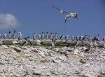
Visit Jarvis Island National Monument
Jarvis Island (formerly known as Bunker Island) is an uninhabited 4.5 square kilometer (1.75 sq. mile) coral island located in the South Pacific Ocean about halfway between Hawaii and the Cook Islands. It is an unincorporated, unorganized territory of the United States, administered by the United States Fish and Wildlife Service of the United States Department of the ... -
Visit Johnston Atoll National Monument
Johnston Atoll is a 1.03 sq mi (2.7 km2) atoll in the North Pacific Ocean about 750 nmi (860 mi; 1,390 km) west of Hawaii. Johnston Atoll is a National Wildlife Refuge and is closed to public entry. Limited access for management needs is only by Letter of Authorization from the U.S. Air Force and Special Use Permit from the U.S. Fish and Wildlife Service. There are fo... -
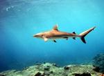
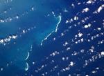
Visit Kingman Reef National Monument
Kingman Reef is a largely submerged, uninhabited triangular shaped reef, 9.5 nautical miles (18 km) east-west and 5 nautical miles (9 km) north-south, located in the North Pacific Ocean, roughly half way between the Hawaiian Islands and American Samoa. It is the northernmost of the Northern Line Islands and lies 36 nautical miles (67 km) northwest of the next closest ... -
Visit Midway Atoll (Midway Island), Northwestern Hawaiian Islands
Midway Atoll (also called Midway Island, Midway Islands, Kuaihelani and Pihemanu) is a 2.4-square-mile (6.2-km²) atoll in the North Pacific Ocean, near the northwestern end of the Hawaiian archipelago, about a third of the way between Honolulu, Hawaii, and Tokyo, Japan. Uniquely among the Hawaiian islands, Midway observes UTC-11 (also known as Samoa Time), eleven... -
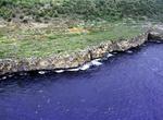
Visit Navassa Island
Navassa Island is a small, uninhabited island in the Caribbean Sea, claimed as an unorganized unincorporated territory of the United States, which administers it through the U.S. Fish and Wildlife Service. Haiti, which claims sovereignty over Navassa since 1801, also claims the island in its constitution. Navassa Island is about 2 square miles (5.2 km2). It is found a... -
Visit Northern Mariana Islands
The Northern Mariana Islands, officially the Commonwealth of the Northern Mariana Islands (CNMI), is a commonwealth in political union with the United States, occupying a strategic region of the western Pacific Ocean. It consists of 15 islands about three-quarters of the way from Hawaii to the Philippines. More than 90% of the population lives on the island of Saipan.... -
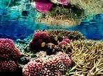
Visit Palmyra Atoll National Monument (Palmyra Atoll)
Palmyra Atoll is an essentially unoccupied equatorial Northern Pacific atoll administered as an unorganized incorporated territory by the United States federal government. The variable temporary population of 4–20 'non-occupants' are essentially staff and scientists employed by various departments of the U.S. federal government and The Nature Conservancy, as wel... -
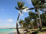
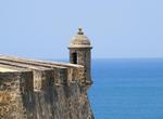
Visit Puerto Rico
Puerto Rico is a Caribbean island that is a self-governing commonwealth of the United States of America. Located in the Caribbean Sea to the east of the Dominican Republic and west of the U.S. Virgin Islands, Puerto Rico lies on a key shipping lane to the Panama Canal, the Mona Passage. Puerto Rico has a tropical marine climate, which is mild and has little seasonal t... -
Visit Serranilla Bank
Serranilla Bank (Isla Serranilla or Banco Serranilla) is a partially submerged reef, with small uninhabited islets, in the western Caribbean Sea. It is situated about 350 kilometres (220 mi) northeast of Punta Gorda, Nicaragua, and roughly 280 kilometres (170 mi) southwest of Jamaica. The closest neighbouring land feature is Bajo Nuevo Bank, located 110 km to the east...

Price: $947.75