Give us feedback!

Our philosophy is simple. We want to encourage you to dream. BIG! Then we help you plan your trip, get the most out of it while you're traveling and help you share your experience with friends.
Join Now It's FREE
Dreams Still To Do
Checked-Off Dreams
Dreams Still To Do
Checked-Off Dreams
Advertisement
Explore US Wilderness Areas
-
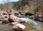
Explore Frank Church—River of No Return Wilderness, Idaho
The Frank Church—River of No Return Wilderness Area is a protected wilderness area in Idaho. It was created in 1980 by the United States Congress and renamed in 1984 as theFrank Church-River of No Return Wilderness Areain honor of U.S. Senator Frank Church. At 2.367 million acres (9,580 km2), it is the second largest protected wilderness in the contiguous United... -
Explore Garden of the Gods Wilderness, Illinois
The Garden of the Gods Wilderness is a 3,318-acre (13.43 km2) parcel of land listed as a Wilderness Area of the United States. It is located within the Shawnee National Forest in Hardin, Pope, Saline, and Gallatin counties in the U.S. state of Illinois. The nearest town of any size is Equality. During the Carboniferous period (circa 300 million years before the p... -
Explore Gila Wilderness, New Mexico
Gila Wilderness was designated the world's first wilderness area on June 3, 1924. Along with Aldo Leopold Wilderness and Blue Range Wilderness, the 558,014 acres (225,820 ha) (872 sq. mi.) wilderness is part of New Mexico's Gila National Forest. The wilderness is approximately 27 miles (43 km) from north to south and 39 miles (63 km) east to west. U.S. Wilderness Area... -
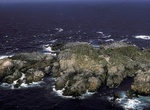
Explore Hazy Islands Wilderness, Alaska Maritime National Wildlife Refuge, Alaska
Hazy Islands Wilderness, at 32 acres (16 ha), is Alaska's smallest wilderness area. It was officially designated as Wilderness in 1970 by the United States Congress. The islands are located west of Coronation Island in the Alaska Panhandle area. Hazy Islands Wilderness comprises five small islands and is home to 10 species of birds, including Brandt's cormorant(Phalac... -
Explore Hellsgate Wilderness, Arizona
The Hellsgate Wilderness is a 37,440-acre (151.5 km2) protected wilderness within the Tonto National Forest located in Gila County, Arizona, at the base of the Mogollon Rim. It was created by the U.S. Congress in 1984 and is managed by the U.S. Forest Service. The Hellgsate Wilderness contains many trails for hiking as well as camping spots. However, usage of this are... -
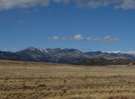
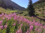
Explore Holy Cross Wilderness, Colorado
The Holy Cross Wilderness is a U.S. Wilderness Area located in San Isabel and White River national forests near Leadville, Minturn, Avon, Edwards, Eagle, and Vail, Colorado. The 122,797-acre (496.94 km2) wilderness with 164 miles (264 km) of trails was established in 1980. The wilderness was named after its highest peak, 14,005-foot (4,269 m) Mount of the Holy Cross. ... -
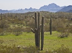
Explore Hummingbird Springs Wilderness, Arizona
The Hummingbird Springs Wilderness is a 31,200-acre (12,626 ha) wilderness administered by the Bureau of Land Management (BLM). The wilderness is located in the northwest of Maricopa County in northern regions of the central Sonoran Desert of Arizona. This 31,200- acre wilderness lies 55 miles west of Phoenix in western Maricopa County. The colorful escarpments of the... -
Explore Ireteba Peaks Wilderness, Nevada
Climb a peak named after a leader of the Mojave people? Check. Roam alongside bighorn sheep among pinyon and juniper trees? Yep. Traverse varied terrain that changes from steep canyons at higher elevations to rolling hills, to shallow desert washes across a broad bajada? Ireteba has all that too. Get your pack horse saddled and your compass ready. Let’s explore ... -
Explore Jarbidge Wilderness (Nevada)
The Jarbidge Wilderness is a wilderness area located in the Jarbidge Mountains of northern Elko County in northeastern Nevada, United States. It is contained within the Jarbidge Ranger District of the Humboldt-Toiyabe National Forest. "Jarbidge" is a name derived from the Shoshone language meaning "devil". Indians believed the hills in the area were haunted. The origi... -
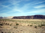
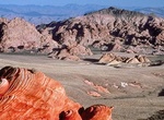
Explore Jimbilnan Wilderness, Nevada
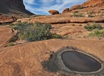
The Jimbilnan Wilderness Area is 18,879 acres located near and including the northeastern end of the Black Mountains. This rugged and mountainous terrain contrasts beautifully with the flat surface water of Lake Mead, which can often be seen in the distance. Jimbilnan is also known for its colorful sand dunes, which provide a home for two rare plants--the Beaver Dam m... -
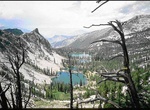
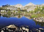
Explore John Muir Wilderness, California
The John Muir Wilderness is a wilderness area that extends along the crest of the Sierra Nevada of California, USA for 90 miles (140 km), in the Inyo and Sierra National Forests. Established in 1964 by the Wilderness Act and named for naturalist John Muir, it contains 581,000 acres (2,350 km2). The wilderness lies along the eastern escarpment of the Sierra from near M... -
Explore Juniper Dunes Wilderness, Washington
The Juniper Dunes Wilderness is a protected wilderness area comprising 7,140 acres (28.9 km²) in Franklin County, Washington. Established in 1984, it is noteworthy for the northernmost growth of western juniper trees that live among the area's large sand dunes. Currently no legal access to Juniper Dunes Wilderness exists, as the entire surrounding land is private... -
Explore Kanab Creek Wilderness, Arizona
Kanab Creek Wilderness is a 75,300-acre (305 km2) wilderness area located along the Coconino/Mohave County line in the U.S. state of Arizona, approximately 30 miles (48 km) south of Fredonia. 68,600 acres (278 km2) of the Wilderness are located in the North Kaibab Ranger District of the Kaibab National Forest, the remaining 6,700 acres (27 km2) are administered by the... -
Explore Lizard Head Wilderness, Colorado
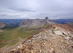
The Lizard Head Wilderness is a wilderness area in southwest Colorado. It contains 41,309 acres (167.17 km2) and is jointly managed by the Uncompahgre and San Juan National Forests. It is 10 miles (16 km) southwest of the town of Telluride and is named for a prominent rock formation that is said to look like a lizard's head. Lizard Head itself is 13,113 feet (3,997 m)... -
Explore Lye Brook Wilderness, Green Mountain National Forest, Vermont
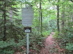
The Lye Brook Wilderness is one of eight wilderness areas in the Green Mountain National Forest in the U.S. state of Vermont. It is managed by the U.S. Forest Service. The wilderness area was created by the Eastern Wilderness Areas Act of 1975, which makes it one of the oldest wilderness areas in the state. The area was expanded by both the Vermont Wilderness Act of 1...