Give us feedback!


 See all

Our philosophy is simple. We want to encourage you to dream. BIG! Then we help you plan your trip, get the most out of it while you're traveling and help you share your experience with friends.
Join Now It's FREE
Dream Packages
Duration: 10 hours
Price: $133.63
Price: $133.63
Duration: 17 hours
Price: $639.99
Price: $639.99
Duration: 3 hours 30 minutes
Price: $87.96
Price: $87.96
Related Categories
Dreams Still To Do
Checked-Off Dreams
Dreams Still To Do
Checked-Off Dreams
Advertisement
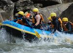
Explore Whitewater Rafting & Kayaking
-
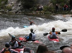
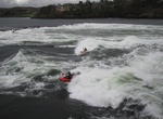
Kayak or Surf Charlie's Hole (Yampa River), Steamboat Springs, Colorado
The Yampa River in Steamboat Springs has the A, B, and D holes, but the C-Hole, or Charlie’s Hole is the best. It’s surfable on SUPs and shortboards if flows are good. -
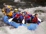
Whitewater Raft Clackamas River, Oregon
The Clackamas is one of the premier white water rivers in Oregon and is within easy reach of anywhere in the Portland metro area. -
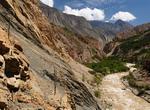
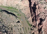
Explore Cotahuasi Canyon, Peru
Cotahuasi Canyon near the city of Arequipa in Peru is the deepest canyon in the world. Its maximum depth is 3535 metres in the vicinity of Ninancocha, 335 metres more than the Colca Canyon. The Cotahuasi Canyon is an impressive chasm that the river has eroded between two enormous mountain massifs: the Coropuna (6425 m.s.n.m.) and the Solimana (6093 m.s.n.m.). One exte... -
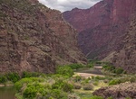
Raft or Kayak Dinosaur National Monument, Colorado
Whitewater rafting is a popular way to experience Dinosaur National Monument's remote canyons. From origins high in the Rocky Mountains, the Green and Yampa Rivers wind their way across sagebrush covered plains before entering this outstretched arm of the Unita Mountains. The mountains force the rivers into tight channels surrounded by towering cliffs. Drops and obstr... -
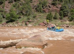
White Water Raft Dolores River, Colorado
The lower stretch of the Dolores River offers technical rapids, stunning scenery, wildlife viewing, side-canyon hiking, and great camping. A free permit is required. Groups must read and adhere to all stipulations of the permit. Call the Moab Field Office at 435-259-2100 to secure a free permit for floating the Dolores River. Rapids on this section of the Dolores Riv... -
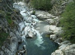
Kayak El Rio Claro, Parque Nacional Radal Siete Tazas, Chile
Kayak one of the narrowest rivers in the world - the El Rio Claro River in Chile. The Rio Claro, literally translating as ‘Clear River’, is 2-3 hours south of the big city of Santiago, near a good sized town named Molina. -
See Falls of Lora, Connel, Scotland
The Falls of Lora is a tidal race which forms at the mouth of Loch Etive when a particularly high tide runs out from the loch. They form white water rapids for two to five days either side of the spring tides. The falls of Lora are generated when the water level in the Firth of Lorn (i.e. the open sea) drops below the level of the water in Loch Etive as the tide goes ... -
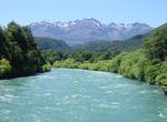
Raft or Kayak Futaleufú River, Chile
Whitewater rafting enthusiasts count an adventure on the glacier fed Futaleufu River in the Patagonian region of Chile among their favorite trips. Futaleufu, translated as “Big River” in the local dialect, is a rafter’s dream with aqua blue water in an alpine setting. Large waves, ever present boulders and Class III to Class V rapids provide all the ... -
Raft or Kayak Gates of Lodore (Green River), Dinosaur National Monument, Colorado
The Gates of Lodore is the scenic entrance to the Canyon of Lodore, a canyon on the Green River in northwestern Colorado, United States. The name Gates of Lodore has become synonymous with the canyon itself and the two names are used interchangeably. The Canyon commences as the Green River departs Browns Park and cuts through the Uinta Mountains meandering eighteen mi... -
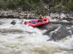
Raft or Kayak Gauley River National Recreation Area, West Virginia
The 25 miles of free-flowing Gauley River and the six miles of the Meadow River pass through scenic gorges and valleys containing a wide variety of natural and cultural features. The Gauley River contains several class V+ rapids, making it one of the most adventurous white water boating rivers in the east. The Gauley River National Recreation Area, located near Summer... -
Whitewater Raft or Kayak Golo River, Corsica
The Golo River is a fun whitewater expereince. Good for beginner or an intermediate rafters. -
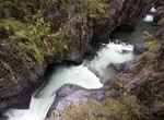
Kayak Grand Canyon of the Stikine, British Columbia, Canada
The Grand Canyon of the Stikine is a 45 mile (72 km) stretch of the Stikine River in northern British Columbia, Canada. It has been compared to the Grand Canyon of the Colorado. The canyon is home to a large population of mountain goats and other wildlife. Officially the canyon is described as unnavigable by any watercraft, however there have been 15 successful descen... -
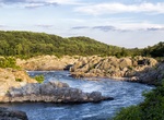
Explore Great Falls Potomac River, Virginia
The Great Falls of the Potomac River are located at the fall line of the Potomac River, 14 miles (23 km) upstream from Washington, D.C. Great Falls Park, operated by the National Park Service, is located on the southern banks in Virginia, while Chesapeake and Ohio Canal parkland is located along the northern banks of the river in Maryland. The Potomac and the falls th... -
Tube Guadalupe River, San Antonio Bay
The Guadalupe River (/ˌɡwɑːdəˈlup/) (Spanish pronunciation: [gwaðaˈlupe]) runs from Kerr County, Texas, to San Antonio Bay on the Gulf of Mexico, with an average temperature of 17.75 degrees Celsius (63.95 degrees Fahrenheit). It is a popular destination for rafting, fly fishing, and canoeing. Larger cities along it include Kerrville, New Braunfels, Seguin, Gonzal... -
Explore Gulkana Wild and Scenic River, Alaska
The Gulkana River watershed drains approximately 2,140 square miles of Southcentral Alaska. The river begins in the Alaska Range near Summit Lake and flows south into the Copper River, which eventually empties into the Gulf of Alaska between Cordova and Katalla. Several hundred lakes and ponds are scattered throughout the spruce-dominated forest of the Gulkana River w...
Price: $149.15