Give us feedback!

2002 Crater Excursion - Northern Etna
Package Details
Destination:
CT, Sicilia, Italy
Duration: 2 to 3 hours
Price:
$36.34
Details & Booking at viator.com
Like & Rate this package!
Offered by: Viator
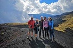
The 2002 crater tour is one of the most popular destinations chosen by tourists on the northern slopes of Etna, far from the chaos of the southern slope, allowing you to savor the authenticity of the Etna volcanic environment in total tranquility, immersed in uncontaminated nature. Our guests accompanied by our Guides will be immersed in a whole new world, passing by the remains of the tourist infrastructures, the castings, the green of the woods and finally the craters surrounded by lunar landscapes, all in a path of just over 4, 5 km round trip.
Possibility to rent boots / jacket on the spot.
Program:
Meeting at the Etna Nord Volcanological Guides office in Piano Provenzana at 10:30 am.
Departure from Piano Provenzana at 1800 meters at 11:00.
Initial briefing.
Beginning of the trek.
Visit to eruptive fractures up to a maximum altitude of 2100 meters.
Descent on trekking to the starting point.
Total duration: 3h
Difficulty: T (Tourist).
Itinerary
This is a typical itinerary for this product
Stop At: Via Provenzana 37 Localita Piano Provenzana, 95015 Linguaglossa, Sicily Italy
Beginning of the trek along the dirt road that from Piano Provenzana leads to the summit craters of the volcano, after the first kilometer you cross the eruptive fracture of the eruption of 27 October 2002 on the path of "Monte Nero - Timpa Rossa", the path allows you to visit and study the multiple volcanic morphologies relating to the eruptions that followed one another on the north side of Etna, in particular the flank eruptions of 10 September 1911 and 17 June 1923 which threatened the town of Linguaglossa. After visiting the particular volcanic morpho-structures called Hornitos from the Spanish "Piccolo forno", we will go up along the pyroclastic cones of the 2002 eruption until reaching the maximum altitude of 2100 meters on the crater rim, the path ends with the descent into a sandy channel to the starting point.
The route has a total length of 4.5 km.
Useful information:
Minimum starting altitude: 1800 m - maximum altitude reached: 2100 m.
Total height difference, uphill: 300 m (variable value) - Height difference, downhill: 300 m.
Total Km: 4.5
Compulsory equipment:
Layered clothing (short-sleeved shirt - long-sleeved thermal shirt - fleece or sweatshirt) - (varies according to season)
Trekking shoes
Windbreaker or down jacket (variable according to the season)
Water - minimum 1.5 L
Duration: 3 hours