Give us feedback!

4 Days Chisapani Nagarkot Dhulikhel shortTrek from kathmandu
Package Details
Destination:
Kathmandu, Central Region, Nepal
Duration: 4 days
Price:
$320.00
Details & Booking at viator.com
Like & Rate this package!
Offered by: Viator
One of the most interesting short trekking routes in Nepal, 4 Days Chisapani- Nagarkot Short Trek brings you closer to nature and the traditional culture. A moderately difficult route allows you to check out the most intelligently done terraced farming techniques. Also, During the whole trek, the cold air breezing will refresh you like nothing else. It further boosts your inner sense and helps you see the world in a whole new dimension. Shivapuri National Park will be the area where if lucky you can get a glimpse of wild animals and birds.
Highlights
• Interaction in the green lush forests
• Face off with the culture and traditions of local people
• Watching sunrise and sunset from Nagarkot will be an experience of a lifetime
• Get a totality of diversified experience of bird watching, hiking, and sunrise view
Highlights
• Interaction in the green lush forests
• Face off with the culture and traditions of local people
• Watching sunrise and sunset from Nagarkot will be an experience of a lifetime
• Get a totality of diversified experience of bird watching, hiking, and sunrise view
Itinerary
Day 1: Kathamndu-Sundarijal-Chisapani[LD]
Stop At: Chisapani, Chisapani, Bheri Zone, Mid-Western Region
Kathmandu by Private Vehicle to Sundarijal, drive approximately 1 hours and trek to chisapani (2135 m)walk approximately 4-5 hours
Duration: 4 hours
Meals included:
• Lunch
• Dinner
Accommodation included: Overnight at tea house lodge.
Day 2: Chisapani-Nagarkot [BLD]
Stop At: Nagarkot, Nagarkot, Bagmati Zone, Central Region
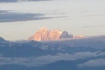
Chisapani to Nagarkot (2155 m)walk approximately 6-7 hours Nagarkot is located 32 km east of Kathmandu, Nepal in Bhaktapur. At the time of the 1991 Nepal census it had a population of 3,504 and had 655 houses in it. At an elevation of 2,195 meters, it is renowned for its sunrise view of the Himalaya including Mount Everest as well as other snow-capped peaks of the Himalayan range of eastern Nepal. Nagarkot also offers a panoramic view of the Kathmandu Valley.Nagarkot is an international tourist destination with spectacular views of the whole Langtang range, sunrise on the mountains and sunset views.Located approximately 7000 ft (2000 m) above sea level and 32 km from Kathmandu International Airport, Nagarkot is a world famous hills station commanding breathtaking views of the majestic Himalayas, rolling hills, deep valleys, lush pine forests in a quaint rural atmosphere. Situated in a strategic location, Nagarkot was an ancient fort of the Kathmandu valley to monitor external activities of other kingdoms. Later, it became a summer retreat places for the royals before becoming popular as an international hill station
Duration: 6 hours
Meals included:
• Breakfast
• Lunch
• Dinner
Accommodation included: Overnight at tea house lodge.
Day 3: Nagarkot-Dhulikhel [BLD]
Stop At: Dhulikhel, Dhulikhel, Bagmati Zone, Central Region
Nagarkot to Dhulikhel (2010 m)walk approximately 5-6 hours Dhulikhel is the administrative centre of Kavrepalanchok District, Nepal. At the time of the 2011 Nepal census it had a population of 14,283 people in 3,279 households. Dhulikhel lies along the B.P. Highway and Arniko Highway. Arniko Highway connects Kathmandu, Nepal's capital city with Tibet's border town of Kodari. Dhulikhel is located at the Eastern rim of Kathmandu Valley, south of the Himalayas at 1550m above sea level and is situated 30 km southeast of Kathmandu and 74 km southwest of Kodari. The people in the village are Newars, Brahmin, Chhettri, Tamang and Dalit. Drinking water in Dhulikhel is some of the best water in Nepal. It was made with the Help of the German NGO, German Technical Cooperation.
Duration: 6 hours
Meals included:
• Breakfast
• Lunch
• Dinner
Accommodation included: Overnight at tea house lodge.
Day 4: Dhulikhel-Kathmandu/1 hr/ [B]
Stop At: Kathmandu, Kathmandu, Kathmandu Valley, Bagmati Zone, Central Region
After breakfast drive to Kathmandu by private car and drop at your hotel.
Duration: 2 hours
Meals included:
• Breakfast
No accommodation included on this day.