Give us feedback!
 4.0 from partner site

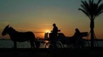
4-Hour Walking and Horse Carriage City Tour of Cairo
Package Details
Destination:
Cairo, Cairo Governorate, Egypt
Duration: 3 to 5 hours
Price:
$45.00
Details & Booking at viator.com
Like & Rate this package!
4.0 from partner site
Offered by: Viator
Explore the city of Cairo while comfortably sitting in a horse carriage. Pass by one of the most richest areas in Cairo and go along the Nile Corniche. After the horse carriage tour you will have a walking tour in the most famous areas downtown, where modern malls and shops are located. Visit the most famous square in Egypt, El Tahrir Square and pay an external visit to Cairo Tower, one of the modern highlights in Egypt.
Itinerary
This is a typical itinerary for this product
Pass By: Cairo Tower, El-Andalus, Cairo 11511 Egypt
The Cairo Tower (Arabic: برج القاهرة, Burj Al-Qāhira) - commonly known to locals as "Nasser's Pineapple" (Arabic: اناناسة ناصر Ananas Nasser)[2] - is a free-standing concrete tower in Cairo, Egypt. At 187 m (614 ft), it has been the tallest structure in Egypt and North Africa for about 50 years. It was the tallest structure in Africa for ten years until 1971, when it was surpassed by Hillbrow Tower in South Africa.
One of Cairo's well-known modern monuments, sometimes considered Egypt's second most famous landmark after the Pyramids of Giza, it stands in the Gezira district on Gezira Island in the River Nile, close to downtown Cairo.
Pass By: Liberation Square (Midan El-Tahreer), In Front of the Egyptian Museum, Cairo 11511 Egypt
Tahrir Square (Arabic: ميدان التحرير Mīdān at-Taḥrīr, IPA: [meˈdæːn ettæħˈɾiːɾ], English: Liberation Square), also known as "Martyr Square", is a major public town square in downtown Cairo, Egypt. The square has been the location and focus for political demonstrations in Cairo, most notably those that led to the 2011 Egyptian revolution and the resignation of President Hosni Mubarak.
Pass By: Nile River Valley, Nile River Valley
The Nile (Arabic: النيل, romanized: an-Nīl[needs Arabic IPA]) is a major north-flowing river in northeastern Africa, and is the longest river in Africa and the disputed longest river in the world,[2][3] as the Brazilian government says that the Amazon River is longer than the Nile.[4][5] The Nile, which is about 6,650 km (4,130 mi)[n 1] long, is an "international" river as its drainage basin covers eleven countries: Tanzania, Uganda, Rwanda, Burundi, the Democratic Republic of the Congo, Kenya, Ethiopia, Eritrea, South Sudan, Republic of the Sudan, and Egypt.[7] In particular, the Nile is the primary water source of Egypt and Sudan.