Give us feedback!

Peaks of Balkans / Albania - Kosovo - Montenegro
Package Details
Destination:
Tirana, Albania, Albania
Duration: 10 days
Price:
$1574.52
Details & Booking at viator.com
Like & Rate this package!
Offered by: Viator
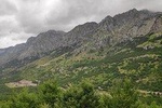
The region of Dinaric Alps spreading across the north of Albania, the southwest of Kosovo, and the east of Montenegro which is also called “ Accursed Mountains”, counts to the least known areas in South East Europe. Until now, the mountain region of Kosovo, Montenegro and Albania has virtually remained untouched and is only sparsely inhabited. Thus, it has preserved its fascination and authentic character. The region is known for hospitality of its habitants, which visitors can enjoy while staying in one of the traditional houses that can be found along the trail in all three countries. The variety of accommodation ranges from traditional stone houses, so called “Kullas” , to mountain huts and small mountain lodges where local and house-made dishes are served by the local hosts.
SMART TOUR ALBANIA - Tour operator
SMART TOUR ALBANIA - Tour operator
Itinerary
Day 1: Theth to Valbona
Stop At: Theth National Park, Rruga Nikgjonaj Rruga Nikgjonaj, Nr.18, Theth 4009 Albania
Trail distance: 13.9 kilometers
Elevation min: 745 meters max: 1,759 meters
Cumulative height uphill: 1,068 meters
downhill: 792 meters
Difficulty level: Moderate
Time: 7 hours
Duration: 7 hours
Meals included:
• Breakfast
• Lunch
• Dinner
Accommodation included: Guesthouse
Day 2: Valbone to Cerem
Stop At: Valbona Valley National Park, Valbona Albania
Trail distance: 19.8 kilometers
Elevation min: 670 meters max: 1,156 meters
Cumulative height uphill: 541 meters
downhill: 382 meters
Difficulty level: Easy
Time: 7 hours
Duration: 7 hours
Meals included:
• Breakfast
• Lunch
• Dinner
Accommodation included: Guesthouse
Day 3: Cerem to Deberdol
Stop At: Albania, Albania
Trail distance: 15.64 kilometers
Elevation min: 1,152 meters max: 1,920 meters
Cumulative height uphill: 1,025 meters downhill: 440 meters
Difficulty level: Moderate
Time: 6 hours
Duration: 6 hours
Meals included:
• Breakfast
• Lunch
• Dinner
Accommodation included: Guesthouse
Day 4: Deberdol to Milishevc
Stop At: Malishevë
Trail distance: 18.2 kilometers
Elevation min: 1,534 meters max: 2,290 meters
Cumulative height uphill: 915 meters downhill: 980 meters
Difficulty level: Moderate
Time: 8-9 hours
Duration: 9 hours
Meals included:
• Breakfast
• Lunch
• Dinner
Accommodation included: Guesthouse
Day 5: Milishevc - Reke
Stop At: Rekë
Trail distance: 16.24 kilometers
Elevation min: 910 meters max: 2,136 meters
Cumulative height uphill: 863 meters downhill: 1,277 meters
Difficulty level: Moderate
Time: 8-9 hours
Duration: 8 hours
Meals included:
• Breakfast
• Lunch
• Dinner
Accommodation included: Guesthouse
Day 6: Reke to Kucishte
Stop At: Drelë
Trail distance: 23.26 kilometers
Elevation min: 1,072 meters max: 1,820 meters
Cumulative height uphill: 1,257 meters downhill: 1,139 meters
Difficulty level: Moderate
Time: 8-9 hours
Duration: 9 hours
Meals included:
• Breakfast
• Lunch
• Dinner
Accommodation included: Guesthouse
Day 7: Kucishte to Babino Polje
Stop At: Babino Polje, Babino Polje, Mljet Island, Dubrovnik-Neretva County, Dalmatia
Trail distance: 15.8 kilometers
Elevation min: 1,438 meters max: 2,276 meters
Cumulative height uphill: 1,151 meters downhill: 1,109 meters
Difficulty level: Moderate
Time: 7-8 hours
Duration: 8 hours
Meals included:
• Breakfast
• Lunch
• Dinner
Accommodation included: Guesthouse
Day 8: Babino Polje to Plave
Stop At: Plav, Plav, Plav Municipality
Trail distance: 20.31 kilometers
Elevation min: 953 meters max: 2,068 meters
Cumulative height uphill: 719 meters downhill: 1,250 meters
Difficulty level: Moderate
Time: 7-8 hours
Duration: 8 hours
Meals included:
• Breakfast
• Lunch
• Dinner
Accommodation included: Guesthouse
Day 9: Plav to Vusanje
Stop At: Vusanje, Vusanje, Gusinje Municipality
Trail distance: 27.4 kilometers
Elevation min: 968 meters max: 2,106 meters
Difficulty level: Moderate
Time: 10 – 11 hours
Duration: 11 hours
Meals included:
• Breakfast
• Lunch
• Dinner
Accommodation included: Guesthouse
Day 10: Vusanje to Theth
Stop At: Theth, Theth, Shkoder County
Trail distance: 21.35 kilometers
Elevation min: 726 meters max: 1,748 meters
Accumulative height uphill: 1,111 meters downhill: 1,437 meters
Time: 8 hours
Difficulty level: Moderate
Duration: 8 hours
Meals included:
• Breakfast
• Lunch
• Dinner
Accommodation included: Guesthouse