Give us feedback!

Quilotoa Lake full day from Quito
Package Details
Destination:
Quito, Pichincha Province, Ecuador
Duration: 8 to 10 hours
Price:
$200.00
Details & Booking at viator.com
Like & Rate this package!
Offered by: Viator
On this day trip, you will visit one of the most beautiful lagoons hidden in the crater of an extinct volcano, who is
located few hours from Quito (the capital city of Ecuador) and surrounded by beautiful Andean landscapes you will be amazed by the beautiful
emerald color of the lagoon of Quilotoa.
located few hours from Quito (the capital city of Ecuador) and surrounded by beautiful Andean landscapes you will be amazed by the beautiful
emerald color of the lagoon of Quilotoa.
Itinerary
This is a typical itinerary for this product
Stop At: Tigua, Tigua, Cotopaxi Province
Visit a Galery of one of the painters of this interesting community. you could delight with the colors and how they represent their culture and living.
Duration: 20 minutes
Stop At: Canon del Rio Toachi, Kilometros Del Canton Sigchos 10, Pujili 050450 Ecuador
It is a product of the pyroclastic flows from the eruption of the Quilotoa volcano. The last eruption happened around 1280 and was one of the largest volcanic eruptions in the past 1000 years. However geological excavations of the site suggest that the canyon itself is around 1800 years old, meaning that it was formed by a previous eruption. The flow of lava from Quilotoa was responsible for generating the undeniably spectacular canyon, which is home to wildlife, forests and a river. The canyon runs from the Quilotoa volcano and eventually fades into the landscape.
Duration: 20 minutes
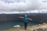
Stop At: Laguna Quilotoa, Laguna de Quilotoa, 070701 Ecuador
Quilotoa is a water-filled crater lake and the most western volcano in the Ecuadorian Andes. The 3-kilometre (2 mi)-wide caldera was formed by the collapse of this dacite volcano following a catastrophic VEI-6 eruption about 800 years ago, which produced pyroclastic flows and lahars that reached the Pacific Ocean, and spread an airborne deposit of volcanic ash throughout the northern Andes. The caldera has since accumulated a 250-metre-deep (820 ft) crater lake, which has a greenish color as a result of dissolved minerals. Fumaroles are found on the lake floor and hot springs occur on the eastern flank of the volcano.
Duration: 4 hours