Give us feedback!

Visit Top 25 Star Wars Destinations
›Go to Dream PageDream out of
Stats for this Dream
On Your list: -
Your Check-offs: -
Friends with Dream: 0
Total Check-offs: -
Advertisement
-
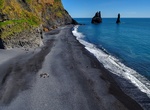
Visit Reynisfjara Black Sand Beach, Iceland
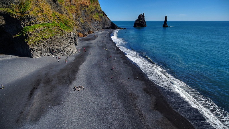 A quick word about the place...Flag as inappropriate ›The Black Sand Beach near the village Vík í Mýrdal in southern Iceland is unique and there are also interesting rock formations. At the eastern end of the beach are the Reynisdrangar Pillars, basalt sea stacks situated under the mountain Reynisfjall. It's here the Star Wars "Rogue One" movie's lead, Jyn Erso, played by Felicity Jones, unsuccessfully tries to save her grievously wounded father.
 -
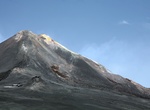
Explore Mount Etna, Sicily, Italy (UNESCO Site)
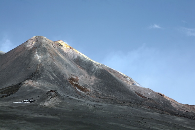 A quick word about the place...Flag as inappropriate ›Mount Etna is an active stratovolcano on the east coast of Sicily, close to Messina and Catania. It is the tallest active volcano in Europe, currently standing 3,329 metres (10,922 ft) high, though this varies with summit eruptions; the mountain is 21 m (69 ft) higher than it was in 1981.. It is the highest mountain in Italy south of the Alps. Etna covers an area of 1,190 km² (460 sq mi) with a basal circumference of 140 km. This makes it by far the largest of the three active volcanoes in Italy, being about two and a half times the height of the next largest, Mount Vesuvius. Only Mount Teide in Tenerife surpasses it in the whole of the European-North-African region. In Greek Mythology, the deadly monster Typhon was trapped under this mountain by Zeus, the god of the sky. Mount Etna is one of the world’s most active volcanoes and is in an almost constant state of activity. The fertile volcanic soils support...SHOW MORE
 -
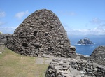
Visit Skellig Michael, Ireland (UNESCO site)
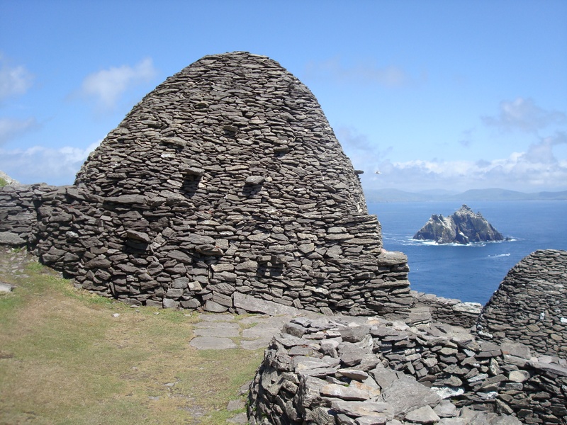 A quick word about the place...Flag as inappropriate ›Skellig Michael (from Sceilig Mhichíl in the Irish language, meaning Michael's rock), also known as Great Skellig, is a steep rocky island in the Atlantic Ocean about 9 miles (14.5 kilometres) from the coast of County Kerry, Ireland. It is the larger of the two Skellig Islands. After probably being founded in the 7th century, for 600 years the island was a centre of monastic life for Irish Christian monks. The Gaelic monastery, which is situated almost at the summit of the 230-metre-high rock became a UNESCO World Heritage Site in 1996. It is one of Europe's better known but least accessible monasteries. Since the extreme remoteness of Skellig Michael has until recently discouraged visitors, the site is exceptionally well preserved. The very spartan conditions inside the monastery illustrate the ascetic lifestyle practiced by early Irish Christians. The monks lived in stone 'beehive' huts (clochans), perched above...SHOW MORE
 -
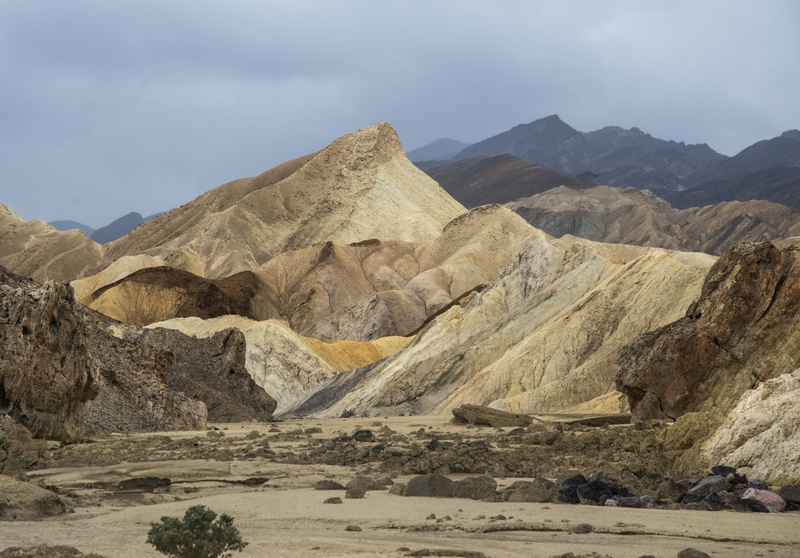
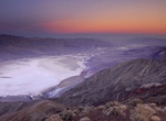
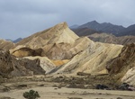
Drive to Dante's View, Death Valley National Park, California
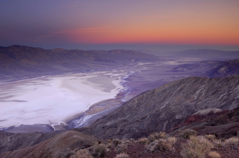 A quick word about the place...Flag as inappropriate ›Dante's View is a viewpoint terrace at 1,669 m (5,475 feet) height, on the north side of Coffin Peak, along the crest of the Black Mountains, overlooking Death Valley. Dante's View is about 25 km (15 miles) south of Furnace Creek in Death Valley National Park. From the Dante's View parking lot, visitors can take several paths, one of which leads to the very brink of the edge, offering a dramatic panoramic view. Another path leads north 320 m (350 yards) to a rest area with picnic tables. The best time to visit Dante's View is in the cooler morning hours, when the sun is in the east. Dante's View is an excellent venue for night time star viewing with telescopes. Dante's View provides a panoramic view of the southern Death Valley basin. To the south, the Owlshead Mountains, 30 km (19 miles) away can be seen, and to the north, the Funeral Mountains 50 km (31 miles) distant, are visible beyond Furnace Creek. To the West, across...SHOW MORE
 -
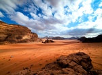
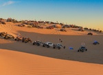
Explore Wadi Rum, Jordan
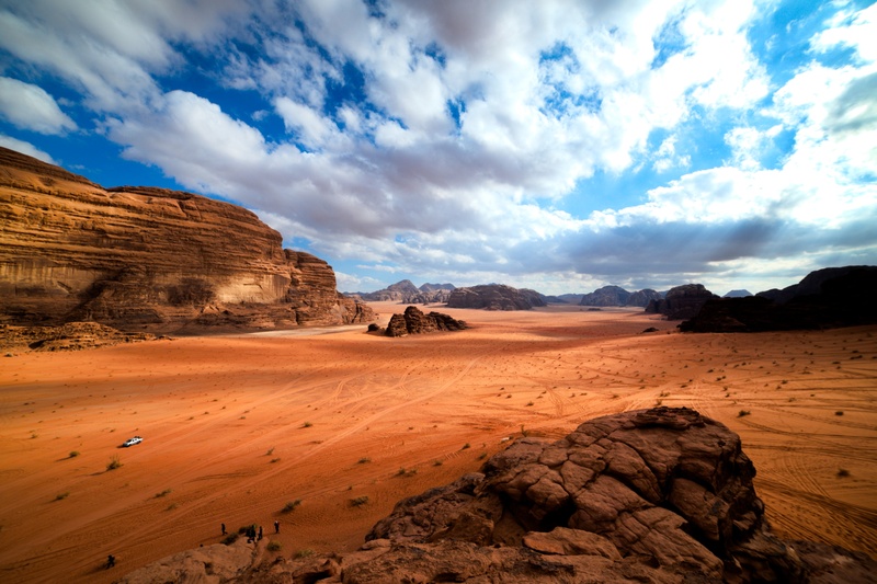 A quick word about the place...Flag as inappropriate ›Wadi Rum also known as The Valley of the Moon is a valley cut into the sandstone and granite rock in south Jordan at 60 km to the east of Aqaba. It is the largest wadi in Jordan. The name Rum most likely comes from an Aramaic root meaning 'high' or 'elevated'. To reflect its proper Arabic pronunciation, archaeologists transcribe it as Wadi Ramm. The highest elevation in Wadi Rum is Mount Um Dami at more than 1800m above sea level. Wadi Rum has been inhabited by many human cultures since prehistoric times, with many cultures–including the Nabateans–leaving their mark in the form of rock paintings, graffiti, and temples. As of 2007, several Bedouin tribes inhabit Rum and the surrounding area. In the West, Wadi Rum may be best known for its connection with British officer T. E. Lawrence, who based his operations here during the Arab Revolt of 1917–18. In the 1980s one of the rock formations in Wadi Rum was named...SHOW MORE
 -
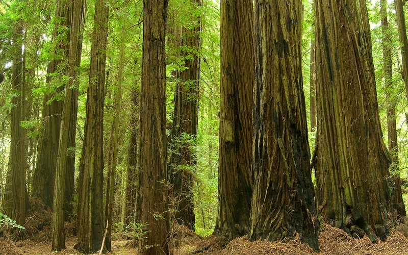
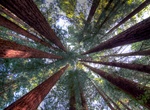
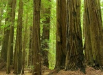
Explore Humboldt Redwoods State Park, California
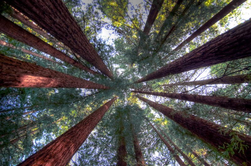 A quick word about the place...Flag as inappropriate ›Humboldt Redwoods State Park is a state park of California, United States, containing Rockefeller Forest, the world's largest remaining contiguous old-growth forest of coast redwoods. It is located 30 miles (48 km) south of Eureka, California, near Weott in southern Humboldt County, within Northern California. It was established by the Save-the-Redwoods League in 1921 largely from lands purchased from the Pacific Lumber Company. Beginning with the dedication of the Raynal Bolling Memorial Grove, it has grown to become the third-largest park in the California State Park system, now containing 51,651 acres (20,902 ha) through acquisitions and gifts to the state. The park is famed for its coast redwoods (Sequoia sempervirens), many of which grow to over 300 feet (91 m) in height. The forests on alluvial plains are almost pure redwood forest, but the forests on the slopes also contain Coast Douglas-fir. The park has a 5-mile (8.0...SHOW MORE
 -
Explore Krafla Caldera, Iceland
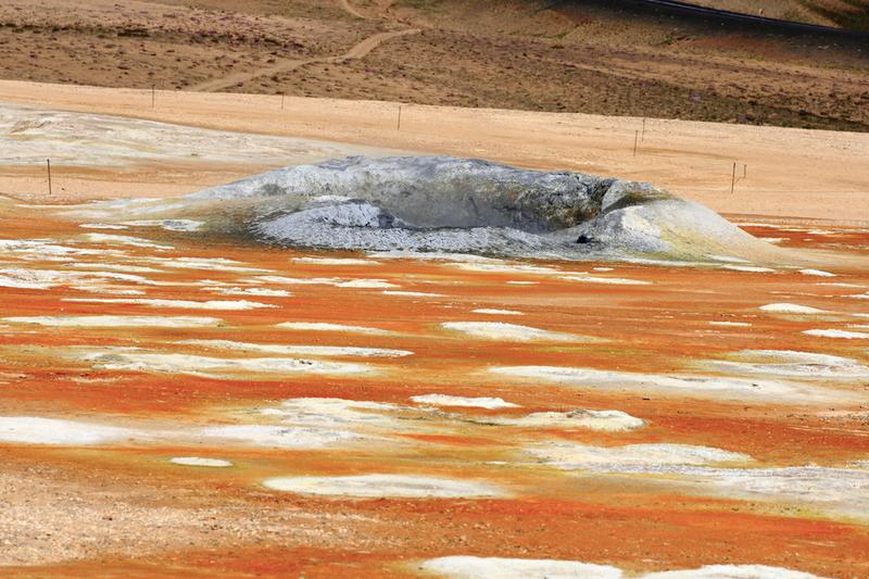 A quick word about the place...Flag as inappropriate ›Krafla is a caldera of about 10 km in diameter with a 90 km long fissure zone, in the north of Iceland in the Mývatn region. Its highest peak reaches up to 818 m and it is 2 km in depth. There have been 29 reported eruptions in recorded history. Krafla includes one of the two best-known Víti craters of Iceland (the other is in Askja). The Icelandic word "víti" means "hell". In former times, people often believed hell to be under volcanoes. The crater Víti has a green lake inside of it. The Krafla area also includes Námafjall, a geothermal area with boiling mudpools and steaming fumaroles. The Mývatn fires occurred between 1724–29, when many of the fissure vents opened up. The lava fountains could be seen in the south of the island and a lava flow destroyed three farms near the village of Reykjahlíð, although nobody was harmed. Between 1975 and 1984 there was a volcanic...SHOW MORE
 -
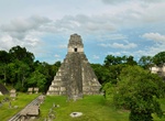
Explore Tikal National Park, Guatemala (UNESCO)
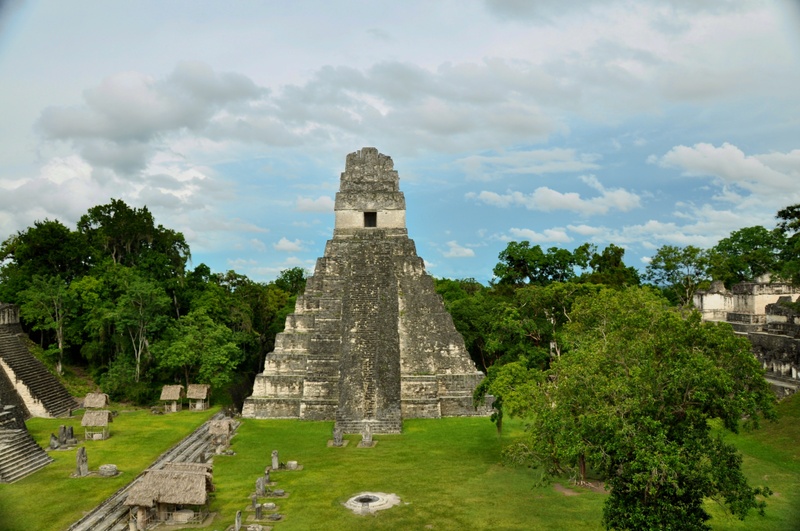 A quick word about the place...Flag as inappropriate ›Tikal is the ruin of an ancient city, which was likely to have been called Yax Mutal, found in a rainforest in Guatemala. Ambrosio Tut, a gum-sapper, reported the ruins to La Gaceta, a Guatemalan newspaper, which named the site Tikal. After the Berlin Academy of Sciences' magazine republished the report in 1853, archeologists and treasure hunters began visiting the forest. Today tourism to the site may help protect the rainforest. It is one of the largest archaeological sites and urban centers of the pre-Columbian Maya civilization. It is located in the archaeological region of the Petén Basin in what is now northern Guatemala. Situated in the department of El Petén, the site is part of Guatemala's Tikal National Park and in 1979 it was declared a UNESCO World Heritage Site. Tikal was the capital of a conquest state that became one of the most powerful kingdoms of the ancient Maya. Though monumental architecture...SHOW MORE
 -
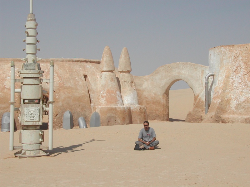
Visit Ajim, Tunisia
 A quick word about the place...Flag as inappropriate ›Ajim is a town and port located on the Island of Djerba off the coast of Tunisia. It is Djerba's main fishing port and the closest city to the African continent. The city and surrounding areas were used as a filming location forStar Wars. Tourists can visit buildings featured in the original movie, including Obi-Wan Kenobi's house and the Mos Eisley Cantina.
 -
Visit Medenine, Tunisia
 A quick word about the place...Flag as inappropriate ›Medenine is the major town in south-eastern Tunisia, 77 kilometres (48 mi) south of the port of Gabès and the Island of Djerba, on the main route to Libya. It is the capital of Medenine Governorate. In pre-colonial times, Medenine was already the most important trading centre in the south, attracting merchants from all over North Africa and even from Bornu, to the south of the Sahara. The Ksar housed the central granaries of the various nomadic Berber tribes of the region. The area was the scene of an unsuccessful German counter-attack by General Erwin Rommel as part of Operation Capri during March 1943 against British Eighth Army forces. The Battle of Medenine was Rommel's last engagement in Africa before he was replaced by General Hans-Jürgen von Arnim as commander of the Afrika Korps. When Anakin was a slave boy in Star Wars "The Phantom Menace," his quarters were filmed on this real-life Tunisian street (Avenue...SHOW MORE
 -
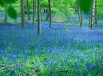
Explore Whippendell Woods, Watford, England
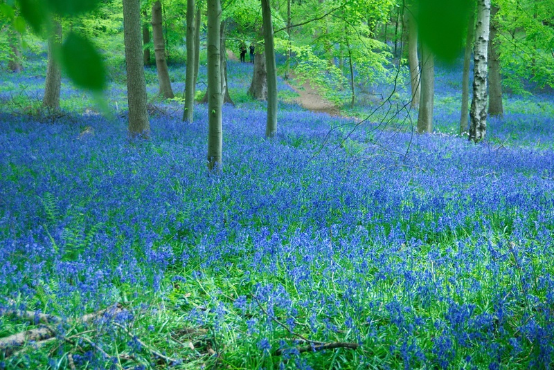 A quick word about the place...Flag as inappropriate ›Whippendell Wood (or Whippendell Woods) is an ancient woodland on the edges of Watford, England, covering an area of 165.3 acres (66.9 ha). It is owned and managed by Watford Borough Council. It is a Site of Special Scientific Interest, and has held this status since 1954. Its present name comes from the Anglo-Saxon name "Wippa denu", meaning "Wippa's valley". Whippendell Wood has been designated a Site of Special Scientific Interest, due to its diverse range of fungi and invertebrates. Originally, it was listed in 1954 with Harrocks Wood, but was declared as an SSSI on its own in 1986. A range of trees can be found in the wood, which is predominantly composed of oak, beech, ash and silver birch. There are also a significant number of cherry, hawthorn, hazel, holly and hornbeam trees. Sycamore trees are also found in the wood, but these are being felled as part of a management plan, as they are not native to the area. The wood...SHOW MORE
 -
Visit Canary Wharf Underground Station, London, England
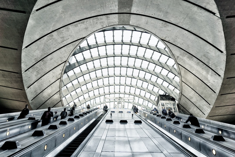 A quick word about the place...Flag as inappropriate ›Canary Wharf is a London Underground station on the Jubilee line, between Canada Water and North Greenwich. The station, serving Canary Wharf, is in Travelcard Zone 2 and was opened by Ken Livingstone setting an escalator in motion on 17 September 1999 as part of the Jubilee Line Extension. It is maintained by Tube Lines. Over 40 million people pass through the station each year, making it second busiest on the London Underground outside Central London after Stratford, and also the busiest that serves only a single line. Above ground there is little sign of the vast interior: two curved glass canopies at the east and west ends of the station cover the entrances and allow daylight into the ticket hall below. The Jubilee Park, a public park is situated between the two canopies, above the station concourse. It had originally been intended that the infilled section of the dock would be reinstated above the station, but this proved...SHOW MORE
 -
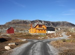
Visit Finse, Norway
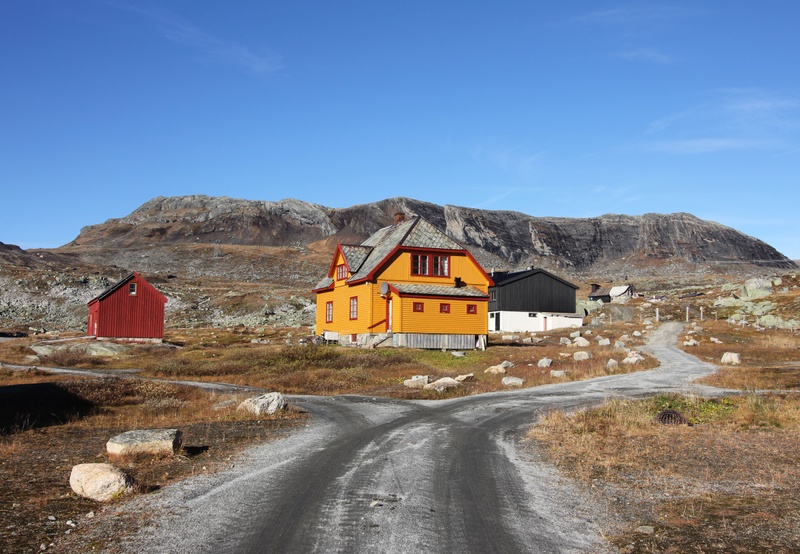 A quick word about the place...Flag as inappropriate ›Finse is a mountain village area on the shore of the lake Finsevatnet in Ulvik municipality in Hordaland county, Norway. The village is centered on Finse Station, a railway station on the Bergensbanen railway line. The village sits at an elevation of 1,222 metres (4,009 ft) above sea level, making it the highest station on the entire Norwegian railway system. The village lies in the eastern part of Ulvik municipality, and it is not easily accessible from the rest of the municipality. There is no road access, only a railway stop. The long Finse Tunnel lies just west of the village area, replacing a difficult section of rail that frequently was blocked by snow and difficult to clear. Since there are no (public) roads to Finse, the railway provides the sole means of transportation to and from Finse. During summer, however, it is possible to walk or cycle to Finse on the Rallarvegen road (owned by the railroad). Across the railway...SHOW MORE
 -
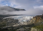
See Hardangerjøkulen Glacier, Norway
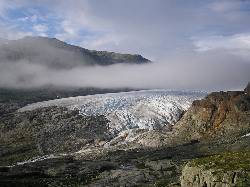 A quick word about the place...Flag as inappropriate ›Hardangerjøkulen is the sixth largest glacier in mainland Norway. It is located in the municipalities of Eidfjord and Ulvik in Hordaland county. It is located about 16 kilometres (9.9 mi) northeast of the village of Eidfjord, about 5 kilometres (3.1 mi) south of Finse, and about 20 kilometres (12 mi) west of Haugastøl. Hardangerjøkulen's highest point is 1,863 m (6,112 ft) above sea level, and is the highest point in Hordaland county. Its lowest point is 1,050 m (3,440 ft) above sea level. The thickest measurement of the glacier was 380 metres (1,250 ft) thick, but it has been getting thinner during the 20th century. The glacier is easily accessed from the north in the winter, from the village of Finse, which is only accessible by stopping at Finse Station on the Bergensbanen railway line. In the winter the highest point can be accessed from Finse using only skis. The 1980 movieThe Empire Strikes Backused...SHOW MORE
 -
Explore Grizzly Creek Redwoods State Park, California
 A quick word about the place...Flag as inappropriate ›Grizzly Creek Redwoods State Park is a state park of California, USA, harboring groves of coast redwoods in three separate units along the Van Duzen River. It is located 20 miles (32 km) east of Eureka, California, then another 18 miles (29 km) east of Fortuna on State Route 36. The small park was created by a donation from Owen R. Cheatham, founder of Georgia-Pacific Corporation, who wanted to preserve the stand of redwoods in perpetuity. Originally established in 1943, the park has grown to 430 acres (170 ha). The Cheatham Grove unit, 4 miles (6.4 km) west of the main unit, was added to the park in 1983 due to efforts of the Save-the-Redwoods League. The park is so secluded due to its location off the major regional artery, U.S. Route 101, that on a weekday a visitor can be the only person in any one of the several groves.SHOW MORE
 -
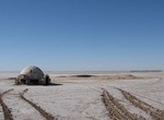
Visit Lars Family Homestead (Luke Skywalker's Igloo Home), Chott El Je...
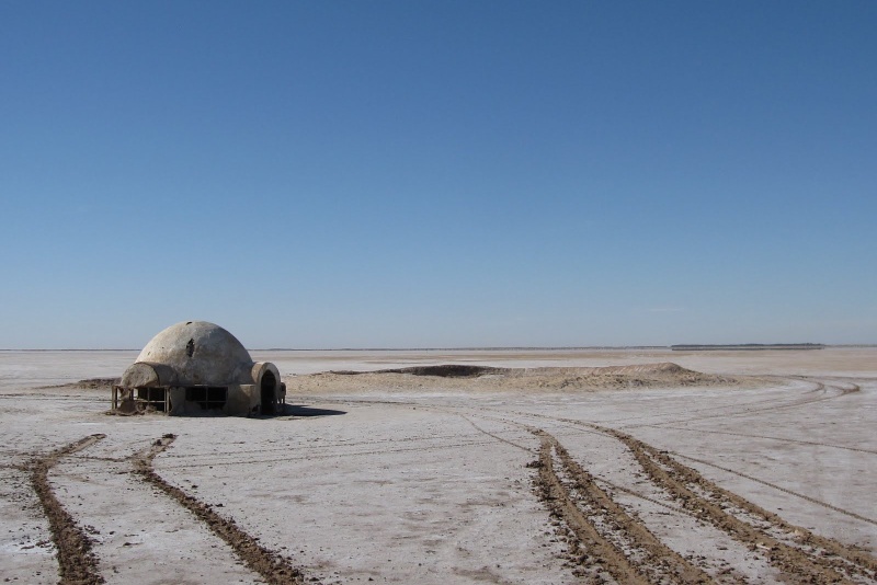 A quick word about the place...Flag as inappropriate ›The igloo exterior of Luke's house was filmed about 300 kilometers away on the dried-up salt lake of Chott El Jerid, Tunisia. This little building is in the middle of nowhere and was abandoned after first movie shooting was wrapped. It was deteriorating but was refurbished when the later prequels once again had use for it. After the prequels it once again was abandoned and began to fall apart again. Now group of dedicated fans have been restoring the hut so that it can last for future Star Wars fans.
 -
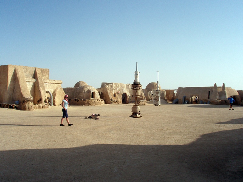
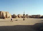
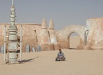
Visit Mos Espa (Annakin Village), Nefta, Tunisia
 A quick word about the place...Flag as inappropriate ›The salt-flats of near Nefta were used as a filming location for the Star Wars saga.
 -
Visit Imperial Sand Dunes Recreation Area (Algodones Dunes, Glamis), C...
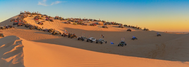 A quick word about the place...Flag as inappropriate ›The Imperial Sand Dunes Recreation Area (Algodones Dunes) is a large erg (sand dune field) located in the southeastern portion of the U.S. state of California, near the border with Arizona and the Mexican state of Baja California. The field is approximately 45 miles long by 6 miles wide and extends along a northwest-southeast line that correlates to the prevailing northerly and westerly wind directions. The name "Algodones Dunes" refers to the entire geographic feature, while the administrative designation for that portion managed by the Bureau of Land Management is the Imperial Sand Dunes Recreation Area (sometimes called the Glamis Dunes). The Algodones Dunes are split into many different sections. These sections include Glamis, Gordon's Well, Buttercup, Midway, and Patton's Valley. The three most popular areas Mammoth Washcamping area is a BLM-managed, dispersed camping area located on the north end of the Imperial Sand...SHOW MORE
 -
Drive Twenty-Mule Team Canyon, Death Valley National Park, California
 A quick word about the place...Flag as inappropriate ›A 2.7 mile (4.3k), one-way, dirt road winds through Twenty Mule Team Canyon which is an area of barren land once used by the Twenty-Mule Teams. The drive is worthwhile and is accessible to all passenger vehicles except busses, RV’s and trailers. Twenty-mule teams were teams of eighteen mules and two horses attached to large wagons that ferried borax out of Death Valley from 1883 to 1889. They traveled from mines across the Mojave Desert to the nearest railroad spur, 165 miles (275 km) away in Mojave. The routes were from the Harmony and Amargosa Borax Works to Daggett, California, and later Mojave, California. After Harmony and Amargosa shut down in 1888, the mule team's route was moved to the mines at Borate, 3 miles east of Calico, back to Daggett. There they worked from 1891 until 1898 when they were replaced by the Borate and Daggett Railroad. The wagons were among the largest ever pulled by draft animals, designed...SHOW MORE
 -
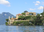
Visit Villa del Balbianello & Gardens, Lake Como, Italy
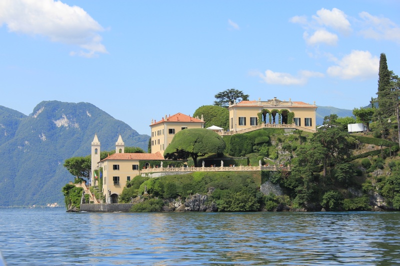 A quick word about the place...Flag as inappropriate ›The Villa del Balbianello is a villa in the town of Lenno, Italy, overlooking Lake Como. It is located on the tip of a small wooded peninsula on the western shore of the south-west branch of Lake Como, not far from the Isola Comacina and is famous for its elaborate terraced gardens.c The villa was built in 1787 on the site of a Franciscan monastery for the Cardinal Angelo Maria Durini. The two towers which can be seen in the picture are the campanili of the convent church. After the cardinal’s death in 1796 Giuseppe Arconati Visconti bought the villa and made improvements to its gardens and the loggia. In the nineteenth century the villa belonged to the Porro-Lambertenghi family. The writer and patriot Silvio Pellico was a visitor in 1819. By the early twentieth century the buildings had fallen into a state of neglect when an American businessman, Butler Ames, purchased and renovated the villa and its garden. In 1974 it...SHOW MORE
 -
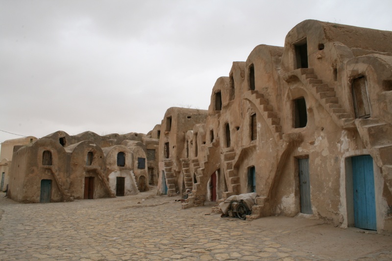
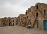
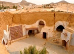
Stay at Hotel Sidi Driss, Matmata, Tunisia
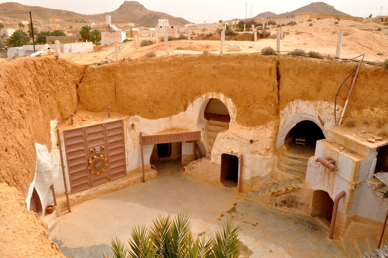 A quick word about the place...Flag as inappropriate ›The Hotel Sidi Driss in Matmata was used in 1976 as a filming location for Star Wars Episode IV: A New Hope in which it featured as the home of Luke Skywalker, his Aunt Beru Lars and Uncle Owen Lars on the planet Tatooine. The hotel is designed as a traditional Berber troglodyte underground building. It featured again in the 2002 prequel film Star Wars Episode II: Attack of the Clones.
 -
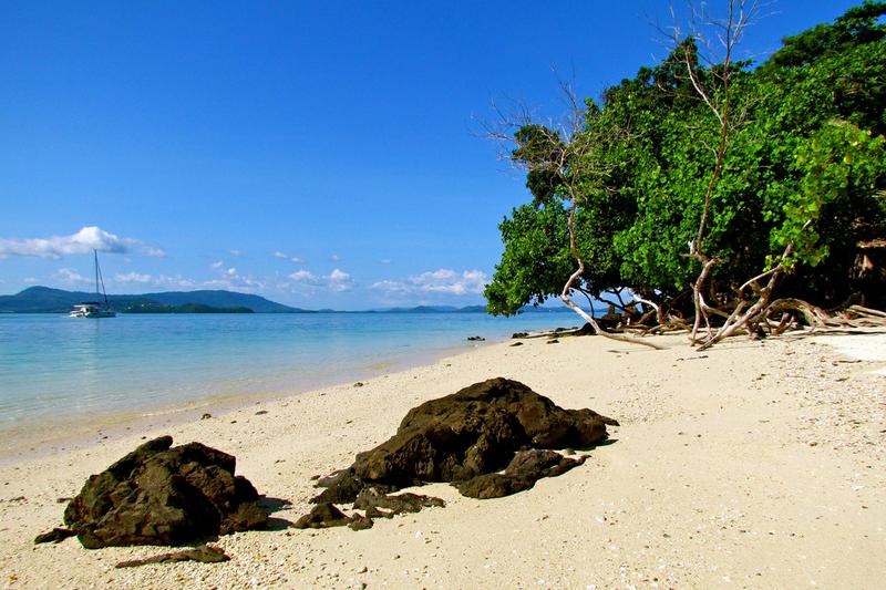
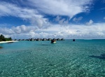
Visit Laamu Atoll, Maldives
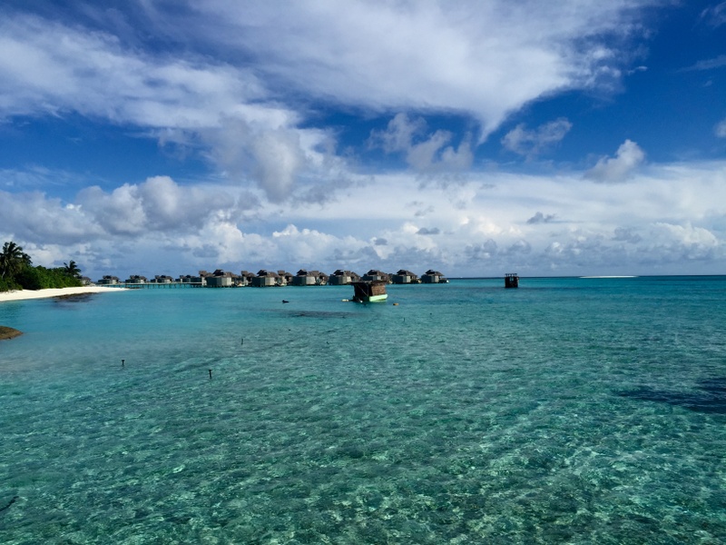 A quick word about the place...Flag as inappropriate ›Haddhunmathi Atoll or Laamu Atoll in the Maldives is natural atoll mostly rimmed by barrier reefs, the broadest of which are topped by islands. There are many islands along its eastern and southern boundaries. This atoll is quite regular excepting for the projection of the reef at its NE corner (Isdhū Muli). It closely resembles Kolhumadulhu, its neighbour further north. Owing to its typical atoll shape, it differs in no respect from atolls in the Pacific Ocean, save for its greater size. Its reefs are generally of little breadth, with no signs ofvilu(deep pools), except for its eastern fringes which are covered with islands that are quite large by Maldive standards. The lagoon is comparatively open, containing scattered shoal patches; the bottom is muddy and the average depth is from 30 to 34 fathoms (55 to 62 m). Laamu Atoll forms the southern limit of Central Maldives. Beyond the Huvadhu Kandu, the broadest channel between...SHOW MORE
 -
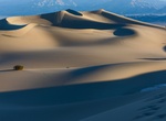
Hike or Sandboard Mesquite Flat Sand Dunes, Death Valley National Park...
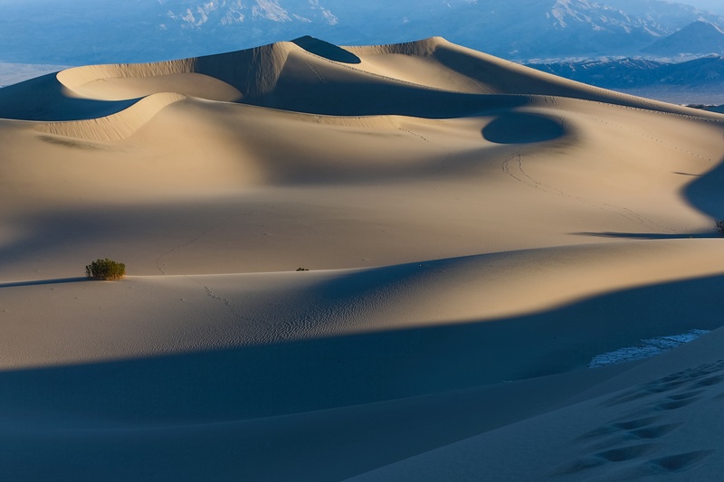 A quick word about the place...Flag as inappropriate ›The Mesquite Flat Sand Dunes are at the northern end of the valley floor of Death Valley National Park and are nearly surrounded by mountains on all sides. Due to their easy access from the road and the overall proximity of Death Valley to Hollywood, these dunes have been used to film sand dune scenes for several movies including films in the Star Wars series. Mesquite Flat Sand Dunes are the easiest to visit and the only location where sand boarding is allowed. The largest dune is called Star Dune and is relatively stable and stationary because it is at a point where the various winds that shape the dunes converge. The depth of the sand at its crest is 130–140 feet (40–43 m) but this is small compared to other dunes in the area that have sand depths of up to 600–700 feet (180–210 m) deep. The primary source of the dune sands is probably the Cottonwood Mountains which lie to the north and northwest. The...SHOW MORE
 -
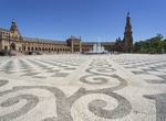
See Plaza de España, Seville, Spain
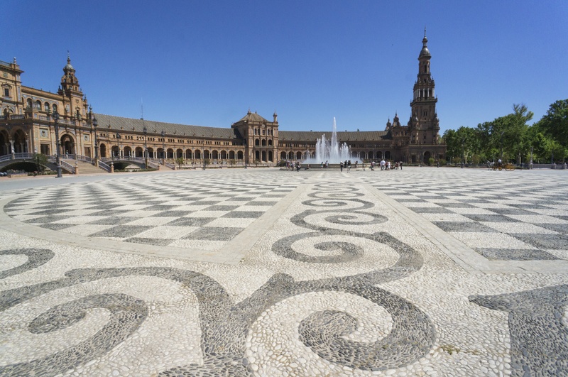 A quick word about the place...Flag as inappropriate ›The Plaza de España is a plaza located in the Parque de María Luisa (Maria Luisa Park), in Seville, Spain built in 1928 for the Ibero-American Exposition of 1929. It is a landmark example of the Renaissance Revival style in Spanish architecture. The Plaza de España mainly consists of Government buildings. The Seville Town Hall, with sensitive adaptive redesign, is located within it. The Plaza's tiled 'Alcoves of the Provinces' are backdrops for visitors portrait photographs, taken in their own home province's alcove. Towards the end of the park, the grandest mansions from the fair have been adapted as museums. The farthest contains the city's archaeology collections. The main exhibits are Roman mosaics and artefacts from nearby Italica. The Plaza de España has been used as a filming location, including scenes for the 1962 film Lawrence of Arabia. The building was used as a location in the Star Wars...SHOW MORE
 -
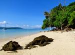
Explore Phang Nga Marine National Park, Thailand
 A quick word about the place...Flag as inappropriate ›Phang Nga Bay is a 400 km² bay in the Andaman Sea between the island of Phuket and the mainland of the Malay peninsula of southern Thailand. Ao Phang Nga park was created by Royal decree and announced in the Royal Gazette under proclamation number 98 section 64 of April 29, 1981, Limestone cliffs with caves, collapsed cave systems and archaeological sites are found about Phang Nga Bay. Some 10,000 years ago, when sea levels were lower, one could walk from Phuket and Krabi. Phang Nga Bay Marine National Park was declared a protected Ramsar Site (no. 1185) of international ecological significance on 14 August, 2002. Phang Nga is a shallow bay with 42 islands, comprising shallow marine waters and intertidal forested wetlands, with at least 28 species of mangrove; seagrass beds and coral reefs are also present. At least 88 bird species, including the globally threatened Malaysian Plover (Charadrius peronii) and Asiatic...SHOW MORE
Check out other Dreams from this list
-
1.
 Visit Reynisfjara Black...
-
2.
 Explore Mount Etna...
-
3.
 Visit Skellig Michael...
-
4.
 Drive to Dante's View...
-
5.
 Explore Wadi Rum, Jordan
-
6.
 Explore Humboldt Redwoods...
-
7.
 Explore Krafla Caldera...
-
8.
 Explore Tikal National...
-
9.
 Visit Ajim, Tunisia
-
10.
 Visit Medenine, Tunisia
-
11.
 Explore Whippendell...
-
12.
 Visit Canary Wharf...
-
13.
 Visit Finse, Norway
-
14.
 See Hardangerjøkulen...
-
15.
 Explore Grizzly Creek...
-
16.
 Visit Lars Family...
-
17.
 Visit Mos Espa (Annakin...
-
18.
 Visit Imperial Sand Dunes...
-
19.
 Drive Twenty-Mule Team...
-
20.
 Visit Villa del...
-
21.
 Stay at Hotel Sidi Driss...
-
22.
 Visit Laamu Atoll...
-
23.
 Hike or Sandboard...
-
24.
 See Plaza de España...
-
25.
 Explore Phang Nga Marine...