Give us feedback!


 See all

Our philosophy is simple. We want to encourage you to dream. BIG! Then we help you plan your trip, get the most out of it while you're traveling and help you share your experience with friends.
Join Now It's FREE
Dream Packages
Duration: 12 hours
Price: $263.50
Price: $263.50
Duration: 10 hours
Price: $224.21
Price: $224.21
Duration: 2 days
Price: $469.00
Price: $469.00
Duration: 12 hours
Price: $224.21
Price: $224.21
Related Categories
Dreams Still To Do
Checked-Off Dreams
Dreams Still To Do
Checked-Off Dreams
Advertisement
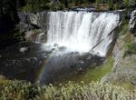
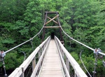
Explore Best Hikes in the US
-
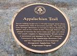
Hike Appalachian Trail (AT)
The Appalachian National Scenic Trail, generally known as the Appalachian Trail or simply the AT, is a marked hiking trail in the eastern United States extending between Springer Mountain in Georgia and Mount Katahdin in Maine. It is approximately 2,184 miles (3,515 km) long. The trail passes through the states of Georgia, North Carolina, Tennessee, Virginia, West Vir... -
Hike Belcher Ranger Station to Old Faithful, Yellowstone National Park, Wyoming
The 27 mile hike starts at the Belcher ranger station and takes aproxamitly 4 days to reach the Old Faithful geyser. This hike is recommended in August or September and is considered a "moderate" backpacking trip Old Faithful is a cone geyser located in Wyoming in Yellowstone National Park in the United States. Old Faithful was named in 1870 during the Washburn-Langfo... -
Hike Benton MacKaye Trail (BMT), Georgia, Tennessee & North Carolina
The Benton MacKaye Trail or BMT is a footpath nearly 300 miles (480 km) in length in the Appalachian Mountains in the southeastern United States and is blazed by a white diamond, 5" across by 7" tall. It's a great way to see the beauty of the southern Appalachians without the crowds of the Appalachian Trail. A speedy and disciplined hiker could do the trail in two wee... -
Hike Bizz Johnson National Recreation Trail, Lassen County, California
Following the old Fernley and Lassen Branch Line of the Southern Pacific railroad, the trail winds 25.4 miles from Susanville, California to Mason Station. For the first 16 miles, the trail follows the Susan River. As it winds through the rugged Susan River Canyon, the trail crosses the river 12 times on bridges and trestles and passes through two tunnels. The landsc... -
Hike Brevard Hiking Trail, Pisgah National Forest, North Carolina
Pisgah National Forest is a National Forest in the Appalachian Mountains of western North Carolina. It is administered by the United States Forest Service, part of the United States Department of Agriculture. The Pisgah National Forest is completely contained within the state of North Carolina. The forest is managed together with the other three North Carolina Nationa... -
Hike Canyon X, Arizona
Canyon X is a slot canyon just a few feet wide but more than 100 feet deep near Lake Powell in northern Arizona. This canyon has a lot of the same gorgeous features as nearby Antelope Canyon but without the crowds. It is on Navajo land that is privately run and is fenced off. Visits to Canyon X require a Navajo Reservation permit and are limited to four people at a t... -
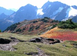
Hike Cascade Pass to Sahale Arm Trail, North Cascades National Park, Washington
Cascade Pass is a 5,392-foot (1,643 m) mountain pass over the northern Cascade Range, east of Marblemount, Washington, U.S. Although an important pass, providing the easiest connection from the Cascade River to the head of Lake Chelan, it is now inside North Cascades National Park, and crossed by only a hiking trail. From the west, one reaches it by hiking an easy 3.5... -
Hike Chilkoot Trail, USA & Canada
The Chilkoot Trail is a 33-miles (53 km) trail through the Coast Mountains that leads from Dyea, Alaska, in the United States, to Bennett, British Columbia, in Canada. The trail can take 3 to 5 days. Each year, over 15,000 people day hike, backpack, or trail run this corridor. It was a major access route from the coast to Yukon goldfields in the late 1890s. The trail... -
Hike Continental Divide Trail (CDT)
The Continental Divide National Scenic Trail (in short Continental Divide Trail) is a United States National Scenic Trail running 3,100 miles (5,000 km) between Mexico and Canada. It follows the Continental Divide along the Rocky Mountains and traverses five U.S. states — Montana, Idaho, Wyoming, Colorado, and New Mexico. In Montana it crosses Triple Divide Peak... -
Hike Coyote Gulch Slots Canyons, Utah
Coyote Gulch is a tributary of the Escalante River, located in Garfield and Kane Counties in southern Utah, in the western United States. Over 25 miles (40 km) long, it exhibits many of the geologic features found in the Canyons of the Escalante, including high vertical canyon walls, narrow slot canyons, domes, arches, and natural bridges. A popular recreational desti... -
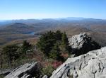
Hike Daniel Boone Scout Trail at Grandfather Mountain, North Carolina
Grandfather Mountain is a mountain and state park near Linville, North Carolina. At 5,946 feet (1,812 m), it is the highest peak on the eastern escarpment of the Blue Ridge Mountains, one of the major chains of the Appalachian Mountains. The Blue Ridge Parkway passes by the south side of the mountain. It is located at the meeting point of Avery, Caldwell (highest poin... -
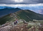
Hike Franconia Range Trail, New Hampshire
The Franconia Range is a mountain range located in the White Mountains of the U.S. state of New Hampshire. It is the second-highest range of peaks (after the Presidential Range) in the White Mountains. Franconia Ridge is a prominent ridge which forms the backbone of the range, stringing together all of its major summits. The Franconia Range hosts the third largest con... -
Hike or Rock Climb Garden of the Gods, Colorado Springs, Colorado
Garden of the Gods is a public park located in Colorado Springs, Colorado. The park was designated as a Great American Public Place of 2011 by the American Planning Association. The Great American Place are defined by many criteria, including architectural features, accessibility, functionality, and community involvement. The Garden of the Gods Park brings a lot of op... -
Hike or Mountain Bike George S. Mickelson Trail, South Dakota
The Mickelson Trail follows the abandoned Burlington Northern line that took trains from Edgemont, South Dakota up north to the Black Hills and the gold mines of the Deadwood area. At approximately 110 miles (176 km), cyclists will see a plethora of landscapes, ranging from distinctive granite rock formations to hay bale-dotted farmland. Among the highlights are stret... -
Hike Greenstone Ridge Trail, Isle Royale National Park, Michigan
The Greenstone Ridge Trail is the 40-mile (64.4 km)-long primary hiking trail that serves Isle Royale National Park. It extends from the a harbor on Isle Royale's western end, Windigo, to a harbor and lodge on its eastern end, Rock Harbor. As there are no paved roads in this wilderness area and park, the trail doubles as the primary means of land transportation on the...


Price: $289.36